Narrow Results By
Format
- Architectural Drawing 8
- Book 484
- Bylaws - Adopted 470
- Bylaws - Other 5
- Bylaws - Repealed 35
- Cartographic Material
- Council - 7
- Council - Committee Report 663
- Council - Information Report 15
- Council - Manager's Report 846
- Council - Mayor/Councillor/Staff Report 2179
- Council - Public Hearing Minutes 27
Creator
- Armstrong, Sophie 1
- Bancroft, Rose 1
- Burnett, David H. 1
- Burnett, Geoffrey K. 1
- Burnett & McGugan, Engineers and Surveyors 7
- Chow, Hipman "Jimmy" 1
- Draper, William Nelson 1
- Forsyth, Mary 1
- Garden, Hermon and Burwell 2
- Garden, Hermon & Burwell 1
- Gauvreau, Narcisse B. 1
- Government of British Columbia - Department of Mines and Resources 1
![All Saints Church, [ca.1910] thumbnail](/media/hpo/_Data/_BVM_Cartographic_Material/2003/2003_0083_0046_001.jpg?width=280)
All Saints Church
https://search.heritageburnaby.ca/link/museumdescription11924
- Repository
- Burnaby Village Museum
- Date
- [ca.1910]
- Collection/Fonds
- Ronald G. Scobbie collection
- Description Level
- Item
- Physical Description
- 1 plan : black ink and watercol. on paper ; 30.45 x 30.5 cm
- Scope and Content
- Item consists of building insurance plan of "All Saints Church / Lot "A" BK 29 DL 98 GP1 N.W.D.". Watling Street is idenfied to the north of the church building and Royal Oak Avenue to the west.
- Repository
- Burnaby Village Museum
- Collection/Fonds
- Ronald G. Scobbie collection
- Description Level
- Item
- Physical Description
- 1 plan : black ink and watercol. on paper ; 30.45 x 30.5 cm
- Material Details
- Scale 1 inch = 20 feet
- Scope and Content
- Item consists of building insurance plan of "All Saints Church / Lot "A" BK 29 DL 98 GP1 N.W.D.". Watling Street is idenfied to the north of the church building and Royal Oak Avenue to the west.
- Subjects
- Buildings - Religious - Churches
- Accession Code
- BV003.83.46
- Access Restriction
- No restrictions
- Reproduction Restriction
- No known restrictions
- Date
- [ca.1910]
- Media Type
- Cartographic Material
- Scan Resolution
- 600
- Scan Date
- 15-Jan-2021
- Scale
- 100
- Notes
- Transcribed title
- Note in pencil on verso reads: ""All Saints Church / Lot "A" BK 29 DL 98 / Scale 1 inch = 20 feet"
- Note in balck in on verso reads: "3704"
Images
![All Saints Church, [ca.1910] thumbnail](/media/hpo/_Data/_BVM_Cartographic_Material/2003/2003_0083_0046_001.jpg)
![Anglican Church, [ca.1910] thumbnail](/media/hpo/_Data/_BVM_Cartographic_Material/2003/2003_0083_0043_001.jpg?width=280)
Anglican Church
https://search.heritageburnaby.ca/link/museumdescription11921
- Repository
- Burnaby Village Museum
- Date
- [ca.1910]
- Collection/Fonds
- Ronald G. Scobbie collection
- Description Level
- Item
- Physical Description
- 1 plan : black ink and watercol. on paper ; 30.45 x 30.5 cm
- Scope and Content
- Item consists of building insurance plan of "Anglican Church / Lot 2 BK 37 DL69, GP.1, N.W.D. (15th Ave. (Dominion) is identified to the north of Lots 1, 2 and 3).
- Repository
- Burnaby Village Museum
- Collection/Fonds
- Ronald G. Scobbie collection
- Description Level
- Item
- Physical Description
- 1 plan : black ink and watercol. on paper ; 30.45 x 30.5 cm
- Material Details
- Scale 1 inch = 20 feet
- Scope and Content
- Item consists of building insurance plan of "Anglican Church / Lot 2 BK 37 DL69, GP.1, N.W.D. (15th Ave. (Dominion) is identified to the north of Lots 1, 2 and 3).
- Subjects
- Buildings - Religious - Churches
- Accession Code
- BV003.83.43
- Access Restriction
- No restrictions
- Reproduction Restriction
- No known restrictions
- Date
- [ca.1910]
- Media Type
- Cartographic Material
- Scan Resolution
- 600
- Scan Date
- 15-Jan-2021
- Scale
- 100
- Notes
- Transcribed title
- Note in pencil on verso reads: "Anglican Church / Lot 2 Bk 37 DL69 / 1"=20' "
- Note in balck in on verso reads: "3704"
Images
![Anglican Church, [ca.1910] thumbnail](/media/hpo/_Data/_BVM_Cartographic_Material/2003/2003_0083_0043_001.jpg)
Bancroft family subseries
https://search.heritageburnaby.ca/link/archivedescription63795
- Repository
- City of Burnaby Archives
- Date
- [1900]-1979
- Collection/Fonds
- Burnaby Historical Society fonds
- Description Level
- Subseries
- Physical Description
- Textual records and other materials
- Scope and Content
- Subseries consists of publications, correspondence and other miscellaneous papers relating to the Bancroft family's interests and work history. Topics include gardening, raising poultry, the Liberal government and the Royal Canadian Air Force. Also included in the subseries are photographs of the…
- Repository
- City of Burnaby Archives
- Date
- [1900]-1979
- Collection/Fonds
- Burnaby Historical Society fonds
- Subseries
- Bancroft family subseries
- Physical Description
- Textual records and other materials
- Description Level
- Subseries
- Accession Number
- BHS1986-44
- BHS2004-06
- Scope and Content
- Subseries consists of publications, correspondence and other miscellaneous papers relating to the Bancroft family's interests and work history. Topics include gardening, raising poultry, the Liberal government and the Royal Canadian Air Force. Also included in the subseries are photographs of the Bancroft family and friends and ephemera pertaining to agricultural farming and the air force.
- History
- Rose Croucher was born to Ann Eliza "Annie" (b. August 1861, d. 1962) and R. Coucher in January 1895. In 1907, the Croucher family moved to British Columbia. As a student, Rose studied geometrical drawing using Blair’s Canadian Drawing Series workbooks. On on February 21, 1914, Rose married James Oakes Bancroft in Vancouver, BC. Together they had three children: James A. (b. 1916 or 1917), Rosie (date unknown), and George E. (b. August 1927). The Bancroft family were poultry farmers throughout the early 1900s, transporting their farmed eggs from Burnaby to the Hudson’s Bay Company Vancouver using the British Columbia Electric Railway system. Rose Bancroft also served as Secretary-Treasurer of the Central Park Poultry Co-op Association in the 1920s until her husband's death in 1930 at the age of 42. In the late thirties and early forties, while James A. Bancroft was stationed in Calgary with the Royal Canadian Air Force, his younger siblings lived together with their mother and grandmother at 1963 21st Avenue in Burnaby. Rosie Bancroft studied French and English history in Social Studies in 1937; her brother George studied the seasons in General Science II in 1942. Rose died in 1965 at the age of 76.
- Media Type
- Textual Record
- Photograph
- Cartographic Material
- Creator
- Bancroft, Rose
- Notes
- MSS030, PC490, PC507, and MSS110
- Title based on creator and contents of subseries
Board of Railway Commissioners
https://search.heritageburnaby.ca/link/archivedescription396
- Repository
- City of Burnaby Archives
- Date
- 1909-1912
- Collection/Fonds
- City Council and Office of the City Clerk fonds
- Description Level
- File
- Physical Description
- Textual record, cartographic material, and architectural drawings
- Scope and Content
- File contains correspondence and reports related to the activities of the Board of Railway Commissioners such as the movement of stations, culvert work, and the maintenance of crossings. File also includes white linen plan and blueprint plans (4) of culverts at Cariboo Road and V.W. and Y.Rlwy Jun…
- Repository
- City of Burnaby Archives
- Date
- 1909-1912
- Collection/Fonds
- City Council and Office of the City Clerk fonds
- Physical Description
- Textual record, cartographic material, and architectural drawings
- Description Level
- File
- Record No.
- 2096
- Accession Number
- 2001-02
- Scope and Content
- File contains correspondence and reports related to the activities of the Board of Railway Commissioners such as the movement of stations, culvert work, and the maintenance of crossings. File also includes white linen plan and blueprint plans (4) of culverts at Cariboo Road and V.W. and Y.Rlwy Junction, 1911.
- Notes
- Plans/maps are located in file and have not been moved to map case.
Boundary Plan - Location for Burnaby Council of the West Boundary of Lots 161 and 175 Group One
https://search.heritageburnaby.ca/link/archivedescription8042
- Repository
- City of Burnaby Archives
- Date
- [1909]
- Collection/Fonds
- City Council and Office of the City Clerk fonds
- Description Level
- Item
- Physical Description
- Cartographic material
- Scope and Content
- Item consists of one plan on waxed linen with colour ink noting the western boundary of District Lots 161 and 175.
- Repository
- City of Burnaby Archives
- Date
- [1909]
- Collection/Fonds
- City Council and Office of the City Clerk fonds
- Physical Description
- Cartographic material
- Description Level
- Item
- Record No.
- 10997
- Accession Number
- 2001-02
- Scope and Content
- Item consists of one plan on waxed linen with colour ink noting the western boundary of District Lots 161 and 175.
- Media Type
- Cartographic Material
- Notes
- Located in map case.
![Broadview Presbyterian Church, [ca.1910] thumbnail](/media/hpo/_Data/_BVM_Cartographic_Material/2003/2003_0083_0049_001.jpg?width=280)
Broadview Presbyterian Church
https://search.heritageburnaby.ca/link/museumdescription11927
- Repository
- Burnaby Village Museum
- Date
- [ca.1910]
- Collection/Fonds
- Ronald G. Scobbie collection
- Description Level
- Item
- Physical Description
- 1 plan : black ink and watercol. on paper ; 30.45 x 30.5 cm
- Scope and Content
- Item consists of building insurance plan of "Broadview Presbyterian Church / Lot 6, BK 31, DL 69 / GP1 N.W.D." . Fourteenth Avenue (Manor) is identified to the north and Douglas Ave. to the east.
- Repository
- Burnaby Village Museum
- Collection/Fonds
- Ronald G. Scobbie collection
- Description Level
- Item
- Physical Description
- 1 plan : black ink and watercol. on paper ; 30.45 x 30.5 cm
- Material Details
- Scale 1 inch = 20 feet
- Scope and Content
- Item consists of building insurance plan of "Broadview Presbyterian Church / Lot 6, BK 31, DL 69 / GP1 N.W.D." . Fourteenth Avenue (Manor) is identified to the north and Douglas Ave. to the east.
- Subjects
- Buildings - Religious - Churches
- Accession Code
- BV003.83.49
- Access Restriction
- No restrictions
- Reproduction Restriction
- No known restrictions
- Date
- [ca.1910]
- Media Type
- Cartographic Material
- Scan Resolution
- 600
- Scan Date
- 15-Jan-2021
- Scale
- 100
- Notes
- Transcribed title
- Note in pencil on verso reads: "Broadview Presbyterian Church / Lot 6, BK 31, DL 69 / 1" = 20' "
- Note in balck in on verso reads: "3704"
Images
![Broadview Presbyterian Church, [ca.1910] thumbnail](/media/hpo/_Data/_BVM_Cartographic_Material/2003/2003_0083_0049_001.jpg)
Cameron Road
https://search.heritageburnaby.ca/link/archivedescription324
- Repository
- City of Burnaby Archives
- Date
- [1904]
- Collection/Fonds
- City Council and Office of the City Clerk fonds
- Description Level
- File
- Physical Description
- Textual record and cartographic material
- Scope and Content
- File contains Cameron Road Plan.
- Repository
- City of Burnaby Archives
- Date
- [1904]
- Collection/Fonds
- City Council and Office of the City Clerk fonds
- Physical Description
- Textual record and cartographic material
- Description Level
- File
- Record No.
- 2017
- Accession Number
- 2001-02
- Scope and Content
- File contains Cameron Road Plan.
- Media Type
- Textual Record
- Cartographic Material
- Notes
- Plans/maps are located in file and have not been moved to map case.
Cancellation of plan - Block 2, DL 77
https://search.heritageburnaby.ca/link/archivedescription1142
- Repository
- City of Burnaby Archives
- Date
- [Between 1890 - 1918]
- Collection/Fonds
- City Council and Office of the City Clerk fonds
- Description Level
- File
- Physical Description
- Textual record and cartographic material
- Scope and Content
- Files consists of cancellation of plan Block 2, DL 77 and two accompanied blueprints 434 (April 8, 1890) and 238 (December 30, 1887)
- Repository
- City of Burnaby Archives
- Date
- [Between 1890 - 1918]
- Collection/Fonds
- City Council and Office of the City Clerk fonds
- Physical Description
- Textual record and cartographic material
- Description Level
- File
- Record No.
- 2933
- Accession Number
- 2001-02
- Scope and Content
- Files consists of cancellation of plan Block 2, DL 77 and two accompanied blueprints 434 (April 8, 1890) and 238 (December 30, 1887)
- Media Type
- Textual Record
- Cartographic Material
- Notes
- Plan of Lot 77, group 1 NWD : M9-B-1-4. Plan of subdivision of blocks 2-6, lot 77, group 1 NWD : M9-B-1-5
Crossing - B.C. Electric Railway Co.
https://search.heritageburnaby.ca/link/archivedescription657
- Repository
- City of Burnaby Archives
- Date
- 1909-1913
- Collection/Fonds
- City Council and Office of the City Clerk fonds
- Description Level
- File
- Physical Description
- Textual record and cartographic material
- Scope and Content
- File contains correspondence and reports pertaining to crossings on B.C. Electric Railway lines at Cariboo, Hastings, Boundary, Gilley, Jubilee, McKay, and Patterson.
- Repository
- City of Burnaby Archives
- Date
- 1909-1913
- Collection/Fonds
- City Council and Office of the City Clerk fonds
- Physical Description
- Textual record and cartographic material
- Description Level
- File
- Record No.
- 2382
- Accession Number
- 2001-02
- Scope and Content
- File contains correspondence and reports pertaining to crossings on B.C. Electric Railway lines at Cariboo, Hastings, Boundary, Gilley, Jubilee, McKay, and Patterson.
- Media Type
- Textual Record
- Cartographic Material
- Notes
- Vancouver and Lulu Island Railway Westminster and Eburne Byrne Road Crossing at Station 355 : M9-A-6-5; Trapp Road Crossing at Station 425 : M9-A-6-6
Ditches and water courses
https://search.heritageburnaby.ca/link/archivedescription662
- Repository
- City of Burnaby Archives
- Date
- 1908
- Collection/Fonds
- City Council and Office of the City Clerk fonds
- Description Level
- File
- Physical Description
- Textual record and cartographic material
- Scope and Content
- File contains reports, correspondence, declarations and appeals related to the construction of ditches and water courses as well as the application to construct ditches made by Ida I. Dow, William Buckoll, and O. Goodacre. File also includes white linen plan of "Proposed Ditch in lot 153, G1, NWD…
- Repository
- City of Burnaby Archives
- Date
- 1908
- Collection/Fonds
- City Council and Office of the City Clerk fonds
- Physical Description
- Textual record and cartographic material
- Description Level
- File
- Record No.
- 2387
- Accession Number
- 2001-02
- Scope and Content
- File contains reports, correspondence, declarations and appeals related to the construction of ditches and water courses as well as the application to construct ditches made by Ida I. Dow, William Buckoll, and O. Goodacre. File also includes white linen plan of "Proposed Ditch in lot 153, G1, NWD" located at M9-B-3-20.
- Media Type
- Textual Record
- Cartographic Material
- Notes
- A map of Proposed Ditch in Lot 153 : M9-B-3-20
Ditches and water courses (Sprott)
https://search.heritageburnaby.ca/link/archivedescription668
- Repository
- City of Burnaby Archives
- Date
- 1908
- Collection/Fonds
- City Council and Office of the City Clerk fonds
- Description Level
- File
- Physical Description
- Textual records, cartographic material and architectural material
- Scope and Content
- File contains correspondence, certificates signed by the District Engineer attesting to the fact that ditches were constructed according to the Ditches and Waterworks Act, as well as notices to residents that ditches were to be built along their property. File also includes 2 blueprint plans and 1…
- Repository
- City of Burnaby Archives
- Date
- 1908
- Collection/Fonds
- City Council and Office of the City Clerk fonds
- Physical Description
- Textual records, cartographic material and architectural material
- Description Level
- File
- Record No.
- 2393
- Accession Number
- 2001-02
- Scope and Content
- File contains correspondence, certificates signed by the District Engineer attesting to the fact that ditches were constructed according to the Ditches and Waterworks Act, as well as notices to residents that ditches were to be built along their property. File also includes 2 blueprint plans and 1 linen map of DL 79.
- Notes
- Plans/maps are located in file and have not been moved to map case.
Ditches - Woolard v. Burnaby
https://search.heritageburnaby.ca/link/archivedescription670
- Repository
- City of Burnaby Archives
- Date
- 1904-1907
- Collection/Fonds
- City Council and Office of the City Clerk fonds
- Description Level
- File
- Physical Description
- Textual record and cartographic material
- Scope and Content
- File contains correspondence and court transcripts from the trial John Woolard v. Municipality of Burnaby which arose from charges brought against Burnaby for interfering with a ditch built by Woolard. File includes a blueprint plan of "Profile on Water Surface in Holland Road Ditch and Woollard's…
- Repository
- City of Burnaby Archives
- Date
- 1904-1907
- Collection/Fonds
- City Council and Office of the City Clerk fonds
- Physical Description
- Textual record and cartographic material
- Description Level
- File
- Record No.
- 2395
- Accession Number
- 2001-02
- Scope and Content
- File contains correspondence and court transcripts from the trial John Woolard v. Municipality of Burnaby which arose from charges brought against Burnaby for interfering with a ditch built by Woolard. File includes a blueprint plan of "Profile on Water Surface in Holland Road Ditch and Woollard's Ditch " (1904) and a linen plan of Woollard's and Hooland Road ditches (lot 155a, group 1).
- Media Type
- Textual Record
- Cartographic Material
- Notes
- Plans/maps are located in file and have not been moved to map case.
![Dundonald United Church, [ca.1910] thumbnail](/media/hpo/_Data/_BVM_Cartographic_Material/2003/2003_0083_0052_001.jpg?width=280)
Dundonald United Church
https://search.heritageburnaby.ca/link/museumdescription11930
- Repository
- Burnaby Village Museum
- Date
- [ca.1910]
- Collection/Fonds
- Ronald G. Scobbie collection
- Description Level
- Item
- Physical Description
- 1 plan : black ink and watercol. on paper ; 30.45 x 30.5 cm
- Scope and Content
- Item consists of a building insurance plan of "Dundonald United Church / Lots 9, 10 BK 28 DL 159 GP 1 / N.W.D.". Clinton Street is identified to the north of Lots nine and ten.
- Repository
- Burnaby Village Museum
- Collection/Fonds
- Ronald G. Scobbie collection
- Description Level
- Item
- Physical Description
- 1 plan : black ink and watercol. on paper ; 30.45 x 30.5 cm
- Material Details
- Scale 1 inch = 20 feet
- Scope and Content
- Item consists of a building insurance plan of "Dundonald United Church / Lots 9, 10 BK 28 DL 159 GP 1 / N.W.D.". Clinton Street is identified to the north of Lots nine and ten.
- Subjects
- Buildings - Religious - Churches
- Names
- Dundonald United Church
- Accession Code
- BV003.83.52
- Access Restriction
- No restrictions
- Reproduction Restriction
- No known restrictions
- Date
- [ca.1910]
- Media Type
- Cartographic Material
- Scan Resolution
- 600
- Scan Date
- 15-Jan-2021
- Scale
- 100
- Notes
- Transcribed title
- Note in pencil on verso reads: "_ _Church / Lots 9 & 10 BK 28 DL 159 / 1" = 20' "
- Note in black ink on verso reads: "3704"
Images
![Dundonald United Church, [ca.1910] thumbnail](/media/hpo/_Data/_BVM_Cartographic_Material/2003/2003_0083_0052_001.jpg)
Ephemera subseries
https://search.heritageburnaby.ca/link/archivedescription97408
- Repository
- City of Burnaby Archives
- Date
- 1893 (date of original)-2004
- Collection/Fonds
- Burnaby Historical Society fonds
- Description Level
- Subseries
- Physical Description
- Textual records and cartographic records
- Scope and Content
- Subseries consists of newspapers, printed material, publications, artworks, maps and other ephemera items collected or purchased by the Burnaby Historical Society for inclusion in their Community Archives.
- Repository
- City of Burnaby Archives
- Date
- 1893 (date of original)-2004
- Collection/Fonds
- Burnaby Historical Society fonds
- Subseries
- Ephemera subseries
- Physical Description
- Textual records and cartographic records
- Description Level
- Subseries
- Accession Number
- BHS1985-22
- BHS1986-01
- BHS1986-16
- BHS1986-43
- BHS1988-02
- BHS1988-12
- BHS1988-14
- BHS1989-09
- BHS1989-11
- BHS1989-14
- BHS1989-16
- BHS1991-26
- BHS1991-35
- BHS1991-40
- BHS1992-01
- BHS1994-09
- BHS1995-13
- BHS1995-17
- BHS1996-10
- BHS1997-06
- BHS1997-10
- BHS1999-04
- BHS1999-08
- BHS2000-12
- BHS2004-09
- BHS2004-11
- BHS2005-04
- BHS2005-05
- BHS2007-03
- BHS2007-04
- Scope and Content
- Subseries consists of newspapers, printed material, publications, artworks, maps and other ephemera items collected or purchased by the Burnaby Historical Society for inclusion in their Community Archives.
- Media Type
- Textual Record
- Cartographic Material
- Notes
- Title based on content of subseries
- PC212, PC219, PC472, PC598, MSS005, MSS010, MSS034, MSS038, MSS046, MSS076, MSS081, MSS090, MSS111, MSS114, MSS119, MSS195
Gunn Road diversion (Banfield, J.J.)
https://search.heritageburnaby.ca/link/archivedescription319
- Repository
- City of Burnaby Archives
- Date
- 1905-1911
- Collection/Fonds
- City Council and Office of the City Clerk fonds
- Description Level
- File
- Physical Description
- Textual record and cartographic material
- Scope and Content
- File contains records, including blueprint, related to the proposed diversion of Gunn Road.
- Repository
- City of Burnaby Archives
- Date
- 1905-1911
- Collection/Fonds
- City Council and Office of the City Clerk fonds
- Physical Description
- Textual record and cartographic material
- Description Level
- File
- Record No.
- 2010
- Accession Number
- 2001-02
- Scope and Content
- File contains records, including blueprint, related to the proposed diversion of Gunn Road.
- Media Type
- Textual Record
- Cartographic Material
- Notes
- White linen plan : Diversion of Gunn Road Lots 10 and 4 Group One" : M9-A-3-17.
Hastings Road
https://search.heritageburnaby.ca/link/archivedescription458
- Repository
- City of Burnaby Archives
- Date
- 1908-1909
- Collection/Fonds
- City Council and Office of the City Clerk fonds
- Description Level
- File
- Physical Description
- Textual record and cartographic material
- Scope and Content
- File consists of correspondence and reports arising from a survey of Hastings Road and two maps associated with the correspondence. One map is of Hastings Road through Westminster District and the the other is a tracing of Douglas Road from original notes of the Royal Engineers.
- Repository
- City of Burnaby Archives
- Date
- 1908-1909
- Collection/Fonds
- City Council and Office of the City Clerk fonds
- Physical Description
- Textual record and cartographic material
- Description Level
- File
- Record No.
- 2163
- Accession Number
- 2001-02
- Scope and Content
- File consists of correspondence and reports arising from a survey of Hastings Road and two maps associated with the correspondence. One map is of Hastings Road through Westminster District and the the other is a tracing of Douglas Road from original notes of the Royal Engineers.
- Media Type
- Textual Record
- Cartographic Material
- Notes
- A map of Hastings Road through N. West (1909) : M9-B-1-1; "Tracing of original notes from Royal Engineers of Douglas Road" : M9-B-1-2
Hastings Road diversion
https://search.heritageburnaby.ca/link/archivedescription322
- Repository
- City of Burnaby Archives
- Date
- [1906]
- Collection/Fonds
- City Council and Office of the City Clerk fonds
- Description Level
- File
- Physical Description
- Textual record and cartographic material
- Scope and Content
- File contains record of surveys done for Hastings Road diversion. White linen plans in map case.
- Repository
- City of Burnaby Archives
- Date
- [1906]
- Collection/Fonds
- City Council and Office of the City Clerk fonds
- Physical Description
- Textual record and cartographic material
- Description Level
- File
- Record No.
- 2015
- Accession Number
- 2001-02
- Scope and Content
- File contains record of surveys done for Hastings Road diversion. White linen plans in map case.
- Media Type
- Textual Record
- Cartographic Material
- Notes
- Survey of Hastings Road from Hastings Townsite to Still Creek : M9-A-3-2; M9-A-3-7
Hipman "Jimmy" Chow and Donna Polos fonds
https://search.heritageburnaby.ca/link/museumdescription19150
- Repository
- Burnaby Village Museum
- Date
- 1950-2022
- Collection/Fonds
- Hipman "Jimmy" Chow and Donna Polos fonds
- Description Level
- Fonds
- Physical Description
- 3 sound recordings (wav) + 1 sound recording (mp3) + 65 photographs + 26 photographs (jpg) + 1 portfolio (15 col. photographs + 12 col. laser prints) + 1 col. laser print + 6 business cards + 1 identification card + 1 booklet
- Scope and Content
- Fonds consists of an oral history interview with Jimmy Chow and his wife, Donna Polos; photographs of Jimmy Chow and his family soon after they immigrated to Canada in the 1950s as well as a sampling of photographs and records documenting Jimmy Chow's career in the film industry. Fonds is arranged…
- Repository
- Burnaby Village Museum
- Collection/Fonds
- Hipman "Jimmy" Chow and Donna Polos fonds
- Description Level
- Fonds
- Physical Description
- 3 sound recordings (wav) + 1 sound recording (mp3) + 65 photographs + 26 photographs (jpg) + 1 portfolio (15 col. photographs + 12 col. laser prints) + 1 col. laser print + 6 business cards + 1 identification card + 1 booklet
- Scope and Content
- Fonds consists of an oral history interview with Jimmy Chow and his wife, Donna Polos; photographs of Jimmy Chow and his family soon after they immigrated to Canada in the 1950s as well as a sampling of photographs and records documenting Jimmy Chow's career in the film industry. Fonds is arranged into series: 1) Jimmy Chow and Donna Polos interviews series 2) Jimmy Chow family photographs series 3) Property master photographs series 4) Property master records series
- History
- Hipman "Jimmy" Chow was born in Lin Pong Lee, Hoiping, China in 1948. In 1950, Jimmy Chow and his mother, Gim Gee Chow (1913-1991) fled China to escape the Communist Revolution and to be reunited with his father, Robin Chung Dip Chow (1906-1990) who’d immigrated to Canada many years earlier. Jimmy’s elder sister Shao-Lin Chow stayed behind in China. Jimmy’s father, Robin Chung Dip Chow immigrated to Canada in 1921 at 14 years of age and was forced to pay the Chinese head tax of $500. In 1950, Jimmy and his mother first fled to Hong Kong before immigrating to Canada and arriving in Vancouver. Jimmy Chow’s birth name is Hipman Chow but when he arrived in Canada, his father indicated that he needed an English name and he was given the name “Jimmy” but retained his birth name “Hipman Chow”. Over the years, Jimmy has also used the name “James H. Chow” and is often credited by this name in the film industry. For the first four years after immigrating, Jimmy and his parents lived in Manitoba, Saskatchewan and Quebec where his father had work in hotels and restaurants. While living in Asquith, Saskatchewan Jimmy attended school and began to learn English. In 1954, Jimmy and his parents returned to Vancouver, first living in the area of Strathcona before settling in the neighbourhood of Mount Pleasant where they purchased a house located on 15th Avenue east of Main Street. While living in Mount Pleasant, Jimmy attended both elementary and high school. While attending high school, Jimmy began working at the local grocery store where he worked for many years living at home and saving his money. In 1970 while attending Vancouver City College, Jimmy met his future wife Donna Polos. Two years later, they moved in together, married in 1981 and started a family. Jimmy and Donna first lived in North Burnaby before purchasing a house on Victory Street in Burnaby where they raised their three children. Growing up in a traditional Chinese Canadian family, Jimmy was always one who went against the grain. Although his father wanted him to get a business degree, Jimmy had aspirations for a different career path. Through the referral of a friend, he entered the film industry in 1973 working for CBC Vancouver. While working at the CBC, Jimmy gained valuable experience working on the set of the television series The Beachcombers, which launched his career in the film industry. Over a 45 year career, Jimmy worked on over 50 blockbuster movies, historical period films, science fiction films and fantasy films, where he honed in on his expertise as a set decorator, art director and property master. He built an international reputation through working with production companies, prop makers and antique sellers across the globe. As a property master in the film industry, Jimmy Chow has been responsible for designing, managing, and sourcing props for films such as: The BFG, Warcraft: The Beginning, X-Men 2, Fantastic Four, Watchman, Tron: Legacy, Little Women, Seven Years in Tibet, Shanghai Noon, The Shipping News, Fantastic Four: Rise of the Silver Surfer, The Changeling, Man of Steel (Superman), Snow Falling on Cedars, Legends of the Fall, And the Sea Will Tell, Once a Thief and many more. With Jimmy's many years of professional experience in the film industry, he has been a union member of IATSE (International Alliance of Theatrical Stage Employees, Moving Picture Technicians...) from July 1979, a member of the Academy of Motion Picture Arts and Science from 2018 and has worked as a guest lecturer in film production at Capilano University and Langara University. He was also a key contributor to the Burnaby Village Museum’s 2014 temporary exhibition Burnaby Makes Movies. Donna Polos was born in Vancouver in 1949 to parents Mayme "May" Helen Tillikana Polos (1931-1977) and Donald James Polos (1926-2017). Donna’s maternal grandparents, Elvi Tienhara and Toiva Tillikana immigrated to Canada from Helsinki, Finland. Donna’s paternal grandmother, Pauline Chimiki Polos emigrated from Ukraine to Argentina and then to Winnipeg. Donna’s paternal grandfather, James "Jimmy" Kostopolus emigrated as an orphan from Sparta Greece at the age of 12 years. In 1908, he first immigrated to the United States where he was denied entry so immigrated to Canada, entering through Halifax at Pier 17. When immigrating, James changed his last name to "Polos". Jimmy Polos arrived in Halifax with only five dollars in his pocket. He lived in Halifax for many years before making his way to Vancouver where he established three restaurants and raised his family. James was the proprietor of three restaurants in Burnaby including; the Home Apple Pie Café (1941-1944) located on East Hastings near Princess Avenue; Jimmy’s Café (1945-1955) located on East Hastings near Hawks Avenue and another restaurant located near 10th Avenue and Alma Street. Donna grew up with her family in Vancouver, first living in the downtown eastside before moving to a home near Joyce Station. Donna attended elementary school and high school while growing up in the neighbourhood of Joyce Station. Donna moved out of her family home at 21 years of age and lived with roommates before moving in with Jimmy Chow in 1972. Donna attended Vancouver City College and the University of British Columbia where she obtained her teaching degree in 1974. Donna first taught at Gilmore Elementary School before being hired to teach at Clinton Elementary School where she taught for nine years. While raising their three children, Donna worked part time teaching in schools in Burnaby. In 1991, after a near death experience, Donna became interested in fine art and took drawing and watercolour painting classes. This experience led her to experimenting with different painting techniques on paper and fabric. In 2008, Donna retired from teaching but continued her art career often working as an Artist in Residence at various schools and exhibiting her work. While living in Burnaby Donna has been politically active with a particular passion for heritage, housing and preserving the natural environment. Donna was instrumental in advocating and petitioning for the establishment of a tree bylaw in Burnaby which was eventually adopted by the City.
- Creator
- Chow, Hipman "Jimmy"
- Polos, Donna
- Accession Code
- BV022.21
- BV023.11
- Date
- 1950-2022
- Media Type
- Sound Recording
- Photograph
- Textual Record
- Graphic Material
- Notes
- Title based on contents of fonds
- Hipman "Jimmy" Chow's name in Cantonese is Chow Hipman and in Mandarin is Zhou Xiamin.
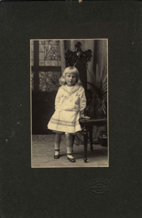
Kitty Hill
https://search.heritageburnaby.ca/link/archivedescription66567
- Repository
- City of Burnaby Archives
- Date
- 1904
- Collection/Fonds
- Peers Family and Hill Family fonds
- Description Level
- Item
- Physical Description
- 1 photograph : b&w + 1 watercolour painting
- Scope and Content
- Photograph is a portrait of Kitty Hill, posing next to a high-back chair. Accompanying the photograph is a watercolour painting that was based on this photograph, done on a linen backing.
- Repository
- City of Burnaby Archives
- Date
- 1904
- Collection/Fonds
- Peers Family and Hill Family fonds
- Physical Description
- 1 photograph : b&w + 1 watercolour painting
- Description Level
- Item
- Record No.
- 477-1181
- Access Restriction
- No restrictions
- Reproduction Restriction
- No known restrictions
- Accession Number
- 2007-12
- Scope and Content
- Photograph is a portrait of Kitty Hill, posing next to a high-back chair. Accompanying the photograph is a watercolour painting that was based on this photograph, done on a linen backing.
- Media Type
- Photograph
- Graphic Material
- Notes
- Title based on contents of photograph
Images

Love and Leonard land records series
https://search.heritageburnaby.ca/link/museumdescription18838
- Repository
- Burnaby Village Museum
- Date
- 1893-1962
- Collection/Fonds
- Love family fonds
- Description Level
- Series
- Physical Description
- 5 plans + 8 cm of textual records
- Scope and Content
- Series consists of land deeds, land sale agreements, documents regarding payment and survey and subdivision plans. Records refer to the Love family property in District Lot 25, the Leonard family property in District Lot 352 and other lots in Burnaby.
- Repository
- Burnaby Village Museum
- Collection/Fonds
- Love family fonds
- Description Level
- Series
- Physical Description
- 5 plans + 8 cm of textual records
- Scope and Content
- Series consists of land deeds, land sale agreements, documents regarding payment and survey and subdivision plans. Records refer to the Love family property in District Lot 25, the Leonard family property in District Lot 352 and other lots in Burnaby.
- Accession Code
- BV992.26
- BV012.31
- Date
- 1893-1962
- Media Type
- Textual Record
- Cartographic Material
- Notes
- Title based on contents of series