Narrow Results By
Decade
- 2020s 220
- 2010s 147
- 2000s 1757
- 1990s 2744
- 1980s 1104
- 1970s
- 1960s 927
- 1950s 1323
- 1940s 1465
- 1930s 1448
- 1920s 1732
- 1910s 1456
- 1900s 702
- 1890s 180
- 1880s 110
- 1870s 18
- 1860s 25
- 1850s 10
- 1840s 5
- 1830s 2
- 1820s 2
- 1810s 3
- 1800s 3
- 1790s 2
- 1780s
- 1770s 2
- 1760s 2
- 1750s 2
- 1740s 2
- 1730s 2
- 1720s 2
- 1710s 2
- 1700s 2
- 1690s 2
- 1680s 2
- 1670s 1
- 1660s 1
- 1650s 1
- 1640s
- 1630s
- 1620s 1
- 1610s 1
- 1600s 1
- 1590s 1
- 1580s 1
- 1570s 1
- 1560s 1
- 1550s 1
- 1540s 1
- 1530s 1
- 1520s 2
- 1510s 1
- 1500s 1
- 1490s 1
- 1480s 1
Subject
- Accidents 1
- Accidents - Train Accidents 6
- Adminstrative Groups - Committees 4
- Advertising Medium 1
- Advertising Medium - Flyer 3
- Advertising Medium - Poster 13
- Advertising Medium - Signs and Signboards 70
- Aerial Photographs 45
- Agriculture - Farms 58
- Agriculture - Fruit and Berries 1
- Agriculture - Poultry 1
- Animals 2

Government Road Neighbourhood
https://search.heritageburnaby.ca/link/landmark822
- Repository
- Burnaby Heritage Planning
- Associated Dates
- 1955-2008
- Heritage Value
- After the building boom of the 1950s, the Government Road Neighbourhood became characterised as a stable, single-family residential area. In addition to the residential component, the neighbourhood also has a significant industrial sector, along the north side of Burnaby Lake, and a commercial zone to the north along the Lougheed Highway.
- Historic Neighbourhood
- Lozells (Historic Neighbourhood)
- Planning Study Area
- Government Road Area
Images


Lake City Neighbourhood
https://search.heritageburnaby.ca/link/landmark793
- Repository
- Burnaby Heritage Planning
- Associated Dates
- 1955-2008
- Heritage Value
- When Simon Fraser University opened in 1965, approximately sixteen industrial properties had been developed in the Lake City Industrial Park. In addition, significant tracts of land in the western portion had been pre-cleared and graded in anticipation of additional development, while most of the eastern half remained forested. Some of the early companies to locate in the area were Nabob Foods, Volkswagen Canada, British Columbia Television Broadcasting, Simpson Sears, and H.Y. Louie Company Limited. Both Imperial Oil and Shell Oil established petroleum storage and distribution facilities in the area. Initially a heavy industrial area, by 1979, single family neighbourhoods south of Lougheed Highway and west of Eagle Creek had been largely developed. By the mid1980's, the Burnaby 200 multi-family development along Forest Grove Drive had also been completed.
- Planning Study Area
- Lake City Area
Images


Lakeview-Mayfield Neighbourhood
https://search.heritageburnaby.ca/link/landmark830
- Repository
- Burnaby Heritage Planning
- Associated Dates
- 1955-2008
- Heritage Value
- Like many other areas of the City, the Lakeview-Mayfield Neighbourhood was subdivided during the 1950s post-war building boom. Pockets of newer homes were built in the 1970s, and the neighbourhood retained its character as a primarily residential area. The neighbourhood is bordered to the east by Robert Burnaby Park.
- Planning Study Area
- Lakeview-Mayfield Area
Images


Lyndhurst Neighbourhood
https://search.heritageburnaby.ca/link/landmark823
- Repository
- Burnaby Heritage Planning
- Associated Dates
- 1955-2008
- Heritage Value
- The Lyndhurst Neighbourhood falls within the Lougheed Town Centre area - one of four Town Centres in Burnaby. The Lyndhurst Neighbourhood accounts for a significant portion of the residential component of the Town Centre. To the east of Stoney Creek Park, lies the Sullivan Heights single family subdivision which was built in the 1950s. To the west of the park, is a higher-density residential area consisting of multi-family buildings that were developed after 1974.
- Historic Neighbourhood
- Burquitlam (Historic Neighbourhood)
- Planning Study Area
- Lyndhurst Area
Images


Oakalla Neighbourhood
https://search.heritageburnaby.ca/link/landmark804
- Repository
- Burnaby Heritage Planning
- Associated Dates
- 1955-2008
- Heritage Value
- The phasing out and demolition of the Oakalla Prison farm allowed for the planned development of the Oakalla Neighbourhood in the 1980s. By 1991, the City of Burnaby had adopted the Oakalla Development Plan which called for the transfer of land to the Deer Lake Park reserve as well as the creation of a new residential area consisting of multi-family housing types.
- Historic Neighbourhood
- Central Park (Historic Neighbourhood)
- Planning Study Area
- Oakalla Area
Images


Riverside School
https://search.heritageburnaby.ca/link/landmark711
- Repository
- Burnaby Heritage Planning
- Geographic Access
- Marine Drive
- Associated Dates
- 1953-1983
- Heritage Value
- The south-east corner of Burnaby featured homes that were scattered in a rural setting. Previously, Riverway East and then Clinton Elementary School had served this neighbourhood, but a more central location was preferable to the School Board to limit bussing of students, so Riverside School was opened in 1953. There were 84 students registered in its first year, but by the late 1970s, enrolments across the City had declined and a number of schools, including Riverside, were closed.
- Historic Neighbourhood
- Fraser Arm (Historic Neighbourhood)
- Planning Study Area
- Big Bend Area
Images


Shell Oil Company
https://search.heritageburnaby.ca/link/landmark675
- Repository
- Burnaby Heritage Planning
- Geographic Access
- Kensington Avenue
- Associated Dates
- ca. 1930-1993
- Heritage Value
- After considering several sites in the Greater Vancouver area, the Shell Oil Company chose 70 acres in North Burnaby with frontage of one third of a mile on Burrard Inlet. Shell proposed to build a four-million dollar plant that would employ up to 2000 - providing some relief in the middle of Burnaby's economic crisis of the Depression years. The site became known as the Shellburn Refinery and was in operation until 1993.
- Historic Neighbourhood
- Lochdale (Historic Neighbourhood)
- Planning Study Area
- Westridge Area
Images


Sperling-Broadway Neighbourhood
https://search.heritageburnaby.ca/link/landmark789
- Repository
- Burnaby Heritage Planning
- Associated Dates
- 1955-2008
- Heritage Value
- By the 1970s, the Sperling-Broadway Neighbourhood was characterised as one of the Municipality's fastest growing residential areas. In 1980, it was estimated that slightly less than half of the homes were single-family residences, while the remaining development was taking the form of townhouse and high-rise apartments. The emphasis shifted back to single family housing during the construction of planned subdivisions such as the Camrose subdivision in the 1980s and the area remains primarily residential in nature. The neighbourhood is well-served by park facilities and is also home to the Burnaby Mountain Golf Course.
- Historic Neighbourhood
- Lochdale (Historic Neighbourhood)
- Planning Study Area
- Sperling-Broadway Area
Images


Brentwood Neighbourhood
https://search.heritageburnaby.ca/link/landmark780
- Repository
- Burnaby Heritage Planning
- Associated Dates
- 1955-2008
- Heritage Value
- Between 1955 and 2001, the Brentwood Neighbourhood developed into one of Burnaby's four official Town Centres. The Brentwood Town Centre serves the north-west sector of the Municipality, providing facilities such as commercial developments - of which the Brentwood Mall is the most significant. Under Burnaby's Residential Development Framework adopted by Council in 1981, the Town Centre also incorporated a full range of multi-housing types and forms in close relationship with their commercial facilities. In 1996, the City adopted the Brentwood Town Centre Development Plant to solidify the area as a focus of higher-density and higher-intensity residential and commercial opportunities, public transit and supporting leisure facilities.
- Planning Study Area
- Brentwood Area
Images


Maywood Neighbourhood
https://search.heritageburnaby.ca/link/landmark801
- Repository
- Burnaby Heritage Planning
- Associated Dates
- 1955-2008
- Heritage Value
- Burnaby's Maywood Neighbourhood consists of the Metrotown Town Centre - one of four Town Centres in the City. Metrotown is one of the region's most developed and fastest growing centres. It is served by the first SkyTrain line developed in the mid-1980s and anchored by B.C.'s largest shopping and entertainment complex. As an older centre that has progressively added new developments over the years, Metrotown offers a range of housing types and tenures from three-storey walk-up apartments to modern residential towers.
- Historic Neighbourhood
- Central Park (Historic Neighbourhood)
- Planning Study Area
- Maywood Area
Images


Stride Hill Neighbourhood
https://search.heritageburnaby.ca/link/landmark846
- Repository
- Burnaby Heritage Planning
- Associated Dates
- 1955-2008
- Heritage Value
- The residential areas that are located within the Stride Hill Neighbourhood were primarily developed in the 1950s during Burnaby's post-war building boom. The area lying to the south of Byrne Creek Ravine Park was used as a municipal garbage dump until the 1960s and as a landfill site for yard waste disposal until the early 1990s at which point the area was incorporated into the Edmonds Town Centre Plan and the land was made into park and open space.
- Historic Neighbourhood
- Edmonds (Historic Neighbourhood)
- Planning Study Area
- Stride Hill Area
Images


Suncrest Neighbourhood
https://search.heritageburnaby.ca/link/landmark839
- Repository
- Burnaby Heritage Planning
- Associated Dates
- 1955-2008
- Heritage Value
- The Suncrest Neighbourhood is a small residential area south of Burnaby's Central Park. The Ocean View Burial Park takes up a large area of land in the north-east corner of this neighbourhood and the majority of the housing was built during the 1930-1960 period.
- Historic Neighbourhood
- Alta Vista (Historic Neighbourhood)
- Planning Study Area
- Suncrest Area
Images


Sussex Avenue School
https://search.heritageburnaby.ca/link/landmark815
- Repository
- Burnaby Heritage Planning
- Geographic Access
- Irmin Street
- Associated Dates
- 1955-1982
- Heritage Value
- Sussex Avenue school was another school built during the peak expansion years of the 1950s and early 1960s. Burnaby's population was growing at such a fast pace during that decade that 10 new schools were built, and existing schools were expanded. Sussex Avenue School opened with 304 pupils. By the 1970s, student enrolment had slowed considerably from its peak and as a result, a number of schools - including Sussex - were closed.
- Historic Neighbourhood
- Alta Vista (Historic Neighbourhood)
- Planning Study Area
- Sussex-Nelson Area
- Street Address
- 4443 Irmin Street
Images

Sussex-Nelson Neighbourhood
https://search.heritageburnaby.ca/link/landmark838
- Repository
- Burnaby Heritage Planning
- Associated Dates
- 1955-2008
- Heritage Value
- The Sussex-Nelson Neighbourhood is located just south of Metrotown and in 1980 was characterised as the most populated of all of Burnaby's Planning Study areas. The area immediately south of Metrotown was initially developed as post-war 1950s housing stock, while the sector south of Rumble was developed after the 1960s and 1970s as single-family housing.
- Historic Neighbourhood
- Alta Vista (Historic Neighbourhood)
- Planning Study Area
- Sussex-Nelson Area
Images


Burnaby Centennial '71 New Year's Day ceremony outside of Burnaby Municipal Hall
https://search.heritageburnaby.ca/link/museumdescription13643
- Repository
- Burnaby Village Museum
- Date
- 1 Jan 1971
- Collection/Fonds
- Donald Copan collection
- Description Level
- Item
- Physical Description
- 1 photograph : col. ; 8.9 x 12.7 cm
- Scope and Content
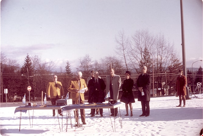
- Photograph of officials gathered for Burnaby Centennial '71 New Year's Day ceremony outside of Burnaby Municipal Hal. Centennial flags are layed out onto two tables. Burnaby Centennial Committee member and master of ceremonies Sandy Stewart is speaking at the microphone. Officials standing behind h…
- Repository
- Burnaby Village Museum
- Collection/Fonds
- Donald Copan collection
- Series
- Copan album series
- Description Level
- Item
- Physical Description
- 1 photograph : col. ; 8.9 x 12.7 cm
- Scope and Content
- Photograph of officials gathered for Burnaby Centennial '71 New Year's Day ceremony outside of Burnaby Municipal Hal. Centennial flags are layed out onto two tables. Burnaby Centennial Committee member and master of ceremonies Sandy Stewart is speaking at the microphone. Officials standing behind him include; Burnaby Centennial '71 chair James Barrington, Monsignor Brown, Member of Legislative Assembly Mr. Jim Lorimer and Burnaby Centennial '71 Committee co-ordinator Mary Trainer.The ground is covered in snow. identified include;
- Subjects
- Celebrations - Centennials
- Officials - Aldermen and Councillors
- Officials - Mayors and Reeves
- Names
- Barrington, James Alfred "Jim"
- Stewart, A.B. "Sandy"
- Lorimer, James G "Jim"
- Brown, Monsignor
- Trainer, Mary
- Geographic Access
- Canada Way
- Street Address
- 4949 Canada Way
- Accession Code
- BV005.54.538
- Access Restriction
- No restrictions
- Reproduction Restriction
- May be restricted by third party rights
- Date
- 1 Jan 1971
- Media Type
- Photograph
- Historic Neighbourhood
- Burnaby Lake (Historic Neighbourhood)
- Planning Study Area
- Douglas-Gilpin Area
- Scan Resolution
- 600
- Scan Date
- August 11, 2020
- Scale
- 100
- Notes
- Title based on contents of photograph
Images
Burnaby Firemens Band at Burnaby Centennial '71 New Year's Day Ceremony
https://search.heritageburnaby.ca/link/museumdescription13648
- Repository
- Burnaby Village Museum
- Date
- 1 Jan 1971
- Collection/Fonds
- Donald Copan collection
- Description Level
- Item
- Physical Description
- 1 photograph : col. ; 8.9 x 12.7 cm
- Scope and Content
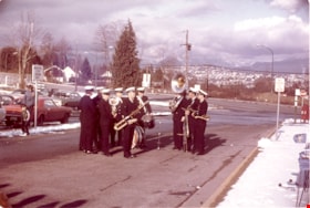
- Photograph of Burnaby Firemens Band at Burnaby Centennial '71 New Year's Day Ceremony outside of Burnaby Municipal Hall for the Centennial year kick-off.
- Repository
- Burnaby Village Museum
- Collection/Fonds
- Donald Copan collection
- Series
- Copan album series
- Description Level
- Item
- Physical Description
- 1 photograph : col. ; 8.9 x 12.7 cm
- Scope and Content
- Photograph of Burnaby Firemens Band at Burnaby Centennial '71 New Year's Day Ceremony outside of Burnaby Municipal Hall for the Centennial year kick-off.
- Geographic Access
- Canada Way
- Street Address
- 4949 Canada Way
- Accession Code
- BV005.54.543
- Access Restriction
- No restrictions
- Reproduction Restriction
- May be restricted by third party rights
- Date
- 1 Jan 1971
- Media Type
- Photograph
- Historic Neighbourhood
- Burnaby Lake (Historic Neighbourhood)
- Planning Study Area
- Douglas-Gilpin Area
- Scan Resolution
- 600
- Scan Date
- August 11, 2020
- Scale
- 100
- Notes
- Title based on contents of photograph
Images

Burnaby Princesses and Miss Burnaby at Port Coquitlam May Day
https://search.heritageburnaby.ca/link/museumdescription19108
- Repository
- Burnaby Village Museum
- Date
- 1970
- Collection/Fonds
- Denise Dullum fonds
- Description Level
- Item
- Physical Description
- 1 photograph : col. print ; 10 x 15 cm
- Scope and Content
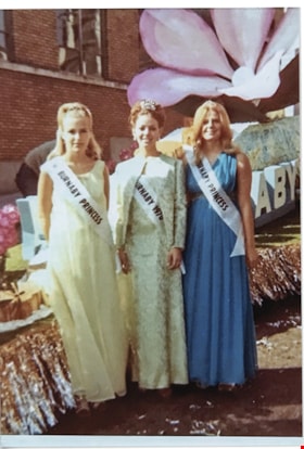
- Photograph of Burnaby Princess Veronica Porter (left), Miss Burnaby, Melodie Spring (middle) and Burnaby Princess, Denise Dullum (nee Fouchard) at Port Coquitlam May Day. The three are standing in front of a Burnaby parade float. Veronica Porter is wearing a long white dress and Denise Dullum (nee …
- Repository
- Burnaby Village Museum
- Collection/Fonds
- Denise Dullum fonds
- Description Level
- Item
- Physical Description
- 1 photograph : col. print ; 10 x 15 cm
- Scope and Content
- Photograph of Burnaby Princess Veronica Porter (left), Miss Burnaby, Melodie Spring (middle) and Burnaby Princess, Denise Dullum (nee Fouchard) at Port Coquitlam May Day. The three are standing in front of a Burnaby parade float. Veronica Porter is wearing a long white dress and Denise Dullum (nee Fouchard) is wearing a long blue dress, each is wearing a white satin sash draped across from their shoulder to their opposing hip reading “BURNABY PRINCESS”. Melodie Spring is wearing a gold floral brocade dress with a white satin sash draped fronm her shoulder to her opposing hip reading “MISS BURNABY 1970”. Melodie Spring, Denise Dullum and Veronica Porter were contestants in the Miss Burnaby contest in 1970.
- Subjects
- Events - Parades
- Accession Code
- BV022.23.1
- Access Restriction
- No restrictions
- Reproduction Restriction
- May be restricted by third party rights
- Date
- 1970
- Media Type
- Photograph
- Scan Resolution
- 600
- Notes
- Title based on contents of photograph
Images

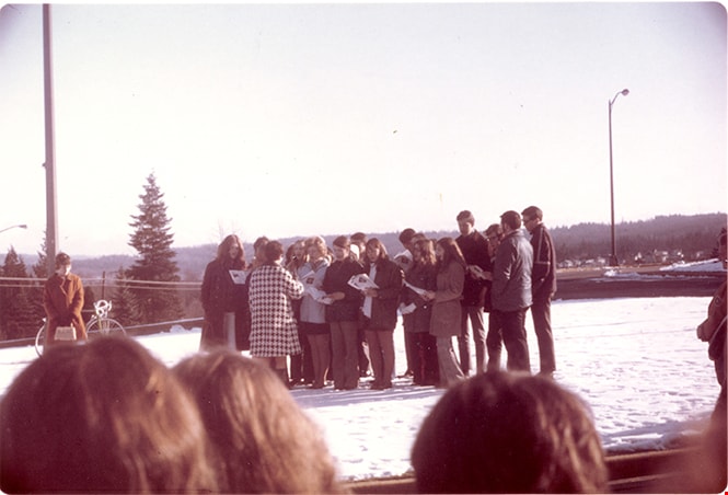
Burnaby South Secondary School choir performing outside of Burnaby Municipal Hall
https://search.heritageburnaby.ca/link/museumdescription13642
- Repository
- Burnaby Village Museum
- Date
- 1 Jan 1971
- Collection/Fonds
- Donald Copan collection
- Description Level
- Item
- Physical Description
- 1 photograph : col. ; 8.9 x 12.7 cm
- Scope and Content
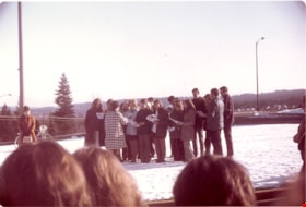
- Photograph of Burnaby South Secondary School choir performing outside on the lawn of Burnaby Municipal Hall during the Burnaby Centennial '71 New Year's Day Ceremony. The ground is covered in snow.
- Repository
- Burnaby Village Museum
- Collection/Fonds
- Donald Copan collection
- Series
- Copan album series
- Description Level
- Item
- Physical Description
- 1 photograph : col. ; 8.9 x 12.7 cm
- Scope and Content
- Photograph of Burnaby South Secondary School choir performing outside on the lawn of Burnaby Municipal Hall during the Burnaby Centennial '71 New Year's Day Ceremony. The ground is covered in snow.
- Geographic Access
- Canada Way
- Street Address
- 4949 Canada Way
- Accession Code
- BV005.54.537
- Access Restriction
- No restrictions
- Reproduction Restriction
- May be restricted by third party rights
- Date
- 1 Jan 1971
- Media Type
- Photograph
- Historic Neighbourhood
- Burnaby Lake (Historic Neighbourhood)
- Planning Study Area
- Douglas-Gilpin Area
- Scan Resolution
- 600
- Scan Date
- August 11, 2020
- Scale
- 100
- Notes
- Title based on contents of photograph
Images

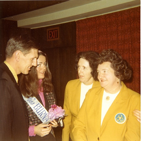
Members of Burnaby Centennial '71 Committee and Miss Burnaby
https://search.heritageburnaby.ca/link/museumdescription13366
- Repository
- Burnaby Village Museum
- Date
- 19 November 1971
- Collection/Fonds
- Donald Copan collection
- Description Level
- Item
- Physical Description
- 1 photograph : col. ; 8.9 x 8.9 cm
- Scope and Content
- Photograph of Burnaby Centennial '71 Committee members speaking with Miss Burnaby (Sheila Nicholson) and an unidentified man during a civic luncheon at the Astor Hotel. The luncheon followed the official opening ceremony of Heritage Village. Burnaby Centennial '71 Committee vice chair Rose Bancrof…
- Repository
- Burnaby Village Museum
- Collection/Fonds
- Donald Copan collection
- Series
- Copan album series
- Description Level
- Item
- Physical Description
- 1 photograph : col. ; 8.9 x 8.9 cm
- Scope and Content
- Photograph of Burnaby Centennial '71 Committee members speaking with Miss Burnaby (Sheila Nicholson) and an unidentified man during a civic luncheon at the Astor Hotel. The luncheon followed the official opening ceremony of Heritage Village. Burnaby Centennial '71 Committee vice chair Rose Bancroft is on the right.
- Accession Code
- BV005.54.387
- Access Restriction
- No restrictions
- Reproduction Restriction
- May be restricted by third party rights
- Date
- 19 November 1971
- Media Type
- Photograph
- Scan Resolution
- 600
- Scan Date
- 4-Aug-2020
- Scale
- 100
- Notes
- Title based on contents of photograph
Images
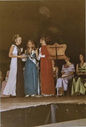
Miss Burnaby and Burnaby Princesses of 1970`
https://search.heritageburnaby.ca/link/museumdescription19118
- Repository
- Burnaby Village Museum
- Date
- 1971
- Collection/Fonds
- Denise Dullum fonds
- Description Level
- Item
- Physical Description
- 1 photograph : col. print ; 15 x 10 cm
- Scope and Content
- Photograph of Burnaby Princesses of 1970, Denise Dullum (nee Fouchard) (middle) and Veronica Porter (left) standing together on stage with Miss Burnaby of 1970, Melodie Spring (right) during the 1971 Miss Burnaby Pageant. The event is taking place in the James Cowan Theatre. The three winners from …
- Repository
- Burnaby Village Museum
- Collection/Fonds
- Denise Dullum fonds
- Description Level
- Item
- Physical Description
- 1 photograph : col. print ; 15 x 10 cm
- Scope and Content
- Photograph of Burnaby Princesses of 1970, Denise Dullum (nee Fouchard) (middle) and Veronica Porter (left) standing together on stage with Miss Burnaby of 1970, Melodie Spring (right) during the 1971 Miss Burnaby Pageant. The event is taking place in the James Cowan Theatre. The three winners from the 1970 Miss Burnaby Pageant are getting ready to deliver farewell speeches and pass on crowns and sashes to the winners in the 1971 Miss Burnaby pageant. 1971 contestants are seated on the stage behind them.
- Accession Code
- BV022.23.11
- Access Restriction
- No restrictions
- Reproduction Restriction
- May be restricted by third party rights
- Date
- 1971
- Media Type
- Photograph
- Scan Resolution
- 600
- Notes
- Title based on contents of photograph
Images
