More like 'London mixer and contractors'
Narrow Results By
Decade
- 2020s 127
- 2010s 72
- 2000s 736
- 1990s 645
- 1980s
- 1970s 1021
- 1960s 489
- 1950s 652
- 1940s 684
- 1930s
- 1920s 602
- 1910s 657
- 1900s 264
- 1890s 48
- 1880s 53
- 1870s 5
- 1860s 3
- 1850s 2
- 1840s 1
- 1830s 1
- 1820s 1
- 1810s 2
- 1800s 2
- 1790s 2
- 1780s 2
- 1770s 2
- 1760s 2
- 1750s 2
- 1740s 2
- 1730s 2
- 1720s 2
- 1710s 2
- 1700s 2
- 1690s 2
- 1680s 2
- 1670s 2
- 1660s 2
- 1650s 2
- 1640s 2
- 1630s 2
- 1620s 2
- 1610s
- 1600s 2
- 1590s 1
- 1580s 1
- 1570s 1
- 1560s 1
- 1550s 1
- 1540s 1
- 1530s 1
- 1520s 1
- 1510s 1
- 1500s 1
- 1490s 1
- 1480s 1
Subject
- Accidents - Train Accidents 8
- Advertising Medium - Signs and Signboards 8
- Agricultural Tools and Equipment 2
- Agricultural Tools and Equipment - Gardening Equipment 4
- Agricultural Tools and Equipment - Plows 1
- Agriculture 2
- Agriculture - Crops 2
- Agriculture - Dairy 1
- Agriculture - Farms 13
- Animals 3
- Animals - Dogs 9
- Animals - Horses 8

Duncan & Margaret McGregor Estate 'Glen-Lyon' New Haven Barn
https://search.heritageburnaby.ca/link/landmark852
- Repository
- Burnaby Heritage Planning
- Description
- Designed in a vernacular architectural style, the New Haven Barn is a large gambrel-roofed barn located on the Edwardian era McGregor Estate 'Glen-Lyon,' overlooking the rich farmland of the Fraser River floodplain and near a ravine and forested area adjacent to Marine Drive in South Burnaby.
- Associated Dates
- 1939
- Formal Recognition
- Heritage Designation, Community Heritage Register
- Other Names
- Home of the Friendless, New Haven Borstal Home for Boys and Youthful Offenders, New Haven Correction Centre
- Street View URL
- Google Maps Street View
- Repository
- Burnaby Heritage Planning
- Other Names
- Home of the Friendless, New Haven Borstal Home for Boys and Youthful Offenders, New Haven Correction Centre
- Geographic Access
- Marine Drive
- Associated Dates
- 1939
- Formal Recognition
- Heritage Designation, Community Heritage Register
- Enactment Type
- Bylaw No. 12183
- Enactment Date
- 11/12/2006
- Description
- Designed in a vernacular architectural style, the New Haven Barn is a large gambrel-roofed barn located on the Edwardian era McGregor Estate 'Glen-Lyon,' overlooking the rich farmland of the Fraser River floodplain and near a ravine and forested area adjacent to Marine Drive in South Burnaby.
- Heritage Value
- The site is historically significant for its association with early social welfare and correctional reform. The estate was sold in 1926 to an inter-denominational religious organization called the Home of the Friendless, which used it as their B.C. headquarters. The organization was charged with several cases of abuse and neglect in 1937, after which a Royal Commission was formed that led to new legislation to regulate and license all private welfare institutions. 'Glen-Lyon' was sold to the provincial government, and was dedicated in 1939 by the Lt.-Gov. E.W. Hamber for use as the New Haven Borstal Home for Boys and Youthful Offenders (later renamed the New Haven Correction Centre). The Borstal movement originated in England in the late nineteenth century, as an alternative to sending young offenders and runaways to prisons by providing reformatories that focused on discipline and vocational skill. This site’s role as the first North American institution devoted to the Borstal School philosophy was historic, and influenced corrections programs across Canada. The New Haven Barn is a significant feature from its development in 1939 as the Borstal School, designed by Chief Provincial Architect Henry Whittaker of the Department of Public Works, and is the only remaining structure of its kind in Burnaby.
- Defining Elements
- Key elements that define the heritage character of the New Haven Barn include its: - gambrel-roofed barn with roof vent with finial, sliding hay loft and access doors, small multi-pane windows, and lapped wooden siding
- Historic Neighbourhood
- Fraser Arm (Historic Neighbourhood)
- Planning Study Area
- Big Bend Area
- Architect
- Henry Whittaker
- Function
- Primary Historic--Estate
- Community
- Burnaby
- Cadastral Identifier
- 003-004-661
- Boundaries
- 'Glen-Lyon' is comprised of a single residential lot located at 4250 Marine Drive, Burnaby.
- Area
- 230873.18
- Contributing Resource
- Building
- Ownership
- Private
- Names
- Whittaker, George
- New Haven Borstal Home for Boys and Youthful Offenders
- New Haven Correction Centre
- Borstal School
- Street Address
- 4250 Marine Drive
- Street View URL
- Google Maps Street View
Images


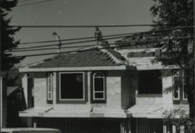
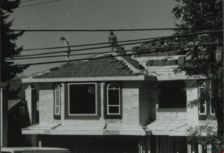
6742 Walker Avenue construction
https://search.heritageburnaby.ca/link/archivedescription37859
- Repository
- City of Burnaby Archives
- Date
- 1987 (date of original), copied 1991
- Collection/Fonds
- Burnaby Historical Society fonds
- Description Level
- Item
- Physical Description
- 1 photograph : b&w ; 3.1 x 4.4 cm print on contact sheet 20.4 x 26.7 cm
- Scope and Content
- Photograph of the construction of a house at 6742 Walker Avenue. Roofing is being done in the summer of 1987. Two men are standing on the roof.
- Repository
- City of Burnaby Archives
- Date
- 1987 (date of original), copied 1991
- Collection/Fonds
- Burnaby Historical Society fonds
- Subseries
- Burnaby Image Bank subseries
- Physical Description
- 1 photograph : b&w ; 3.1 x 4.4 cm print on contact sheet 20.4 x 26.7 cm
- Description Level
- Item
- Record No.
- 370-447
- Access Restriction
- No restrictions
- Reproduction Restriction
- No restrictions
- Accession Number
- BHS1999-03
- Scope and Content
- Photograph of the construction of a house at 6742 Walker Avenue. Roofing is being done in the summer of 1987. Two men are standing on the roof.
- Media Type
- Photograph
- Notes
- Title based on contents of photograph
- 1 b&w copy negative accompanying
- Negative has a pink cast
- Copied from col. photograph
- Geographic Access
- Walker Avenue
- Street Address
- 6742 Walker Avenue
- Historic Neighbourhood
- Edmonds (Historic Neighbourhood)
- Planning Study Area
- Richmond Park Area
Images
![Bellinger family home, [1936 or 1937] (date of original), copied 1991 thumbnail](/media/hpo/_Data/_Archives_Images/_Unrestricted/370/370-048.jpg?width=280)
Bellinger family home
https://search.heritageburnaby.ca/link/archivedescription37460
- Repository
- City of Burnaby Archives
- Date
- [1936 or 1937] (date of original), copied 1991
- Collection/Fonds
- Burnaby Historical Society fonds
- Description Level
- Item
- Physical Description
- 1 photograph : b&w ; 2.8 x 4.1 cm print on contact sheet 20.2 x 25.3 cm
- Scope and Content
- Photograph of the Bellinger family home at 2827 Earl Avenue (later 6296 Pearl Avenue), during alteration of the front porch. The workers are unidentified.
- Repository
- City of Burnaby Archives
- Date
- [1936 or 1937] (date of original), copied 1991
- Collection/Fonds
- Burnaby Historical Society fonds
- Subseries
- Burnaby Image Bank subseries
- Physical Description
- 1 photograph : b&w ; 2.8 x 4.1 cm print on contact sheet 20.2 x 25.3 cm
- Description Level
- Item
- Record No.
- 370-048
- Access Restriction
- No restrictions
- Reproduction Restriction
- No known restrictions
- Accession Number
- BHS1999-03
- Scope and Content
- Photograph of the Bellinger family home at 2827 Earl Avenue (later 6296 Pearl Avenue), during alteration of the front porch. The workers are unidentified.
- Media Type
- Photograph
- Photographer
- Bellinger, Bernard
- Notes
- Title based on contents of photograph
- 1 b&w copy negative accompanying
- Photos 370-047 and 370-049 show house before and after renovations
- Geographic Access
- Pearl Avenue
- Street Address
- 6296 Pearl Avenue
- Historic Neighbourhood
- Central Park (Historic Neighbourhood)
- Planning Study Area
- Windsor Area
Images
![Bellinger family home, [1936 or 1937] (date of original), copied 1991 thumbnail](/media/hpo/_Data/_Archives_Images/_Unrestricted/370/370-048.jpg)
Construction at 4674 Southlawn Drive
https://search.heritageburnaby.ca/link/archivedescription37892
- Repository
- City of Burnaby Archives
- Date
- 1987 (date of original), copied 1991
- Collection/Fonds
- Burnaby Historical Society fonds
- Description Level
- Item
- Physical Description
- 1 photograph : b&w ; 3.0 x 3.0 cm print on contact sheet 20.4 x 26.9 cm
- Scope and Content
- Photograph of the renovation and construction at 4674 Southlawn Drive, with the front of the house.
- Repository
- City of Burnaby Archives
- Date
- 1987 (date of original), copied 1991
- Collection/Fonds
- Burnaby Historical Society fonds
- Subseries
- Burnaby Image Bank subseries
- Physical Description
- 1 photograph : b&w ; 3.0 x 3.0 cm print on contact sheet 20.4 x 26.9 cm
- Description Level
- Item
- Record No.
- 370-480
- Access Restriction
- No restrictions
- Reproduction Restriction
- No restrictions
- Accession Number
- BHS1999-03
- Scope and Content
- Photograph of the renovation and construction at 4674 Southlawn Drive, with the front of the house.
- Media Type
- Photograph
- Notes
- Title based on contents of photograph
- 1 b&w copy negative accompanying
- Negative has a pink cast
- Copied from col. photograph
- Geographic Access
- Southlawn Drive
- Street Address
- 4674 Southlawn Drive
- Planning Study Area
- Brentwood Area
Images

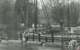
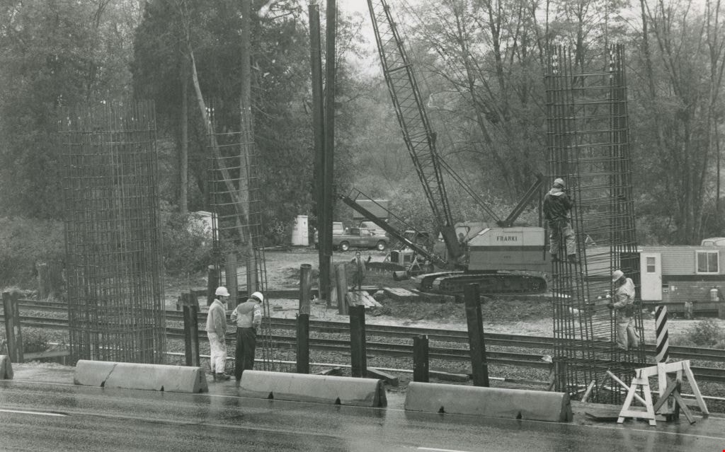
Construction workers
https://search.heritageburnaby.ca/link/archivedescription59066
- Repository
- City of Burnaby Archives
- Date
- ca.1983
- Collection/Fonds
- Columbian Newspaper collection
- Description Level
- Item
- Physical Description
- 1 photograph : b&w ; 17 x 25.5 cm
- Scope and Content
- Photograph of construction workers erecting steel frames next to railway tracks. Cranes and other construction vehicles are in the background.
- Repository
- City of Burnaby Archives
- Date
- ca.1983
- Collection/Fonds
- Columbian Newspaper collection
- Physical Description
- 1 photograph : b&w ; 17 x 25.5 cm
- Description Level
- Item
- Record No.
- 480-1472
- Access Restriction
- No restrictions
- Reproduction Restriction
- Reproduce for fair dealing purposes only
- Accession Number
- 2009-01
- Scope and Content
- Photograph of construction workers erecting steel frames next to railway tracks. Cranes and other construction vehicles are in the background.
- Media Type
- Photograph
- Photographer
- Hodge, Craig
- Notes
- Title based on contents of photograph
- Photographer's stamp on verso
- Note on verso reads: "PMT 100% / Page 4 / Burnaby / Today"
Images

1982 - Moving the Roberts House
https://search.heritageburnaby.ca/link/archivedescription91884
- Repository
- City of Burnaby Archives
- Date
- 1982
- Collection/Fonds
- Small family fonds
- Description Level
- Item
- Physical Description
- 1 photograph : col. ; 10 cm x 15 cm
- Scope and Content
- Photograph of the Roberts' house being moved from 5538 Dominion Street to 5496 Dominion Street. Wheels were attached to both ends of the iron beams supporting the raised house and one set of wheels was attached to a swivel on a flatbed truck to facilitate the move. The furnishings and appliances …
- Repository
- City of Burnaby Archives
- Date
- 1982
- Collection/Fonds
- Small family fonds
- Physical Description
- 1 photograph : col. ; 10 cm x 15 cm
- Description Level
- Item
- Record No.
- 620-065
- Access Restriction
- No restrictions
- Reproduction Restriction
- No reproduction permitted
- Accession Number
- 2017-01
- Scope and Content
- Photograph of the Roberts' house being moved from 5538 Dominion Street to 5496 Dominion Street. Wheels were attached to both ends of the iron beams supporting the raised house and one set of wheels was attached to a swivel on a flatbed truck to facilitate the move. The furnishings and appliances were left inside the house during the move.
- Media Type
- Photograph
- Notes
- Transcribed title
- Title transcribed from donor's notes
- Note in blue ink on verso of photograph reads: "P7"
- Note in black ink on verso of photograph reads: "7"
- Note in pencil on verso of photograph reads: "6"
- Street Address
- 5538 Dominion Street
- 5496 Dominion Street
- Historic Neighbourhood
- Burnaby Lake (Historic Neighbourhood)
- Planning Study Area
- Ardingley-Sprott Area
Images


1982 - Moving the Roberts House
https://search.heritageburnaby.ca/link/archivedescription91885
- Repository
- City of Burnaby Archives
- Date
- September 1982
- Collection/Fonds
- Small family fonds
- Description Level
- Item
- Physical Description
- 1 photograph : col. ; 10 cm x 15 cm
- Scope and Content
- Photograph of the Roberts' house being moved from 5538 Dominion Street to 5496 Dominion Street. Wheels were attached to both ends of the iron beams supporting the raised house and one set wheels was attached to a swivel on a flatbed truck to facilitate the move. The house was turned 90 degrees so…
- Repository
- City of Burnaby Archives
- Date
- September 1982
- Collection/Fonds
- Small family fonds
- Physical Description
- 1 photograph : col. ; 10 cm x 15 cm
- Description Level
- Item
- Record No.
- 620-066
- Access Restriction
- No restrictions
- Reproduction Restriction
- No reproduction permitted
- Accession Number
- 2017-01
- Scope and Content
- Photograph of the Roberts' house being moved from 5538 Dominion Street to 5496 Dominion Street. Wheels were attached to both ends of the iron beams supporting the raised house and one set wheels was attached to a swivel on a flatbed truck to facilitate the move. The house was turned 90 degrees so that it faced Dominion Street.
- Media Type
- Photograph
- Notes
- Transcribed title
- Title transcribed from donor's notes
- Note in blue ink on verso of photograph reads: "P.8"
- Note in black ink on verso of photograph reads: "8"
- Note in pencil on verso of photograph reads: "7"
- Note in black ink on verso of photograph reads: "Moving and Turning 90 [degrees] / Sept. 82"
- Street Address
- 5538 Dominion Street
- 5496 Dominion Street
- Historic Neighbourhood
- Burnaby Lake (Historic Neighbourhood)
- Planning Study Area
- Ardingley-Sprott Area
Images


1982 - Moving the Roberts House
https://search.heritageburnaby.ca/link/archivedescription91886
- Repository
- City of Burnaby Archives
- Date
- 1982
- Collection/Fonds
- Small family fonds
- Description Level
- Item
- Physical Description
- 1 photograph : col. ; 10 cm x 15 cm
- Scope and Content
- Photograph of the Roberts' house nearly in its new position after being moved from 5538 Dominion Street to 5496 Dominion Street. The move took nearly two full days to complete.
- Repository
- City of Burnaby Archives
- Date
- 1982
- Collection/Fonds
- Small family fonds
- Physical Description
- 1 photograph : col. ; 10 cm x 15 cm
- Description Level
- Item
- Record No.
- 620-067
- Access Restriction
- No restrictions
- Reproduction Restriction
- No reproduction permitted
- Accession Number
- 2017-01
- Scope and Content
- Photograph of the Roberts' house nearly in its new position after being moved from 5538 Dominion Street to 5496 Dominion Street. The move took nearly two full days to complete.
- Media Type
- Photograph
- Notes
- Transcribed title
- Title transcribed from donor's notes
- Note in blue ink on verso of photograph reads: "P9"
- Note in black ink on verso of photograph reads: "25"
- Note in pencil on verso of photograph reads: "8"
- Street Address
- 5538 Dominion Street
- 5496 Dominion Street
- Historic Neighbourhood
- Burnaby Lake (Historic Neighbourhood)
- Planning Study Area
- Ardingley-Sprott Area
Images


1982 - Moving the Roberts House
https://search.heritageburnaby.ca/link/archivedescription91887
- Repository
- City of Burnaby Archives
- Date
- September 1982
- Collection/Fonds
- Small family fonds
- Description Level
- Item
- Physical Description
- 1 photograph : col. ; 10 cm x 15 cm
- Scope and Content
- Photograph of the Roberts' house in its new position at 5496 Dominion Street. The house is jacked up and sitting on block to enable workers to build forms and pour concrete for the foundation walls.
- Repository
- City of Burnaby Archives
- Date
- September 1982
- Collection/Fonds
- Small family fonds
- Physical Description
- 1 photograph : col. ; 10 cm x 15 cm
- Description Level
- Item
- Record No.
- 620-068
- Access Restriction
- No restrictions
- Reproduction Restriction
- No reproduction permitted
- Accession Number
- 2017-01
- Scope and Content
- Photograph of the Roberts' house in its new position at 5496 Dominion Street. The house is jacked up and sitting on block to enable workers to build forms and pour concrete for the foundation walls.
- Media Type
- Photograph
- Notes
- Transcribed title
- Title transcribed from donor's notes
- Note in blue ink on verso of photograph reads: "P.10"
- Note in black ink on verso of photograph reads: "15"
- Note in pencil on verso of photograph reads: "9"
- Note in black ink on verso of photograph reads: "Moving the house / Foundation Built, Waterproofed and Drainage Installed. / Sept. 82"
- Street Address
- 5496 Dominion Street
- Historic Neighbourhood
- Burnaby Lake (Historic Neighbourhood)
- Planning Study Area
- Ardingley-Sprott Area
Images


1982 - Moving the Roberts House
https://search.heritageburnaby.ca/link/archivedescription91891
- Repository
- City of Burnaby Archives
- Date
- 1982
- Collection/Fonds
- Small family fonds
- Description Level
- Item
- Physical Description
- 1 photograph : col. ; 10 cm x 15 cm
- Scope and Content
- Photograph of an excavator clearing the land between 5496 Dominion Street and Douglas Road. The three lots in this area were subdivided into six 33 foot lots and cleared for the construction of six new houses.
- Repository
- City of Burnaby Archives
- Date
- 1982
- Collection/Fonds
- Small family fonds
- Physical Description
- 1 photograph : col. ; 10 cm x 15 cm
- Description Level
- Item
- Record No.
- 620-072
- Access Restriction
- No restrictions
- Reproduction Restriction
- No reproduction permitted
- Accession Number
- 2017-01
- Scope and Content
- Photograph of an excavator clearing the land between 5496 Dominion Street and Douglas Road. The three lots in this area were subdivided into six 33 foot lots and cleared for the construction of six new houses.
- Media Type
- Photograph
- Notes
- Transcribed title
- Title transcribed from donor's notes
- Note in blue ink on verso of photograph reads: "P.14"
- Note in pencil on verso of photograph reads: "13"
- Street Address
- 5496 Dominion Street
- Historic Neighbourhood
- Burnaby Lake (Historic Neighbourhood)
- Planning Study Area
- Ardingley-Sprott Area
Images


1982 - Moving the Roberts House
https://search.heritageburnaby.ca/link/archivedescription91892
- Repository
- City of Burnaby Archives
- Date
- 1982
- Collection/Fonds
- Small family fonds
- Description Level
- Item
- Physical Description
- 1 photograph : col. ; 15 cm x 10 cm
- Scope and Content
- Photograph of a labourer removing the old foundation and boulders from the 5496 Dominion Street property with a jackhammer. The house located at 5511 Norfolk Street is visible in the background.
- Repository
- City of Burnaby Archives
- Date
- 1982
- Collection/Fonds
- Small family fonds
- Physical Description
- 1 photograph : col. ; 15 cm x 10 cm
- Description Level
- Item
- Record No.
- 620-073
- Access Restriction
- No restrictions
- Reproduction Restriction
- No reproduction permitted
- Accession Number
- 2017-01
- Scope and Content
- Photograph of a labourer removing the old foundation and boulders from the 5496 Dominion Street property with a jackhammer. The house located at 5511 Norfolk Street is visible in the background.
- Media Type
- Photograph
- Notes
- Transcribed title
- Title transcribed from donor's notes
- Note in blue ink on verso of photograph reads: "P.15"
- Note in pencil on verso of photograph reads: "14"
- 5511 Norfolk Street was previously numbered 3149 Norfolk Street. It was later subdivided into two lots: 5503 and 5521 Norfolk Street.
- Street Address
- 5511 Norfolk Street
- 5496 Dominion Street
- Historic Neighbourhood
- Burnaby Lake (Historic Neighbourhood)
- Planning Study Area
- Ardingley-Sprott Area
Images


Former site of the Kelly Douglas building
https://search.heritageburnaby.ca/link/archivedescription35027
- Repository
- City of Burnaby Archives
- Date
- August 18, 1986
- Collection/Fonds
- Burnaby Historical Society fonds
- Description Level
- Item
- Physical Description
- 1 photograph : col. ; 8.8 x 12.6 cm
- Scope and Content
- Photograph of the site of Kelly Douglas and Co. at 4700 Kingsway after the building was demolished. A bulldozer and a large truck with two men standing on it are at the back left of the photograph.
- Repository
- City of Burnaby Archives
- Date
- August 18, 1986
- Collection/Fonds
- Burnaby Historical Society fonds
- Subseries
- Evelyn Salisbury subseries
- Physical Description
- 1 photograph : col. ; 8.8 x 12.6 cm
- Material Details
- Printed on verso of photograph: "This paper manufactured by Kodak"
- Description Level
- Item
- Record No.
- 178-001
- Access Restriction
- No restrictions
- Reproduction Restriction
- Reproduce for fair dealing purposes only
- Accession Number
- BHS1986-26
- Scope and Content
- Photograph of the site of Kelly Douglas and Co. at 4700 Kingsway after the building was demolished. A bulldozer and a large truck with two men standing on it are at the back left of the photograph.
- Media Type
- Photograph
- Notes
- Title based on contents of photograph
- Geographic Access
- Kingsway
- Street Address
- 4700 Kingsway
- Historic Neighbourhood
- Central Park (Historic Neighbourhood)
- Planning Study Area
- Maywood Area
Images

![George Pearson, [193-?] (date of original), copied 1986 thumbnail](/media/hpo/_Data/_Archives_Images/_Unrestricted/204/204-035.jpg?width=280)
George Pearson
https://search.heritageburnaby.ca/link/archivedescription35178
- Repository
- City of Burnaby Archives
- Date
- [193-?] (date of original), copied 1986
- Collection/Fonds
- Burnaby Historical Society fonds
- Description Level
- Item
- Physical Description
- 1 photograph : b&w ; 12.7 x 17.8 cm print
- Scope and Content
- Photograph of a man identified as George Pearson digging a foundation with a pick and shovel at the Burnaby Municipal Hall site at Kingsway and Edmonds Street. Note the Municipal Hall in the background.
- Repository
- City of Burnaby Archives
- Date
- [193-?] (date of original), copied 1986
- Collection/Fonds
- Burnaby Historical Society fonds
- Subseries
- Pioneer Tales subseries
- Physical Description
- 1 photograph : b&w ; 12.7 x 17.8 cm print
- Description Level
- Item
- Record No.
- 204-035
- Access Restriction
- No restrictions
- Reproduction Restriction
- No known restrictions
- Accession Number
- BHS1988-03
- Scope and Content
- Photograph of a man identified as George Pearson digging a foundation with a pick and shovel at the Burnaby Municipal Hall site at Kingsway and Edmonds Street. Note the Municipal Hall in the background.
- Media Type
- Photograph
- Notes
- Title based on contents of photograph
- Geographic Access
- Kingsway
- Street Address
- 7282 Kingsway
- Historic Neighbourhood
- Edmonds (Historic Neighbourhood)
- Planning Study Area
- Stride Avenue Area
Images
![George Pearson, [193-?] (date of original), copied 1986 thumbnail](/media/hpo/_Data/_Archives_Images/_Unrestricted/204/204-035.jpg)
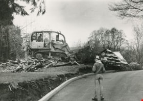
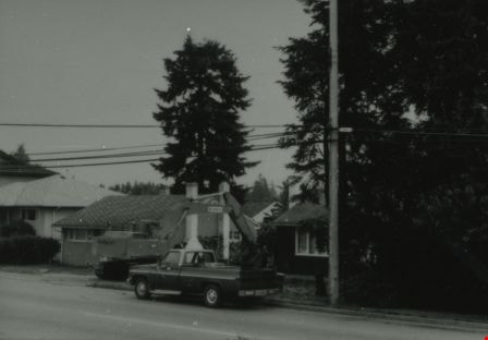
Lillian Mann's former property
https://search.heritageburnaby.ca/link/archivedescription46243
- Repository
- City of Burnaby Archives
- Date
- March 30, 1983
- Collection/Fonds
- Columbian Newspaper collection
- Description Level
- Item
- Physical Description
- 1 photograph : b&w ; 17.5 x 24.5 cm
- Scope and Content
- Photograph of private demolition crew leveling Lillian Mann's home with a bulldozer as a teenager looks on.
- Repository
- City of Burnaby Archives
- Date
- March 30, 1983
- Collection/Fonds
- Columbian Newspaper collection
- Physical Description
- 1 photograph : b&w ; 17.5 x 24.5 cm
- Description Level
- Item
- Record No.
- 480-1131
- Access Restriction
- No restrictions
- Reproduction Restriction
- No restrictions
- Accession Number
- 2003-02
- Scope and Content
- Photograph of private demolition crew leveling Lillian Mann's home with a bulldozer as a teenager looks on.
- Media Type
- Photograph
- Photographer
- King, Basil
- Notes
- Title based on contents of photograph
- Note on recto of photograph reads: "The END of LILLIAN MANN"
- Geographic Access
- Cameron Street
- Historic Neighbourhood
- Burquitlam (Historic Neighbourhood)
- Planning Study Area
- Lyndhurst Area
Images

6742 Walker Avenue demolition
https://search.heritageburnaby.ca/link/archivedescription37847
- Repository
- City of Burnaby Archives
- Date
- June 5, 1987 (date of original), copied 1991
- Collection/Fonds
- Burnaby Historical Society fonds
- Description Level
- Item
- Physical Description
- 1 photograph : b&w ; 3.0 x 4.4 cm print on contact sheet 20.6 x 26.7 cm
- Scope and Content
- Photograph of a truck and back hoe at 6742 Walker Avenue at 7:30am on June 5, 1987. The house in in the process of being demolished.
- Repository
- City of Burnaby Archives
- Date
- June 5, 1987 (date of original), copied 1991
- Collection/Fonds
- Burnaby Historical Society fonds
- Subseries
- Burnaby Image Bank subseries
- Physical Description
- 1 photograph : b&w ; 3.0 x 4.4 cm print on contact sheet 20.6 x 26.7 cm
- Description Level
- Item
- Record No.
- 370-435
- Access Restriction
- No restrictions
- Reproduction Restriction
- No restrictions
- Accession Number
- BHS1999-03
- Scope and Content
- Photograph of a truck and back hoe at 6742 Walker Avenue at 7:30am on June 5, 1987. The house in in the process of being demolished.
- Media Type
- Photograph
- Notes
- Title based on contents of photograph
- 1 b&w copy negative accompanying
- Negative has a pink cast
- Copied from col. photograph
- Geographic Access
- Walker Avenue
- Street Address
- 6742 Walker Avenue
- Historic Neighbourhood
- Edmonds (Historic Neighbourhood)
- Planning Study Area
- Richmond Park Area
Images

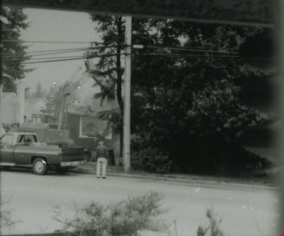
6742 Walker Avenue demolition
https://search.heritageburnaby.ca/link/archivedescription37848
- Repository
- City of Burnaby Archives
- Date
- June 5, 1987 (date of original), copied 1991
- Collection/Fonds
- Burnaby Historical Society fonds
- Description Level
- Item
- Physical Description
- 1 photograph : b&w ; 3.0 x 4.4 cm print on contact sheet 20.6 x 26.7 cm
- Scope and Content
- Photograph of a truck and back hoe at 6742 Walker Avenue on June 5, 1987. The house in in the process of being demolished and a man is looking on.
- Repository
- City of Burnaby Archives
- Date
- June 5, 1987 (date of original), copied 1991
- Collection/Fonds
- Burnaby Historical Society fonds
- Subseries
- Burnaby Image Bank subseries
- Physical Description
- 1 photograph : b&w ; 3.0 x 4.4 cm print on contact sheet 20.6 x 26.7 cm
- Description Level
- Item
- Record No.
- 370-436
- Access Restriction
- No restrictions
- Reproduction Restriction
- No restrictions
- Accession Number
- BHS1999-03
- Scope and Content
- Photograph of a truck and back hoe at 6742 Walker Avenue on June 5, 1987. The house in in the process of being demolished and a man is looking on.
- Media Type
- Photograph
- Notes
- Title based on contents of photograph
- 1 b&w copy negative accompanying
- Negative has a pink cast
- Copied from col. photograph
- Geographic Access
- Walker Avenue
- Street Address
- 6742 Walker Avenue
- Historic Neighbourhood
- Edmonds (Historic Neighbourhood)
- Planning Study Area
- Richmond Park Area
Images
![John McCalburn, [193-] thumbnail](/media/hpo/_Data/_Archives_Images/_Unrestricted/316/318-001.jpg?width=280)
John McCalburn
https://search.heritageburnaby.ca/link/archivedescription37108
- Repository
- City of Burnaby Archives
- Date
- [193-]
- Collection/Fonds
- Burnaby Historical Society fonds
- Description Level
- Item
- Physical Description
- 1 photograph : b&w ; 5.5. x 8 cm
- Scope and Content
- Photograph of John McCalburn working for Burnaby as a labourer. He is cutting the grass along the side of the road with a one-horse mower.
- Repository
- City of Burnaby Archives
- Date
- [193-]
- Collection/Fonds
- Burnaby Historical Society fonds
- Subseries
- Photographs subseries
- Physical Description
- 1 photograph : b&w ; 5.5. x 8 cm
- Description Level
- Item
- Record No.
- 318-001
- Access Restriction
- No restrictions
- Reproduction Restriction
- No known restrictions
- Accession Number
- BHS1995-11
- Scope and Content
- Photograph of John McCalburn working for Burnaby as a labourer. He is cutting the grass along the side of the road with a one-horse mower.
- Subjects
- Transportation - Horses
- Occupations - Labourers
- Agricultural Tools and Equipment - Gardening Equipment
- Names
- McCalburn, John
- Media Type
- Photograph
- Notes
- Title based on contents of photograph
- Handwritten note on verso of photograph reads: "John working for Burnaby, 1 horse mower 1930s / Found this in my treasures + thought you would like to have it. Does this bring back memories or what?"
Images
![John McCalburn, [193-] thumbnail](/media/hpo/_Data/_Archives_Images/_Unrestricted/316/318-001.jpg)
![British Columbia Electric Railway Company line car, [1930] (date of original), copied 1986 thumbnail](/media/hpo/_Data/_Archives_Images/_Unrestricted/204/204-373.jpg?width=280)
British Columbia Electric Railway Company line car
https://search.heritageburnaby.ca/link/archivedescription35515
- Repository
- City of Burnaby Archives
- Date
- [1930] (date of original), copied 1986
- Collection/Fonds
- Burnaby Historical Society fonds
- Description Level
- Item
- Physical Description
- 1 photograph : b&w ; 12.7 x 17.8 cm print
- Scope and Content
- Photograph of the L.6BCER, a British Columbia Electric Railway line car, used to repair overhead power lines along interurban tracks. Photographed near Jubilee Station, between Imperial and Nelson.
- Repository
- City of Burnaby Archives
- Date
- [1930] (date of original), copied 1986
- Collection/Fonds
- Burnaby Historical Society fonds
- Subseries
- Pioneer Tales subseries
- Physical Description
- 1 photograph : b&w ; 12.7 x 17.8 cm print
- Description Level
- Item
- Record No.
- 204-373
- Access Restriction
- No restrictions
- Reproduction Restriction
- No known restrictions
- Accession Number
- BHS1988-03
- Scope and Content
- Photograph of the L.6BCER, a British Columbia Electric Railway line car, used to repair overhead power lines along interurban tracks. Photographed near Jubilee Station, between Imperial and Nelson.
- Subjects
- Transportation - Electric Railroads
- Maintenance Tools and Equipment
- Occupations - Railroad Labourers
- Media Type
- Photograph
- Notes
- Title based on contents of photograph
- Geographic Access
- Central Park Interurban line
- Historic Neighbourhood
- Central Park (Historic Neighbourhood)
- Planning Study Area
- Maywood Area
Images
![British Columbia Electric Railway Company line car, [1930] (date of original), copied 1986 thumbnail](/media/hpo/_Data/_Archives_Images/_Unrestricted/204/204-373.jpg)
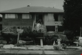
![Boy with a push mower, [between 1930 and 1935] thumbnail](/media/hpo/_Data/_BVM_Images/1985/198557920001.jpg?width=280)
Boy with a push mower
https://search.heritageburnaby.ca/link/museumdescription1418
- Repository
- Burnaby Village Museum
- Date
- [between 1930 and 1935]
- Collection/Fonds
- Burnaby Village Museum Photograph collection
- Description Level
- Item
- Physical Description
- 1 photograph : b&w
- Scope and Content
- Photograph of an unidentified young boy (toddler aged) in a striped shirt and a cloth diaper, standing beside a push mower. There are two houses in the background with two children standing on the sidewalk. The location is not identified.
- Repository
- Burnaby Village Museum
- Collection/Fonds
- Burnaby Village Museum Photograph collection
- Description Level
- Item
- Physical Description
- 1 photograph : b&w
- Material Details
- The name "velox" is lightly printed on the back of the photo paper: thus, the photograph is printed on Kodak velox photo paper made in early 1900s for amateur photography.
- stamped on verso, l.r. [upside down] "139"
- Scope and Content
- Photograph of an unidentified young boy (toddler aged) in a striped shirt and a cloth diaper, standing beside a push mower. There are two houses in the background with two children standing on the sidewalk. The location is not identified.
- Accession Code
- BV985.5792.1
- Access Restriction
- No restrictions
- Reproduction Restriction
- No known restrictions
- Date
- [between 1930 and 1935]
- Media Type
- Photograph
- Scan Resolution
- 600
- Scan Date
- 2024-02-02
- Notes
- Title based on contents of photograph
Images
![Boy with a push mower, [between 1930 and 1935] thumbnail](/media/hpo/_Data/_BVM_Images/1985/198557920001.jpg)
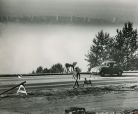
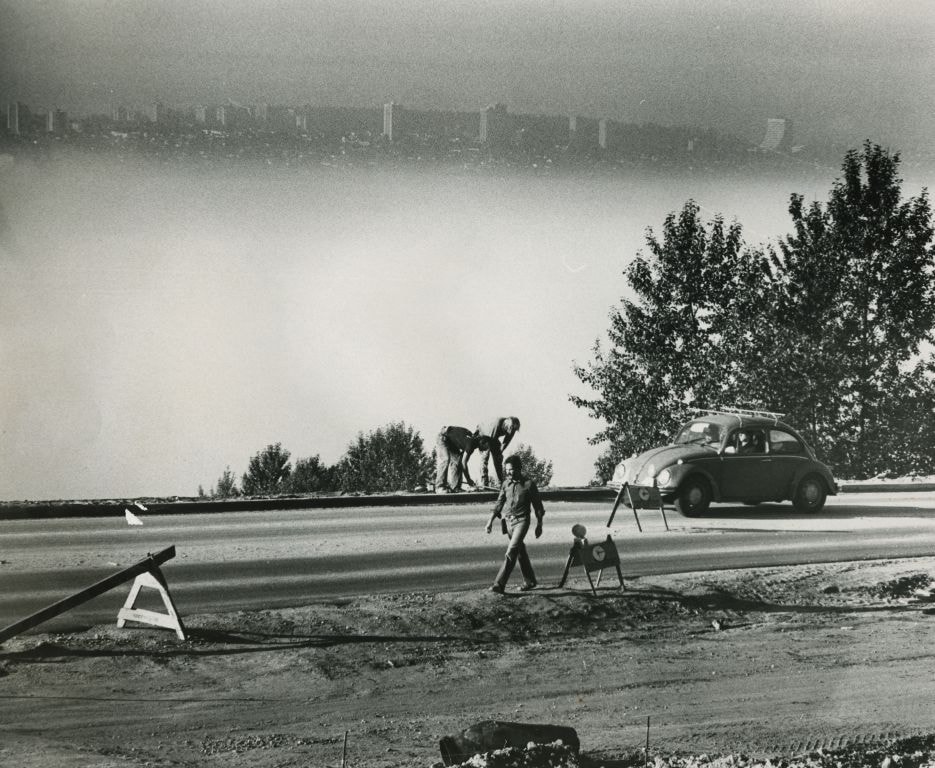
Road work in progess - View of the city in the background
https://search.heritageburnaby.ca/link/archivedescription59140
- Repository
- City of Burnaby Archives
- Date
- ca.1983
- Collection/Fonds
- Columbian Newspaper collection
- Description Level
- Item
- Physical Description
- 1 photograph : b&w ; 20.5 x 25.5 cm
- Scope and Content
- Photograph of a road under construction and labourers.
- Repository
- City of Burnaby Archives
- Date
- ca.1983
- Collection/Fonds
- Columbian Newspaper collection
- Physical Description
- 1 photograph : b&w ; 20.5 x 25.5 cm
- Description Level
- Item
- Record No.
- 480-1478
- Access Restriction
- No restrictions
- Reproduction Restriction
- Reproduce for fair dealing purposes only
- Accession Number
- 2009-01
- Scope and Content
- Photograph of a road under construction and labourers.
- Media Type
- Photograph
- Photographer
- King, Basil
- Notes
- Title based on contents of photograph
- Photographer's stamp on verso
- Note on verso reads: "Page A-4 / Burnaby / Today / PMT 100%"
Images