Narrow Results By
Decade
- 2020s
- 2010s
- 2000s 1824
- 1990s
- 1980s
- 1970s 3517
- 1960s 1358
- 1950s 1712
- 1940s 2148
- 1930s 2158
- 1920s 2489
- 1910s 2036
- 1900s 870
- 1890s 250
- 1880s 165
- 1870s 72
- 1860s 123
- 1850s 14
- 1840s 5
- 1830s 3
- 1820s 2
- 1810s 3
- 1800s 3
- 1790s 2
- 1780s 2
- 1770s 2
- 1760s 2
- 1750s 2
- 1740s 2
- 1730s 2
- 1720s 2
- 1710s 2
- 1700s 2
- 1690s 2
- 1680s 2
- 1670s 1
- 1660s 1
- 1650s 1
- 1640s 1
- 1630s 1
- 1620s 1
- 1610s 1
- 1600s
- 1590s 1
- 1580s 1
- 1570s 1
- 1560s 1
- 1550s 1
- 1540s 1
- 1530s 1
- 1520s 2
- 1510s 1
- 1500s 1
- 1490s 1
- 1480s 1
Subject
- Accidents 3
- Accidents - Automobile Accidents 14
- Advertising Medium 1
- Advertising Medium - Poster 1
- Advertising Medium - Signs and Signboards 66
- Aerial Photographs 2
- Agricultural Tools and Equipment - Gardening Equipment 1
- Agriculture 8
- Agriculture - Crops 2
- Agriculture - Farms 17
- Agriculture - Fruit and Berries 1
- Agriculture - Ranches 1
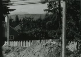
![4674 Southlawn Drive, [1989 or 1990] (date of original), copied 1991 thumbnail](/media/hpo/_Data/_Archives_Images/_Unrestricted/370/370-463.jpg?width=280)
4674 Southlawn Drive
https://search.heritageburnaby.ca/link/archivedescription37875
- Repository
- City of Burnaby Archives
- Date
- [1989 or 1990] (date of original), copied 1991
- Collection/Fonds
- Burnaby Historical Society fonds
- Description Level
- Item
- Physical Description
- 1 photograph : b&w ; 3.7 x 4.7 cm print on contact sheet 20.1 x 26.7 cm
- Scope and Content
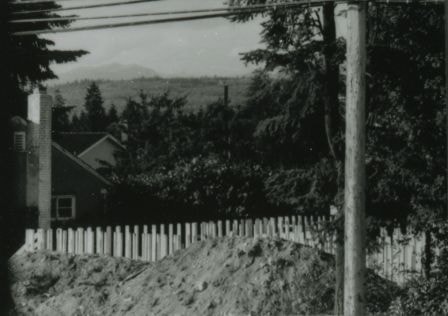
- Photograph taken from 4674 Southlawn Drive after a snowfall, facing northwest.
- Repository
- City of Burnaby Archives
- Date
- [1989 or 1990] (date of original), copied 1991
- Collection/Fonds
- Burnaby Historical Society fonds
- Subseries
- Burnaby Image Bank subseries
- Physical Description
- 1 photograph : b&w ; 3.7 x 4.7 cm print on contact sheet 20.1 x 26.7 cm
- Description Level
- Item
- Record No.
- 370-463
- Access Restriction
- No restrictions
- Reproduction Restriction
- No restrictions
- Accession Number
- BHS1999-03
- Scope and Content
- Photograph taken from 4674 Southlawn Drive after a snowfall, facing northwest.
- Media Type
- Photograph
- Notes
- Title based on contents of photograph
- 1 b&w copy negative accompanying
- Negative has a pink cast
- Copied from col. photograph
- Geographic Access
- Southlawn Drive
- Planning Study Area
- Brentwood Area
Images
![4674 Southlawn Drive, [1989 or 1990] (date of original), copied 1991 thumbnail](/media/hpo/_Data/_Archives_Images/_Unrestricted/370/370-463.jpg)

5130 Irving Street
https://search.heritageburnaby.ca/link/archivedescription98671
- Repository
- City of Burnaby Archives
- Date
- 2022
- Collection/Fonds
- Disappearing Burnaby collection
- Description Level
- Item
- Physical Description
- 1 photograph (jpeg) : col.
- Scope and Content
- Photograph of the front steps and the entrance of a three-storey apartment building located at 5130 Irving Street. The photograph depicts the building at night, with the lobby and some of the apartments' windows illuminated from inside. The building was constructed in 1971.
- Repository
- City of Burnaby Archives
- Date
- 2022
- Collection/Fonds
- Disappearing Burnaby collection
- Physical Description
- 1 photograph (jpeg) : col.
- Description Level
- Item
- Record No.
- 634-018
- Access Restriction
- No restrictions
- Reproduction Restriction
- No restrictions
- Accession Number
- 2022-14
- Scope and Content
- Photograph of the front steps and the entrance of a three-storey apartment building located at 5130 Irving Street. The photograph depicts the building at night, with the lobby and some of the apartments' windows illuminated from inside. The building was constructed in 1971.
- Media Type
- Photograph
- Photographer
- Cheung, Nakita
- Notes
- Title taken from the associated blog post
- Associated blog post: https://disappearingburnaby.wordpress.com/2022/05/04/e-just-e/
- Geographic Access
- Irving Street
- Street Address
- 5130 Irving Street
- Historic Neighbourhood
- Central Park (Historic Neighbourhood)
- Planning Study Area
- Marlborough Area
Images


5130 Irving Street lobby
https://search.heritageburnaby.ca/link/archivedescription98672
- Repository
- City of Burnaby Archives
- Date
- 2022
- Collection/Fonds
- Disappearing Burnaby collection
- Description Level
- Item
- Physical Description
- 1 photograph (jpeg) : col.
- Scope and Content
- Photograph of the entrance of an apartment building located at 5130 Irving Street. The building was constructed in 1971. The photograph depicts the entrance and the lobby from the exterior at night. The lobby is illuminated and a crest featuring an "E" is on the entrance window.
- Repository
- City of Burnaby Archives
- Date
- 2022
- Collection/Fonds
- Disappearing Burnaby collection
- Physical Description
- 1 photograph (jpeg) : col.
- Description Level
- Item
- Record No.
- 634-019
- Access Restriction
- No restrictions
- Reproduction Restriction
- No restrictions
- Accession Number
- 2022-14
- Scope and Content
- Photograph of the entrance of an apartment building located at 5130 Irving Street. The building was constructed in 1971. The photograph depicts the entrance and the lobby from the exterior at night. The lobby is illuminated and a crest featuring an "E" is on the entrance window.
- Media Type
- Photograph
- Photographer
- Cheung, Nakita
- Notes
- Title taken from the associated blog post
- Associated blog post: https://disappearingburnaby.wordpress.com/2022/05/04/e-just-e/
- Geographic Access
- Irving Street
- Street Address
- 5130 Irving Street
- Historic Neighbourhood
- Central Park (Historic Neighbourhood)
- Planning Study Area
- Marlborough Area
Images


5486 Dominion Street
https://search.heritageburnaby.ca/link/archivedescription91872
- Repository
- City of Burnaby Archives
- Date
- May 1994
- Collection/Fonds
- Small family fonds
- Description Level
- Item
- Physical Description
- 1 photograph : b&w ; 10 cm x 15 cm
- Scope and Content
- Photograph of a two-storey house at 5486 Dominion Street. The Dehn family purchased the house on this property in 1971 or 1972 and raised it several years later to build a complete furnished basement underneath it. This photograph was taken just prior to the demolition of the house following its …
- Repository
- City of Burnaby Archives
- Date
- May 1994
- Collection/Fonds
- Small family fonds
- Physical Description
- 1 photograph : b&w ; 10 cm x 15 cm
- Description Level
- Item
- Record No.
- 620-053
- Access Restriction
- No restrictions
- Reproduction Restriction
- No reproduction permitted
- Accession Number
- 2017-01
- Scope and Content
- Photograph of a two-storey house at 5486 Dominion Street. The Dehn family purchased the house on this property in 1971 or 1972 and raised it several years later to build a complete furnished basement underneath it. This photograph was taken just prior to the demolition of the house following its sale and the subdivision of the property into two 33 foot lots.
- Subjects
- Buildings - Residential - Houses
- Media Type
- Photograph
- Notes
- Transcribed title
- Title transcribed from donor's notes
- Note in blue ink on verso of photograph reads: "P.15"
- Note in blue ink on verso of photograph reads: "5486 Dominion St / Just before demolition - May 1994"
- 5486 Dominion Street subdivided into two lots: 5480 and 5488 Dominion Street
- Street Address
- 5486 Dominion Street
- Historic Neighbourhood
- Burnaby Lake (Historic Neighbourhood)
- Planning Study Area
- Ardingley-Sprott Area
Images


5495 Dominion Street and 5505 Dominion Street
https://search.heritageburnaby.ca/link/archivedescription91857
- Repository
- City of Burnaby Archives
- Date
- April 1, 2015
- Collection/Fonds
- Small family fonds
- Description Level
- Item
- Physical Description
- 1 photograph : col. ; 10 cm x 15 cm
- Scope and Content
- Photograph of a tan duplex located at 5495 Dominion Street (left) and clay-coloured house at 5505 Dominion Street (right). The photograph was taken from 5496 Dominion street, looking north.
- Repository
- City of Burnaby Archives
- Date
- April 1, 2015
- Collection/Fonds
- Small family fonds
- Physical Description
- 1 photograph : col. ; 10 cm x 15 cm
- Description Level
- Item
- Record No.
- 620-038
- Access Restriction
- No restrictions
- Reproduction Restriction
- No reproduction permitted
- Accession Number
- 2017-01
- Scope and Content
- Photograph of a tan duplex located at 5495 Dominion Street (left) and clay-coloured house at 5505 Dominion Street (right). The photograph was taken from 5496 Dominion street, looking north.
- Subjects
- Buildings - Residential - Houses
- Media Type
- Photograph
- Notes
- Transcribed title
- Title transcribed from donor's notes
- Note in blue ink on verso of photograph reads: "P.37"
- Note in blue ink on verso of photograph reads: "April 1 , 2015 / 5495 Dominion st. 5505 Dominion St."
- 5493 Dominion Street was previously numbered 3107 Dominion Street and it was later subdivided into two lots: 5491 and 5495 Dominion Street.
- Photograph 620-037 depicts the same houses prior to being repainted.
- Historic Neighbourhood
- Burnaby Lake (Historic Neighbourhood)
- Planning Study Area
- Ardingley-Sprott Area
Images


5990 Irmin Street
https://search.heritageburnaby.ca/link/archivedescription98685
- Repository
- City of Burnaby Archives
- Date
- 2022
- Collection/Fonds
- Disappearing Burnaby collection
- Description Level
- Item
- Physical Description
- 1 photograph (jpeg) : col.
- Scope and Content
- Photograph of a multi-storey house located at 5990 Irmin Street. The photograph depicts of the exterior of the house at dusk; a light is on in one of the house's rooms and a vehicle is parked in the house's driveway next to a portable garage. A "For Sale" sign on the edge of the property reads: "Fu…
- Repository
- City of Burnaby Archives
- Date
- 2022
- Collection/Fonds
- Disappearing Burnaby collection
- Physical Description
- 1 photograph (jpeg) : col.
- Description Level
- Item
- Record No.
- 634-032
- Access Restriction
- No restrictions
- Reproduction Restriction
- No restrictions
- Accession Number
- 2022-14
- Scope and Content
- Photograph of a multi-storey house located at 5990 Irmin Street. The photograph depicts of the exterior of the house at dusk; a light is on in one of the house's rooms and a vehicle is parked in the house's driveway next to a portable garage. A "For Sale" sign on the edge of the property reads: "Future Development Land." Another house is visible in the background. The house was constructed in 1923 and is nearby to 7530 Buller Avenue.
- Media Type
- Photograph
- Photographer
- Cheung, Nakita
- Notes
- Title taken from the associated blog post
- Associated blog post: https://disappearingburnaby.wordpress.com/2022/06/30/william-esther-burdick-residence/
- Geographic Access
- Irmin Street
- Street Address
- 5990 Irmin Street
- Historic Neighbourhood
- Alta Vista (Historic Neighbourhood)
- Planning Study Area
- Clinton-Glenwood Area
Images


6113 Silver Avenue lot
https://search.heritageburnaby.ca/link/archivedescription37775
- Repository
- City of Burnaby Archives
- Date
- 1986 (date of original), copied 1991
- Collection/Fonds
- Burnaby Historical Society fonds
- Description Level
- Item
- Physical Description
- 1 photograph : b&w ; 3.1 x 4.4 cm print on contact sheet 20.3 x 26.2 cm
- Scope and Content
- Photograph of the lot at 6113 Silver Avenue, the former home of the Ellis family. The house has been demolished and an empty lot remains. Houses, aparment buildings, and the Expo line skytrain track with cars on it can be seen in the background.
- Repository
- City of Burnaby Archives
- Date
- 1986 (date of original), copied 1991
- Collection/Fonds
- Burnaby Historical Society fonds
- Subseries
- Burnaby Image Bank subseries
- Physical Description
- 1 photograph : b&w ; 3.1 x 4.4 cm print on contact sheet 20.3 x 26.2 cm
- Description Level
- Item
- Record No.
- 370-363
- Access Restriction
- No restrictions
- Reproduction Restriction
- No restrictions
- Accession Number
- BHS1999-03
- Scope and Content
- Photograph of the lot at 6113 Silver Avenue, the former home of the Ellis family. The house has been demolished and an empty lot remains. Houses, aparment buildings, and the Expo line skytrain track with cars on it can be seen in the background.
- Subjects
- Land Clearing
- Media Type
- Photograph
- Notes
- Title based on contents of photograph
- 1 b&w copy negative accompanying
- Negative has a pink cast
- Copied from col. photograph
- Geographic Access
- Silver Avenue
- Street Address
- 6113 Silver Avenue
- Historic Neighbourhood
- Central Park (Historic Neighbourhood)
- Planning Study Area
- Maywood Area
Images


6280 Marlborough Avenue
https://search.heritageburnaby.ca/link/archivedescription98673
- Repository
- City of Burnaby Archives
- Date
- 2022
- Collection/Fonds
- Disappearing Burnaby collection
- Description Level
- Item
- Physical Description
- 1 photograph (jpeg) : col.
- Scope and Content
- Photograph of the front steps and entry to a three-storey apartment building, located at 6280 Marlborough Avenue. The photograph depicts the building at night and shows the brick building's details, including its lion statues and busts along the stair railings and the curved arches in front of the …
- Repository
- City of Burnaby Archives
- Date
- 2022
- Collection/Fonds
- Disappearing Burnaby collection
- Physical Description
- 1 photograph (jpeg) : col.
- Description Level
- Item
- Record No.
- 634-020
- Access Restriction
- No restrictions
- Reproduction Restriction
- No restrictions
- Accession Number
- 2022-14
- Scope and Content
- Photograph of the front steps and entry to a three-storey apartment building, located at 6280 Marlborough Avenue. The photograph depicts the building at night and shows the brick building's details, including its lion statues and busts along the stair railings and the curved arches in front of the front windows and door. The building was constructed in 1973.
- Media Type
- Photograph
- Photographer
- Cheung, Nakita
- Notes
- Title taken from the associated blog post
- Associated blog post: https://disappearingburnaby.wordpress.com/2022/05/12/marlborough-ave/
- Geographic Access
- Marlborough Avenue
- Street Address
- 6280 Marlborough Avenue
- Historic Neighbourhood
- Central Park (Historic Neighbourhood)
- Planning Study Area
- Marlborough Area
Images


6410 Denbigh Avenue
https://search.heritageburnaby.ca/link/archivedescription98667
- Repository
- City of Burnaby Archives
- Date
- 2022
- Collection/Fonds
- Disappearing Burnaby collection
- Description Level
- Item
- Physical Description
- 1 photograph (jpeg) : col.
- Scope and Content
- Photograph of the exterior of a single-storey house located at 6410 Denbigh Avenue, taken from across the street at dusk. The house was constructed in 1949. Lights illuminate the front porch and the interior of one of the house's windows and there is a small amount of snow on the lawn in front of t…
- Repository
- City of Burnaby Archives
- Date
- 2022
- Collection/Fonds
- Disappearing Burnaby collection
- Physical Description
- 1 photograph (jpeg) : col.
- Description Level
- Item
- Record No.
- 634-014
- Access Restriction
- No restrictions
- Reproduction Restriction
- No restrictions
- Accession Number
- 2022-14
- Scope and Content
- Photograph of the exterior of a single-storey house located at 6410 Denbigh Avenue, taken from across the street at dusk. The house was constructed in 1949. Lights illuminate the front porch and the interior of one of the house's windows and there is a small amount of snow on the lawn in front of the house.
- Media Type
- Photograph
- Photographer
- Cheung, Nakita
- Notes
- Title taken from the associated blog post
- Associated blog post: https://disappearingburnaby.wordpress.com/2022/05/15/denbigh-ave/
- Geographic Access
- Denbigh Avenue
- Street Address
- 6410 Denbigh Avenue
- Historic Neighbourhood
- Central Park (Historic Neighbourhood)
- Planning Study Area
- Windsor Area
Images


6508 Silver Avenue
https://search.heritageburnaby.ca/link/archivedescription98678
- Repository
- City of Burnaby Archives
- Date
- 2022
- Collection/Fonds
- Disappearing Burnaby collection
- Description Level
- Item
- Physical Description
- 1 photograph (jpeg) : col.
- Scope and Content
- Photograph of the corner and side of the exterior of a concrete low-rise apartment building located at 6508 Silver Avenue. The photograph depicts the building at dusk. Some of the apartment windows are lit up from inside, and plant pots are lined up along the third-floor balcony. A chain link fence…
- Repository
- City of Burnaby Archives
- Date
- 2022
- Collection/Fonds
- Disappearing Burnaby collection
- Physical Description
- 1 photograph (jpeg) : col.
- Description Level
- Item
- Record No.
- 634-025
- Access Restriction
- No restrictions
- Reproduction Restriction
- No restrictions
- Accession Number
- 2022-14
- Scope and Content
- Photograph of the corner and side of the exterior of a concrete low-rise apartment building located at 6508 Silver Avenue. The photograph depicts the building at dusk. Some of the apartment windows are lit up from inside, and plant pots are lined up along the third-floor balcony. A chain link fence surrounds the backyard. The building was constructed in 1966.
- Media Type
- Photograph
- Photographer
- Cheung, Nakita
- Notes
- Title taken from the associated blog post
- Associated blog post: https://disappearingburnaby.wordpress.com/2022/06/30/brutalist/
- Geographic Access
- Silver Avenue
- Street Address
- 6508 Silver Avenue
- Historic Neighbourhood
- Central Park (Historic Neighbourhood)
- Planning Study Area
- Maywood Area
Images


6615 Telford Avenue
https://search.heritageburnaby.ca/link/archivedescription98674
- Repository
- City of Burnaby Archives
- Date
- 2022
- Collection/Fonds
- Disappearing Burnaby collection
- Description Level
- Item
- Physical Description
- 1 photograph (jpeg) : col.
- Scope and Content
- Photograph of the entrance, including the front steps and ramp, to a low-rise apartment building located at 6615 Telford Avenue. The building was constructed in 1964. The photograph depicts the building at night, and trees and bushes partially obscure the entrance. The building's lobby is illuminat…
- Repository
- City of Burnaby Archives
- Date
- 2022
- Collection/Fonds
- Disappearing Burnaby collection
- Physical Description
- 1 photograph (jpeg) : col.
- Description Level
- Item
- Record No.
- 634-021
- Access Restriction
- No restrictions
- Reproduction Restriction
- No restrictions
- Accession Number
- 2022-14
- Scope and Content
- Photograph of the entrance, including the front steps and ramp, to a low-rise apartment building located at 6615 Telford Avenue. The building was constructed in 1964. The photograph depicts the building at night, and trees and bushes partially obscure the entrance. The building's lobby is illuminated and the apartments' mailboxes are visible through the window.
- Media Type
- Photograph
- Photographer
- Cheung, Nakita
- Notes
- Title taken from the associated blog post
- Associated blog post: https://disappearingburnaby.wordpress.com/2022/06/09/martello-group/
- Geographic Access
- Telford Avenue
- Street Address
- 6615 Telford Avenue
- Historic Neighbourhood
- Central Park (Historic Neighbourhood)
- Planning Study Area
- Maywood Area
Images


6692 Dow Avenue
https://search.heritageburnaby.ca/link/archivedescription98662
- Repository
- City of Burnaby Archives
- Date
- 2022
- Collection/Fonds
- Disappearing Burnaby collection
- Description Level
- Item
- Physical Description
- 1 photograph (jpeg) : col.
- Scope and Content
- Photograph of the exterior of a two-storey apartment building located at 6692 Dow Avenue. The photograph depicts the building from across the street at night; the lobby and some of the apartment windows are lit up, with a bunch of balloons in one window, and a car is parked on the street in front o…
- Repository
- City of Burnaby Archives
- Date
- 2022
- Collection/Fonds
- Disappearing Burnaby collection
- Physical Description
- 1 photograph (jpeg) : col.
- Description Level
- Item
- Record No.
- 634-009
- Access Restriction
- No restrictions
- Reproduction Restriction
- No restrictions
- Accession Number
- 2022-14
- Scope and Content
- Photograph of the exterior of a two-storey apartment building located at 6692 Dow Avenue. The photograph depicts the building from across the street at night; the lobby and some of the apartment windows are lit up, with a bunch of balloons in one window, and a car is parked on the street in front of the building. The building was constructed in 1959.
- Media Type
- Photograph
- Photographer
- Cheung, Nakita
- Notes
- Title taken from the associated blog post
- Associated blog post: https://disappearingburnaby.wordpress.com/2022/03/01/dow-ave/
- Geographic Access
- Dow Avenue
- Street Address
- 6692 Dow Avenue
- Historic Neighbourhood
- Central Park (Historic Neighbourhood)
- Planning Study Area
- Maywood Area
Images


6700 Dow Avenue
https://search.heritageburnaby.ca/link/archivedescription98663
- Repository
- City of Burnaby Archives
- Date
- 2022
- Collection/Fonds
- Disappearing Burnaby collection
- Description Level
- Item
- Physical Description
- 1 photograph (jpeg) : col.
- Scope and Content
- Photograph of the entrance to an apartment building located at 6700 Dow Avenue. The photograph depicts the building at night; the lobby and stairs are illuminated by exterior and interior lights. The building was constructed in 1968.
- Repository
- City of Burnaby Archives
- Date
- 2022
- Collection/Fonds
- Disappearing Burnaby collection
- Physical Description
- 1 photograph (jpeg) : col.
- Description Level
- Item
- Record No.
- 634-010
- Access Restriction
- No restrictions
- Reproduction Restriction
- No restrictions
- Accession Number
- 2022-14
- Scope and Content
- Photograph of the entrance to an apartment building located at 6700 Dow Avenue. The photograph depicts the building at night; the lobby and stairs are illuminated by exterior and interior lights. The building was constructed in 1968.
- Media Type
- Photograph
- Photographer
- Cheung, Nakita
- Notes
- Title taken from the associated blog post
- Associated blog post: https://disappearingburnaby.wordpress.com/2022/03/29/no-pes/
- Geographic Access
- Dow Avenue
- Street Address
- 6700 Dow Avenue
- Historic Neighbourhood
- Central Park (Historic Neighbourhood)
- Planning Study Area
- Maywood Area
Images


6742 Walker Avenue
https://search.heritageburnaby.ca/link/archivedescription37844
- Repository
- City of Burnaby Archives
- Date
- May 1987 (date of original), copied 1991
- Collection/Fonds
- Burnaby Historical Society fonds
- Description Level
- Item
- Physical Description
- 1 photograph : b&w ; 3.1 x 4.3 cm print on contact sheet 20.6 x 26.7 cm
- Scope and Content
- Photograph of 6742 Walker Avenue, with only the trees in the yard visible from the road. A van is parked in front.
- Repository
- City of Burnaby Archives
- Date
- May 1987 (date of original), copied 1991
- Collection/Fonds
- Burnaby Historical Society fonds
- Subseries
- Burnaby Image Bank subseries
- Physical Description
- 1 photograph : b&w ; 3.1 x 4.3 cm print on contact sheet 20.6 x 26.7 cm
- Description Level
- Item
- Record No.
- 370-432
- Access Restriction
- No restrictions
- Reproduction Restriction
- No restrictions
- Accession Number
- BHS1999-03
- Scope and Content
- Photograph of 6742 Walker Avenue, with only the trees in the yard visible from the road. A van is parked in front.
- Subjects
- Plants - Trees
- Media Type
- Photograph
- Notes
- Title based on contents of photograph
- 1 b&w copy negative accompanying
- Negative has a pink cast
- Copied from col. photograph
- Geographic Access
- Walker Avenue
- Street Address
- 6742 Walker Avenue
- Historic Neighbourhood
- Edmonds (Historic Neighbourhood)
- Planning Study Area
- Richmond Park Area
Images


6742 Walker Avenue
https://search.heritageburnaby.ca/link/archivedescription37845
- Repository
- City of Burnaby Archives
- Date
- May 1987 (date of original), copied 1991
- Collection/Fonds
- Burnaby Historical Society fonds
- Description Level
- Item
- Physical Description
- 1 photograph : b&w ; 3.0 x 4.4 cm print on contact sheet 20.6 x 26.7 cm
- Scope and Content
- Photograph of 6742 Walker Avenue with some of the trees in the yard cut down.
- Repository
- City of Burnaby Archives
- Date
- May 1987 (date of original), copied 1991
- Collection/Fonds
- Burnaby Historical Society fonds
- Subseries
- Burnaby Image Bank subseries
- Physical Description
- 1 photograph : b&w ; 3.0 x 4.4 cm print on contact sheet 20.6 x 26.7 cm
- Description Level
- Item
- Record No.
- 370-433
- Access Restriction
- No restrictions
- Reproduction Restriction
- No restrictions
- Accession Number
- BHS1999-03
- Scope and Content
- Photograph of 6742 Walker Avenue with some of the trees in the yard cut down.
- Subjects
- Plants - Trees
- Media Type
- Photograph
- Notes
- Title based on contents of photograph
- 1 b&w copy negative accompanying
- Negative has a pink cast
- Copied from col. photograph
- Geographic Access
- Walker Avenue
- Street Address
- 6742 Walker Avenue
- Historic Neighbourhood
- Edmonds (Historic Neighbourhood)
- Planning Study Area
- Richmond Park Area
Images


6742 Walker Avenue
https://search.heritageburnaby.ca/link/archivedescription37846
- Repository
- City of Burnaby Archives
- Date
- May 1987 (date of original), copied 1991
- Collection/Fonds
- Burnaby Historical Society fonds
- Description Level
- Item
- Physical Description
- 1 photograph : b&w ; 3.0 x 4.3 cm print on contact sheet 20.6 x 26.7 cm
- Scope and Content
- Photograph of 6742 Walker Avenue, showing the stumps of the recently cut down trees in the yard of the house.
- Repository
- City of Burnaby Archives
- Date
- May 1987 (date of original), copied 1991
- Collection/Fonds
- Burnaby Historical Society fonds
- Subseries
- Burnaby Image Bank subseries
- Physical Description
- 1 photograph : b&w ; 3.0 x 4.3 cm print on contact sheet 20.6 x 26.7 cm
- Description Level
- Item
- Record No.
- 370-434
- Access Restriction
- No restrictions
- Reproduction Restriction
- No restrictions
- Accession Number
- BHS1999-03
- Scope and Content
- Photograph of 6742 Walker Avenue, showing the stumps of the recently cut down trees in the yard of the house.
- Media Type
- Photograph
- Notes
- Title based on contents of photograph
- 1 b&w copy negative accompanying
- Negative has a pink cast
- Copied from col. photograph
- Geographic Access
- Walker Avenue
- Street Address
- 6742 Walker Avenue
- Historic Neighbourhood
- Edmonds (Historic Neighbourhood)
- Planning Study Area
- Richmond Park Area
Images

6742 Walker Avenue
https://search.heritageburnaby.ca/link/archivedescription37853
- Repository
- City of Burnaby Archives
- Date
- June 1987 (date of original), copied 1991
- Collection/Fonds
- Burnaby Historical Society fonds
- Description Level
- Item
- Physical Description
- 1 photograph : b&w ; 3.0 x 4.3 cm print on contact sheet 20.6 x 26.7 cm
- Scope and Content
- Photograph of the foundation of a house at 6742 Walker Avenue.
- Repository
- City of Burnaby Archives
- Date
- June 1987 (date of original), copied 1991
- Collection/Fonds
- Burnaby Historical Society fonds
- Subseries
- Burnaby Image Bank subseries
- Physical Description
- 1 photograph : b&w ; 3.0 x 4.3 cm print on contact sheet 20.6 x 26.7 cm
- Description Level
- Item
- Record No.
- 370-441
- Access Restriction
- No restrictions
- Reproduction Restriction
- No restrictions
- Accession Number
- BHS1999-03
- Scope and Content
- Photograph of the foundation of a house at 6742 Walker Avenue.
- Media Type
- Photograph
- Notes
- Title based on contents of photograph
- 1 b&w copy negative accompanying
- Negative has a pink cast
- Copied from col. photograph
- Geographic Access
- Walker Avenue
- Street Address
- 6742 Walker Avenue
- Historic Neighbourhood
- Edmonds (Historic Neighbourhood)
- Planning Study Area
- Richmond Park Area
Images
6742 Walker Avenue
https://search.heritageburnaby.ca/link/archivedescription37863
- Repository
- City of Burnaby Archives
- Date
- 1987 (date of original), copied 1991
- Collection/Fonds
- Burnaby Historical Society fonds
- Description Level
- Item
- Physical Description
- 1 photograph : b&w ; 3.1 x 4.6 cm print on contact sheet 20.4 x 26.7 cm
- Scope and Content
- Photograph of the completed construction of a house at 6742 Walker Avenue, summer 1987.
- Repository
- City of Burnaby Archives
- Date
- 1987 (date of original), copied 1991
- Collection/Fonds
- Burnaby Historical Society fonds
- Subseries
- Burnaby Image Bank subseries
- Physical Description
- 1 photograph : b&w ; 3.1 x 4.6 cm print on contact sheet 20.4 x 26.7 cm
- Description Level
- Item
- Record No.
- 370-451
- Access Restriction
- No restrictions
- Reproduction Restriction
- No restrictions
- Accession Number
- BHS1999-03
- Scope and Content
- Photograph of the completed construction of a house at 6742 Walker Avenue, summer 1987.
- Subjects
- Buildings - Residential - Houses
- Media Type
- Photograph
- Notes
- Title based on contents of photograph
- 1 b&w copy negative accompanying
- Negative has a pink cast
- Copied from col. photograph
- Geographic Access
- Walker Avenue
- Street Address
- 6742 Walker Avenue
- Historic Neighbourhood
- Edmonds (Historic Neighbourhood)
- Planning Study Area
- Richmond Park Area
Images


6742 Walker Avenue
https://search.heritageburnaby.ca/link/archivedescription37864
- Repository
- City of Burnaby Archives
- Date
- 1990 (date of original), copied 1991
- Collection/Fonds
- Burnaby Historical Society fonds
- Description Level
- Item
- Physical Description
- 1 photograph : b&w ; 3.2 x 4.8 cm print on contact sheet 20.4 x 26.7 cm
- Scope and Content
- Photograph of 6742 Walker Avenue, taken in the summer of 1990.
- Repository
- City of Burnaby Archives
- Date
- 1990 (date of original), copied 1991
- Collection/Fonds
- Burnaby Historical Society fonds
- Subseries
- Burnaby Image Bank subseries
- Physical Description
- 1 photograph : b&w ; 3.2 x 4.8 cm print on contact sheet 20.4 x 26.7 cm
- Description Level
- Item
- Record No.
- 370-452
- Access Restriction
- No restrictions
- Reproduction Restriction
- No restrictions
- Accession Number
- BHS1999-03
- Scope and Content
- Photograph of 6742 Walker Avenue, taken in the summer of 1990.
- Subjects
- Buildings - Residential - Houses
- Media Type
- Photograph
- Notes
- Title based on contents of photograph
- 1 b&w copy negative accompanying
- Negative has a pink cast
- Copied from col. photograph
- Geographic Access
- Walker Avenue
- Street Address
- 6742 Walker Avenue
- Historic Neighbourhood
- East Burnaby (Historic Neighbourhood)
- Planning Study Area
- Richmond Park Area
Images

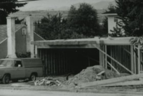
6742 Walker Avenue construction
https://search.heritageburnaby.ca/link/archivedescription37854
- Repository
- City of Burnaby Archives
- Date
- June 1987 (date of original), copied 1991
- Collection/Fonds
- Burnaby Historical Society fonds
- Description Level
- Item
- Physical Description
- 1 photograph : b&w ; 3.0 x 4.3 cm print on contact sheet 20.6 x 26.7 cm
- Scope and Content
- Photograph of the garage and ground floor frame of a house at 6742 Walker Avenue, mid to late June, 1987. A truck is parked in front.
- Repository
- City of Burnaby Archives
- Date
- June 1987 (date of original), copied 1991
- Collection/Fonds
- Burnaby Historical Society fonds
- Subseries
- Burnaby Image Bank subseries
- Physical Description
- 1 photograph : b&w ; 3.0 x 4.3 cm print on contact sheet 20.6 x 26.7 cm
- Description Level
- Item
- Record No.
- 370-442
- Access Restriction
- No restrictions
- Reproduction Restriction
- No restrictions
- Accession Number
- BHS1999-03
- Scope and Content
- Photograph of the garage and ground floor frame of a house at 6742 Walker Avenue, mid to late June, 1987. A truck is parked in front.
- Subjects
- Construction
- Media Type
- Photograph
- Notes
- Title based on contents of photograph
- 1 b&w copy negative accompanying
- Negative has a pink cast
- Copied from col. photograph
- Geographic Access
- Walker Avenue
- Street Address
- 6742 Walker Avenue
- Historic Neighbourhood
- Edmonds (Historic Neighbourhood)
- Planning Study Area
- Richmond Park Area
Images
