Narrow Results By
Subject
- Accidents - Train Accidents 1
- Advertising Medium - Signs and Signboards
- Aerial Photographs 1
- Agricultural Tools and Equipment 2
- Agricultural Tools and Equipment - Plows 1
- Agriculture - Crops 7
- Agriculture - Farms
- Agriculture - Fruit and Berries 9
- Agriculture - Orchards 1
- Agriculture - Poultry 3
- Animals - Cats 7
- Animals - Cows 8
![Keel farm house, [192-] thumbnail](/media/hpo/_Data/_Archives_Images/_Unrestricted/251/279-001.jpg?width=280)
Keel farm house
https://search.heritageburnaby.ca/link/archivedescription36488
- Repository
- City of Burnaby Archives
- Date
- [192-]
- Collection/Fonds
- Burnaby Historical Society fonds
- Description Level
- Item
- Physical Description
- 1 photograph : b&w ; 8.5 x 12.5 cm print
- Scope and Content
- Photograph of the A.J. Keel farm house and orchard, at 5387 Rumble Street. A.J. Keel bought this property, which went from Rumble to Walting, in 1920.
- Repository
- City of Burnaby Archives
- Date
- [192-]
- Collection/Fonds
- Burnaby Historical Society fonds
- Subseries
- Keel family subseries
- Physical Description
- 1 photograph : b&w ; 8.5 x 12.5 cm print
- Description Level
- Item
- Record No.
- 279-001
- Access Restriction
- No restrictions
- Reproduction Restriction
- No known restrictions
- Accession Number
- BHS1992-09
- Scope and Content
- Photograph of the A.J. Keel farm house and orchard, at 5387 Rumble Street. A.J. Keel bought this property, which went from Rumble to Walting, in 1920.
- Media Type
- Photograph
- Notes
- Title based on contents of photograph
- Geographic Access
- Rumble Street
- Street Address
- 5387 Rumble Street
- Historic Neighbourhood
- Alta-Vista (Historic Neighbourhood)
- Planning Study Area
- Clinton-Glenwood Area
Images
![Keel farm house, [192-] thumbnail](/media/hpo/_Data/_Archives_Images/_Unrestricted/251/279-001.jpg)

Kingsway
https://search.heritageburnaby.ca/link/archivedescription34510
- Repository
- City of Burnaby Archives
- Date
- 1920
- Collection/Fonds
- Burnaby Historical Society fonds
- Description Level
- Item
- Physical Description
- 1 photograph : sepia ; 12.6 x 17.7 cm
- Scope and Content
- Photograph of Kingsway looking east at Boundary Road. A sign on the right reads, "Burnaby / Vehicles must slow down at all schools and intersections marked thus: X." A sign on a building at the left reads, "Arctic Ice Cream." Central Park is on the right.
- Repository
- City of Burnaby Archives
- Date
- 1920
- Collection/Fonds
- Burnaby Historical Society fonds
- Subseries
- Photographs subseries
- Physical Description
- 1 photograph : sepia ; 12.6 x 17.7 cm
- Description Level
- Item
- Record No.
- 031-001
- Access Restriction
- No restrictions
- Reproduction Restriction
- No known restrictions
- Accession Number
- BHS2007-04
- Scope and Content
- Photograph of Kingsway looking east at Boundary Road. A sign on the right reads, "Burnaby / Vehicles must slow down at all schools and intersections marked thus: X." A sign on a building at the left reads, "Arctic Ice Cream." Central Park is on the right.
- Media Type
- Photograph
- Notes
- Title based on contents of photograph
- Geographic Access
- Kingsway
- Central Park
- Boundary Road
- Historic Neighbourhood
- Central Park (Historic Neighbourhood)
- Planning Study Area
- Garden Village Area
- Maywood Area
Images


Kingsway
https://search.heritageburnaby.ca/link/archivedescription34511
- Repository
- City of Burnaby Archives
- Date
- 1920
- Collection/Fonds
- Burnaby Historical Society fonds
- Description Level
- Item
- Physical Description
- 1 photograph : sepia ; 12.6 x 17.6 cm
- Scope and Content
- Photograph of Kingsway looking east at Boundary Road. A sign on the right reads, "Burnaby / Vehicles must slow down at all schools and intersections marked thus: X." A sign on a building at the left reads, "Arctic Ice Cream." Central Park is on the right.
- Repository
- City of Burnaby Archives
- Date
- 1920
- Collection/Fonds
- Burnaby Historical Society fonds
- Subseries
- Photographs subseries
- Physical Description
- 1 photograph : sepia ; 12.6 x 17.6 cm
- Description Level
- Item
- Record No.
- 031-002
- Access Restriction
- No restrictions
- Reproduction Restriction
- No known restrictions
- Accession Number
- BHS2007-04
- Scope and Content
- Photograph of Kingsway looking east at Boundary Road. A sign on the right reads, "Burnaby / Vehicles must slow down at all schools and intersections marked thus: X." A sign on a building at the left reads, "Arctic Ice Cream." Central Park is on the right.
- Subjects
- Geographic Features - Roads
- Advertising Medium - Signs and Signboards
- Transportation - Automobiles
- Media Type
- Photograph
- Notes
- Title based on contents of photograph
- Geographic Access
- Kingsway
- Central Park
- Boundary Road
- Historic Neighbourhood
- Central Park (Historic Neighbourhood)
- Planning Study Area
- Garden Village Area
- Maywood Area
Images

![McKenzie family home and farm, [192-?] (date of original), copied 1992 thumbnail](/media/hpo/_Data/_Archives_Images/_Unrestricted/315/315-505.jpg?width=280)
McKenzie family home and farm
https://search.heritageburnaby.ca/link/archivedescription37042
- Repository
- City of Burnaby Archives
- Date
- [192-?] (date of original), copied 1992
- Collection/Fonds
- Burnaby Historical Society fonds
- Description Level
- Item
- Physical Description
- 1 photograph : b&w ; 8.8 x 12.7 cm print
- Scope and Content
- Photograph of the McKenzie family home and farm on Laurier Street (now Halligan Street).
- Repository
- City of Burnaby Archives
- Date
- [192-?] (date of original), copied 1992
- Collection/Fonds
- Burnaby Historical Society fonds
- Subseries
- Burnaby Centennial Anthology subseries
- Physical Description
- 1 photograph : b&w ; 8.8 x 12.7 cm print
- Description Level
- Item
- Record No.
- 315-505
- Access Restriction
- No restrictions
- Reproduction Restriction
- No known restrictions
- Accession Number
- BHS1994-04
- Scope and Content
- Photograph of the McKenzie family home and farm on Laurier Street (now Halligan Street).
- Media Type
- Photograph
- Notes
- Title based on contents of photograph
- Geographic Access
- Halligan Street
- Historic Neighbourhood
- Edmonds (Historic Neighbourhood)
- Planning Study Area
- Morley-Buckingham Area
Images
![McKenzie family home and farm, [192-?] (date of original), copied 1992 thumbnail](/media/hpo/_Data/_Archives_Images/_Unrestricted/315/315-505.jpg)
![Nicholson farm, [1921] thumbnail](/media/hpo/_Data/_Archives_Images/_Unrestricted/371/375-003.jpg?width=280)
Nicholson farm
https://search.heritageburnaby.ca/link/archivedescription38242
- Repository
- City of Burnaby Archives
- Date
- [1921]
- Collection/Fonds
- Burnaby Historical Society fonds
- Description Level
- Item
- Physical Description
- 1 photograph : b&w ; 9 x 12.5 cm
- Scope and Content
- Photograph of four men standing alongside a team of horses working in the field at the farm belonging to E.W. Nicholson. The house and barns can be seen in the background.
- Repository
- City of Burnaby Archives
- Date
- [1921]
- Collection/Fonds
- Burnaby Historical Society fonds
- Subseries
- Margaret McCallum subseries
- Physical Description
- 1 photograph : b&w ; 9 x 12.5 cm
- Description Level
- Item
- Record No.
- 375-003
- Access Restriction
- No restrictions
- Reproduction Restriction
- No known restrictions
- Accession Number
- BHS1986-42
- Scope and Content
- Photograph of four men standing alongside a team of horses working in the field at the farm belonging to E.W. Nicholson. The house and barns can be seen in the background.
- Media Type
- Photograph
- Notes
- Title based on contents of photograph
- Geographic Access
- Boundary Road
- Street Address
- 2550 Boundary Road
- Historic Neighbourhood
- Broadview (Historic Neighbourhood)
- Planning Study Area
- West Central Valley Area
Images
![Nicholson farm, [1921] thumbnail](/media/hpo/_Data/_Archives_Images/_Unrestricted/371/375-003.jpg)
![Phillips Dairy Farm, [192-] (date of original), copied 1986 thumbnail](/media/hpo/_Data/_Archives_Images/_Unrestricted/204/204-515.jpg?width=280)
Phillips Dairy Farm
https://search.heritageburnaby.ca/link/archivedescription35657
- Repository
- City of Burnaby Archives
- Date
- [192-] (date of original), copied 1986
- Collection/Fonds
- Burnaby Historical Society fonds
- Description Level
- Item
- Physical Description
- 1 photograph : b&w ; 12.7 x 17.8 cm print
- Scope and Content
- Photograph of dairy cows on the Phillips farm leased by the family. The farm covered 500 acres at the foot of Byrne Road near Mandeville in the Big Bend area of South Burnaby.
- Repository
- City of Burnaby Archives
- Date
- [192-] (date of original), copied 1986
- Collection/Fonds
- Burnaby Historical Society fonds
- Subseries
- Pioneer Tales subseries
- Physical Description
- 1 photograph : b&w ; 12.7 x 17.8 cm print
- Description Level
- Item
- Record No.
- 204-515
- Access Restriction
- No restrictions
- Reproduction Restriction
- No known restrictions
- Accession Number
- BHS1988-03
- Scope and Content
- Photograph of dairy cows on the Phillips farm leased by the family. The farm covered 500 acres at the foot of Byrne Road near Mandeville in the Big Bend area of South Burnaby.
- Subjects
- Animals - Cows
- Agriculture - Farms
- Media Type
- Photograph
- Notes
- Title based on contents of photograph
- Pioneer Tales describes the amount of land leased as 100 acres
- Geographic Access
- Byrne Road
- Street Address
- 5670 Byrne Road
- Historic Neighbourhood
- Fraser Arm (Historic Neighbourhood)
- Planning Study Area
- Big Bend Area
Images
![Phillips Dairy Farm, [192-] (date of original), copied 1986 thumbnail](/media/hpo/_Data/_Archives_Images/_Unrestricted/204/204-515.jpg)
![Phillips Dairy Farm, [192-] (date of original), copied 1986 thumbnail](/media/hpo/_Data/_Archives_Images/_Unrestricted/204/204-519.jpg?width=280)
Phillips Dairy Farm
https://search.heritageburnaby.ca/link/archivedescription35661
- Repository
- City of Burnaby Archives
- Date
- [192-] (date of original), copied 1986
- Collection/Fonds
- Burnaby Historical Society fonds
- Description Level
- Item
- Physical Description
- 1 photograph : b&w ; 12.7 x 17.8 cm print
- Scope and Content
- Photograph of Phillips dairy farm at 515 Byrne Road (later renumbered 5670 Byrne Road). The dairy and barn are shown with Norman Phillips (son of John and Lily Phillips).
- Repository
- City of Burnaby Archives
- Date
- [192-] (date of original), copied 1986
- Collection/Fonds
- Burnaby Historical Society fonds
- Subseries
- Pioneer Tales subseries
- Physical Description
- 1 photograph : b&w ; 12.7 x 17.8 cm print
- Description Level
- Item
- Record No.
- 204-519
- Access Restriction
- No restrictions
- Reproduction Restriction
- No known restrictions
- Accession Number
- BHS1988-03
- Scope and Content
- Photograph of Phillips dairy farm at 515 Byrne Road (later renumbered 5670 Byrne Road). The dairy and barn are shown with Norman Phillips (son of John and Lily Phillips).
- Media Type
- Photograph
- Notes
- Title based on contents of photograph
- Geographic Access
- Byrne Road
- Street Address
- 5670 Byrne Road
- Historic Neighbourhood
- Fraser Arm (Historic Neighbourhood)
- Planning Study Area
- Big Bend Area
Images
![Phillips Dairy Farm, [192-] (date of original), copied 1986 thumbnail](/media/hpo/_Data/_Archives_Images/_Unrestricted/204/204-519.jpg)

Price Strawberry farm
https://search.heritageburnaby.ca/link/archivedescription35946
- Repository
- City of Burnaby Archives
- Date
- 1920 (date of original), copied 1986
- Collection/Fonds
- Burnaby Historical Society fonds
- Description Level
- Item
- Physical Description
- 1 photograph : b&w ; 7.6 x 12.7 cm print
- Scope and Content
- Photograph of the Price Strawberry farm at 5220 Royal Oak Avenue. Oakalla Prison Farm can be seen in the background.
- Repository
- City of Burnaby Archives
- Date
- 1920 (date of original), copied 1986
- Collection/Fonds
- Burnaby Historical Society fonds
- Subseries
- Pioneer Tales subseries
- Physical Description
- 1 photograph : b&w ; 7.6 x 12.7 cm print
- Description Level
- Item
- Record No.
- 204-806
- Access Restriction
- No restrictions
- Reproduction Restriction
- No known restrictions
- Accession Number
- BHS1988-03
- Scope and Content
- Photograph of the Price Strawberry farm at 5220 Royal Oak Avenue. Oakalla Prison Farm can be seen in the background.
- Names
- Oakalla Prison Farm
- Media Type
- Photograph
- Notes
- Title based on contents of photograph
- Geographic Access
- Oakmount Crescent
- Street Address
- 5220 Oakmount Crescent
- Historic Neighbourhood
- Burnaby Lake (Historic Neighbourhood)
- Planning Study Area
- Oakalla Area
Images

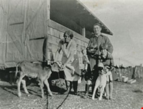
Thould family
https://search.heritageburnaby.ca/link/archivedescription35768
- Repository
- City of Burnaby Archives
- Date
- 1929 (date of original), copied 1986
- Collection/Fonds
- Burnaby Historical Society fonds
- Description Level
- Item
- Physical Description
- 1 photograph : b&w ; 12.7 x 17.8 cm print
- Scope and Content
- Photograph of the Thould family. Back, left to right: Grace Dommett Thould (wife) and Lionel "Judge" Thould (husband). Front left to right: Eileen Thould (daughter), Margaret Thould (daughter), and pet dog, Jack. This photograph was taken at the family's home and farm, 5665 Portland Street in Al…
- Repository
- City of Burnaby Archives
- Date
- 1929 (date of original), copied 1986
- Collection/Fonds
- Burnaby Historical Society fonds
- Subseries
- Pioneer Tales subseries
- Physical Description
- 1 photograph : b&w ; 12.7 x 17.8 cm print
- Description Level
- Item
- Record No.
- 204-626
- Access Restriction
- No restrictions
- Reproduction Restriction
- No known restrictions
- Accession Number
- BHS1988-03
- Scope and Content
- Photograph of the Thould family. Back, left to right: Grace Dommett Thould (wife) and Lionel "Judge" Thould (husband). Front left to right: Eileen Thould (daughter), Margaret Thould (daughter), and pet dog, Jack. This photograph was taken at the family's home and farm, 5665 Portland Street in Alta Vista.
- Media Type
- Photograph
- Notes
- Title based on contents of photograph
- Geographic Access
- Portland Street
- Street Address
- 5665 Portland Street
- Historic Neighbourhood
- Alta-Vista (Historic Neighbourhood)
- Planning Study Area
- Clinton-Glenwood Area
Images
