Narrow Results By
Subject
- Accidents 4
- Accidents - Automobile Accidents
- Accidents - Train Accidents 1
- Advertising Medium - Signs and Signboards
- Aerial Photographs 6
- Agricultural Tools and Equipment 3
- Agricultural Tools and Equipment - Cultivators 1
- Agricultural Tools and Equipment - Gardening Equipment 3
- Agricultural Tools and Equipment - Plows 2
- Agriculture - Crops 9
- Agriculture - Farms 34
- Agriculture - Fruit and Berries 9

1923 Ford Touring Car
https://search.heritageburnaby.ca/link/archivedescription35542
- Repository
- City of Burnaby Archives
- Date
- 1923 (date of original), copied 1986
- Collection/Fonds
- Burnaby Historical Society fonds
- Description Level
- Item
- Physical Description
- 1 photograph : b&w ; 12.7 x 17.8 cm print
- Scope and Content
- Photograph of (left to right) Bill Anthony and Jim Warren, with a 1923 Ford touring car, Jim's first car. They became brothers-in-law when Bill married Mary Warren. The pair are about to leave on motor tour of Oregon.
- Repository
- City of Burnaby Archives
- Date
- 1923 (date of original), copied 1986
- Collection/Fonds
- Burnaby Historical Society fonds
- Subseries
- Pioneer Tales subseries
- Physical Description
- 1 photograph : b&w ; 12.7 x 17.8 cm print
- Description Level
- Item
- Record No.
- 204-400
- Access Restriction
- No restrictions
- Reproduction Restriction
- No known restrictions
- Accession Number
- BHS1988-03
- Scope and Content
- Photograph of (left to right) Bill Anthony and Jim Warren, with a 1923 Ford touring car, Jim's first car. They became brothers-in-law when Bill married Mary Warren. The pair are about to leave on motor tour of Oregon.
- Media Type
- Photograph
- Notes
- Title based on contents of photograph
Images

![Allen Sharpe's First Store on Kingsway, [192-] (date of original), copied 1992 thumbnail](/media/hpo/_Data/_Archives_Images/_Unrestricted/315/315-051.jpg?width=280)
Allen Sharpe's First Store on Kingsway
https://search.heritageburnaby.ca/link/archivedescription36696
- Repository
- City of Burnaby Archives
- Date
- [192-] (date of original), copied 1992
- Collection/Fonds
- Burnaby Historical Society fonds
- Description Level
- Item
- Physical Description
- 1 photograph : b&w ; 13 x 8.5 cm print
- Scope and Content
- Photograph of the exterior of Allen Sharpe's first store on Kingsway (at Kathleen Avenue), a sign shop and store that also sold groceries and Mrs. Rose Sharpe's hand-made linens. The Sharpes bought the property in 1919.
- Repository
- City of Burnaby Archives
- Date
- [192-] (date of original), copied 1992
- Collection/Fonds
- Burnaby Historical Society fonds
- Subseries
- Burnaby Centennial Anthology subseries
- Physical Description
- 1 photograph : b&w ; 13 x 8.5 cm print
- Description Level
- Item
- Record No.
- 315-051
- Access Restriction
- No restrictions
- Reproduction Restriction
- No known restrictions
- Accession Number
- BHS1994-04
- Scope and Content
- Photograph of the exterior of Allen Sharpe's first store on Kingsway (at Kathleen Avenue), a sign shop and store that also sold groceries and Mrs. Rose Sharpe's hand-made linens. The Sharpes bought the property in 1919.
- Names
- Sharpe Signs
- Media Type
- Photograph
- Notes
- Title based on contents of photograph
- Geographic Access
- Kingsway
- Kathleen Avenue
- Street Address
- 4360 Kingsway
- Historic Neighbourhood
- Central Park (Historic Neighbourhood)
- Planning Study Area
- Maywood Area
Images
![Allen Sharpe's First Store on Kingsway, [192-] (date of original), copied 1992 thumbnail](/media/hpo/_Data/_Archives_Images/_Unrestricted/315/315-051.jpg)
![Allen Sharpe's Gas Station on Kingsway, [192-] (date of original), copied 1992 thumbnail](/media/hpo/_Data/_Archives_Images/_Unrestricted/315/315-049.jpg?width=280)
Allen Sharpe's Gas Station on Kingsway
https://search.heritageburnaby.ca/link/archivedescription36694
- Repository
- City of Burnaby Archives
- Date
- [192-] (date of original), copied 1992
- Collection/Fonds
- Burnaby Historical Society fonds
- Description Level
- Item
- Physical Description
- 1 photograph : b&w ; 8.7 x 12.6 cm print
- Scope and Content
- Photograph of Allen Sharpe's gas station on Kingsway (at Kathleen Avenue) with a group of men standing in front. Mr. Sharpe is on the right wearing a cap and tie. Signs on the building read, "Sharpe Service Garage / Shell Gasoline / Motor Oil / Tires."
- Repository
- City of Burnaby Archives
- Date
- [192-] (date of original), copied 1992
- Collection/Fonds
- Burnaby Historical Society fonds
- Subseries
- Burnaby Centennial Anthology subseries
- Physical Description
- 1 photograph : b&w ; 8.7 x 12.6 cm print
- Description Level
- Item
- Record No.
- 315-049
- Access Restriction
- No restrictions
- Reproduction Restriction
- No known restrictions
- Accession Number
- BHS1994-04
- Scope and Content
- Photograph of Allen Sharpe's gas station on Kingsway (at Kathleen Avenue) with a group of men standing in front. Mr. Sharpe is on the right wearing a cap and tie. Signs on the building read, "Sharpe Service Garage / Shell Gasoline / Motor Oil / Tires."
- Names
- Sharpe Service Garage
- Media Type
- Photograph
- Notes
- Title based on contents of photograph
- Geographic Access
- Kingsway
- Street Address
- 4360 Kingsway
- Historic Neighbourhood
- Central Park (Historic Neighbourhood)
- Planning Study Area
- Maywood Area
Images
![Allen Sharpe's Gas Station on Kingsway, [192-] (date of original), copied 1992 thumbnail](/media/hpo/_Data/_Archives_Images/_Unrestricted/315/315-049.jpg)
![Car Accident, [1937 or 1938] (date of original), copied 1991 thumbnail](/media/hpo/_Data/_Archives_Images/_Unrestricted/370/370-548.jpg?width=280)
Car Accident
https://search.heritageburnaby.ca/link/archivedescription37961
- Repository
- City of Burnaby Archives
- Date
- [1937 or 1938] (date of original), copied 1991
- Collection/Fonds
- Burnaby Historical Society fonds
- Description Level
- Item
- Physical Description
- 1 photograph : b&w ; 3.3 x 2.5 cm print on contact sheet 20.6 x 26.1 cm
- Scope and Content
- Photograph of a damaged car belonging to Bob Pontifex, after an accident at Sperling Avenue and Douglas Road.
- Repository
- City of Burnaby Archives
- Date
- [1937 or 1938] (date of original), copied 1991
- Collection/Fonds
- Burnaby Historical Society fonds
- Subseries
- Burnaby Image Bank subseries
- Physical Description
- 1 photograph : b&w ; 3.3 x 2.5 cm print on contact sheet 20.6 x 26.1 cm
- Description Level
- Item
- Record No.
- 370-548
- Access Restriction
- No restrictions
- Reproduction Restriction
- No known restrictions
- Accession Number
- BHS1999-03
- Scope and Content
- Photograph of a damaged car belonging to Bob Pontifex, after an accident at Sperling Avenue and Douglas Road.
- Subjects
- Accidents - Automobile Accidents
- Media Type
- Photograph
- Notes
- Title based on contents of photograph
- 1 b&w copy negative accompanying
- Geographic Access
- Douglas Road
- Sperling Avenue
- Canada Way
- Historic Neighbourhood
- Burnaby Lake (Historic Neighbourhood)
Images
![Car Accident, [1937 or 1938] (date of original), copied 1991 thumbnail](/media/hpo/_Data/_Archives_Images/_Unrestricted/370/370-548.jpg)
![Cascade Drive-In Theatre, [1949] (date of original), copied 1991 thumbnail](/media/hpo/_Data/_Archives_Images/_Unrestricted/370/370-468.jpg?width=280)
Cascade Drive-In Theatre
https://search.heritageburnaby.ca/link/archivedescription37880
- Repository
- City of Burnaby Archives
- Date
- [1949] (date of original), copied 1991
- Collection/Fonds
- Burnaby Historical Society fonds
- Description Level
- Item
- Physical Description
- 1 photograph : b&w ; 3.0 x 4.4 cm print on contact sheet 20.1 x 26.7 cm
- Scope and Content
- Photograph of the Cascade Drive-In Theatre at 4050 Grandview Highway.
- Repository
- City of Burnaby Archives
- Date
- [1949] (date of original), copied 1991
- Collection/Fonds
- Burnaby Historical Society fonds
- Subseries
- Burnaby Image Bank subseries
- Physical Description
- 1 photograph : b&w ; 3.0 x 4.4 cm print on contact sheet 20.1 x 26.7 cm
- Description Level
- Item
- Record No.
- 370-468
- Access Restriction
- No restrictions
- Reproduction Restriction
- Reproduce for fair dealing purposes only
- Accession Number
- BHS1999-03
- Scope and Content
- Photograph of the Cascade Drive-In Theatre at 4050 Grandview Highway.
- Names
- Cascade Drive-In Theatre
- Media Type
- Photograph
- Photographer
- Van Dyke Studios
- Notes
- Title based on contents of photograph
- 1 b&w copy negative accompanying
- Negative has a pink cast
- Geographic Access
- Grandview Highway
- Street Address
- 4050 Grandview Highway
- Historic Neighbourhood
- Broadview (Historic Neighbourhood)
- Planning Study Area
- West Central Valley Area
Images
![Cascade Drive-In Theatre, [1949] (date of original), copied 1991 thumbnail](/media/hpo/_Data/_Archives_Images/_Unrestricted/370/370-468.jpg)

Central Park
https://search.heritageburnaby.ca/link/archivedescription34862
- Repository
- City of Burnaby Archives
- Date
- 1920 (date of original), photographed 1985
- Collection/Fonds
- Burnaby Historical Society fonds
- Description Level
- Item
- Physical Description
- 1 photograph : b&w ; 8.8 x 11.3 cm
- Scope and Content
- Photograph of the Central Park entrance arch with the "Central Park" electric sign. An Interurban tram can be seen on the right. This photograph used to be hung at the Central Park branch of the Burnaby Public Library.
- Repository
- City of Burnaby Archives
- Date
- 1920 (date of original), photographed 1985
- Collection/Fonds
- Burnaby Historical Society fonds
- Subseries
- Evelyn Salisbury subseries
- Physical Description
- 1 photograph : b&w ; 8.8 x 11.3 cm
- Description Level
- Item
- Record No.
- 145-010
- Access Restriction
- No restrictions
- Reproduction Restriction
- No known restrictions
- Accession Number
- BHS1985-15
- Scope and Content
- Photograph of the Central Park entrance arch with the "Central Park" electric sign. An Interurban tram can be seen on the right. This photograph used to be hung at the Central Park branch of the Burnaby Public Library.
- Subjects
- Structures - Arches
- Advertising Medium - Signs and Signboards
- Geographic Features - Parks
- Transportation - Electric Railroads
- Media Type
- Photograph
- Notes
- Title based on contents of photograph
- Geographic Access
- Central Park
- Imperial Street
- Street Address
- 3883 Imperial Street
- Historic Neighbourhood
- Central Park (Historic Neighbourhood)
- Planning Study Area
- Maywood Area
Images


Contractors
https://search.heritageburnaby.ca/link/archivedescription34150
- Repository
- City of Burnaby Archives
- Date
- April 20, 1947
- Collection/Fonds
- Burnaby Historical Society fonds
- Description Level
- Item
- Physical Description
- 1 photograph : b&w negative ; 6.8 x 11.4 cm
- Scope and Content
- Photograph of a sign indexing contractors and their phone numbers. The top of the sign reads: "Whitsell Construction Co. Ltd., General Contractors, Glen. 1434-1435." Others contractors listed are: Clearing and excavating: Holmes & Wilson, BA.0098; Concrete: J. Marcovitch; Brickwork: Selkirk Sadler…
- Repository
- City of Burnaby Archives
- Date
- April 20, 1947
- Collection/Fonds
- Burnaby Historical Society fonds
- Subseries
- Alfred Bingham subseries
- Physical Description
- 1 photograph : b&w negative ; 6.8 x 11.4 cm
- Description Level
- Item
- Record No.
- 010-067
- Access Restriction
- No restrictions
- Reproduction Restriction
- No known restrictions
- Accession Number
- BHS2007-04
- Scope and Content
- Photograph of a sign indexing contractors and their phone numbers. The top of the sign reads: "Whitsell Construction Co. Ltd., General Contractors, Glen. 1434-1435." Others contractors listed are: Clearing and excavating: Holmes & Wilson, BA.0098; Concrete: J. Marcovitch; Brickwork: Selkirk Sadler & Son, KE.1458; Electrical: L.J. McKinnon, PA.2471; Millwork: R.F. Tait Woodworkers, BA.6491; Painting: E. Olsson & Sons Ltd., GL.1434; Plumbing: F. Fenk, DE.3071; Plastering: Turner Bros., FA.2572-4982R; Roofing and strapping: Ray Shaw, FR.4720; Floors: Dunbar Hardwood Floor Ltd., KE.3646; Septic tanks: N. Cosco, BA.4987; Tiling: Darlington Haskins Co. 1943 Ltd., BA.4829. This is part of the Willingdon Heights subdivision site.
- Names
- Darlington Haskins Company
- Dunbar Hardwood Floor Limited
- E. Olsson and Sons Limited
- F. Fenk
- Holmes and Wilson Trucking Company Limited
- L.J. McKinnon
- Cosco, N.
- Ray Shaw
- R.F. Tait Woodworkers
- Selkirk Sadler and Son
- Turner Brothers
- Whitsell Construction Company Limited
- Marcovitch, J.
- Media Type
- Photograph
- Photographer
- Bingham, Alfred "Alf"
- Notes
- Title based on contents of photograph
Images

Edna and Bill Maggs
https://search.heritageburnaby.ca/link/archivedescription37082
- Repository
- City of Burnaby Archives
- Date
- 1942 (date of original), copied 1992
- Collection/Fonds
- Burnaby Historical Society fonds
- Description Level
- Item
- Physical Description
- 1 photograph : b&w ; 8.8 x 12.6 cm print
- Scope and Content
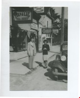
- Photograph of husband and wife, Bill and Edna Maggs, beside the Burnaby Shoe Hospital and Mr. Shewbrook's insurance office shortly after their wedding.
- Repository
- City of Burnaby Archives
- Date
- 1942 (date of original), copied 1992
- Collection/Fonds
- Burnaby Historical Society fonds
- Subseries
- Burnaby Centennial Anthology subseries
- Physical Description
- 1 photograph : b&w ; 8.8 x 12.6 cm print
- Description Level
- Item
- Record No.
- 315-545
- Access Restriction
- No restrictions
- Reproduction Restriction
- No known restrictions
- Accession Number
- BHS1994-04
- Scope and Content
- Photograph of husband and wife, Bill and Edna Maggs, beside the Burnaby Shoe Hospital and Mr. Shewbrook's insurance office shortly after their wedding.
- Names
- Maggs, Bill
- Trehearne, Edna Jean Mayhew Maggs
- Burnaby Shoe Hospital
- Shewbrooks Real Estate and Insurance
- Media Type
- Photograph
- Notes
- Title based on contents of photograph
- Geographic Access
- Kingsway
- Street Address
- 4539 Kingsway
- Historic Neighbourhood
- Central Park (Historic Neighbourhood)
- Planning Study Area
- Marlborough Area
Images

![Grace Price and her son, [1939] (date of original), copied 1992 thumbnail](/media/hpo/_Data/_Archives_Images/_Unrestricted/315/315-455.jpg?width=280)
Grace Price and her son
https://search.heritageburnaby.ca/link/archivedescription36997
- Repository
- City of Burnaby Archives
- Date
- [1939] (date of original), copied 1992
- Collection/Fonds
- Burnaby Historical Society fonds
- Description Level
- Item
- Physical Description
- 1 photograph : b&w ; 8.2 x 12.7 cm print
- Scope and Content
- Photograph of Grace Price and her son, David Price, walking down the street. Signs on the buildings behind them read, "National Clothes Shop" and "Offices to rent in this building."
- Repository
- City of Burnaby Archives
- Date
- [1939] (date of original), copied 1992
- Collection/Fonds
- Burnaby Historical Society fonds
- Subseries
- Burnaby Centennial Anthology subseries
- Physical Description
- 1 photograph : b&w ; 8.2 x 12.7 cm print
- Description Level
- Item
- Record No.
- 315-455
- Access Restriction
- No restrictions
- Reproduction Restriction
- No known restrictions
- Accession Number
- BHS1994-04
- Scope and Content
- Photograph of Grace Price and her son, David Price, walking down the street. Signs on the buildings behind them read, "National Clothes Shop" and "Offices to rent in this building."
- Media Type
- Photograph
- Notes
- Title based on contents of photograph
Images
![Grace Price and her son, [1939] (date of original), copied 1992 thumbnail](/media/hpo/_Data/_Archives_Images/_Unrestricted/315/315-455.jpg)

Grant family home
https://search.heritageburnaby.ca/link/archivedescription36865
- Repository
- City of Burnaby Archives
- Date
- 1925
- Collection/Fonds
- Burnaby Historical Society fonds
- Description Level
- Item
- Physical Description
- 1 photograph : b&w ; 8.7 x 12.7 cm print
- Scope and Content
- Photograph of the playroom of the Grant family home at 2772 Sussex Avenue (old street numbering). In the room is a sign for the Imperial Order Daughters of the Empire (I.O.D.E.) with which Mrs. Grant was involved. Alice and George A. Grant moved here with their family in 1925.
- Repository
- City of Burnaby Archives
- Date
- 1925
- Collection/Fonds
- Burnaby Historical Society fonds
- Subseries
- Burnaby Centennial Anthology subseries
- Physical Description
- 1 photograph : b&w ; 8.7 x 12.7 cm print
- Description Level
- Item
- Record No.
- 315-323
- Access Restriction
- No restrictions
- Reproduction Restriction
- No known restrictions
- Accession Number
- BHS1994-04
- Scope and Content
- Photograph of the playroom of the Grant family home at 2772 Sussex Avenue (old street numbering). In the room is a sign for the Imperial Order Daughters of the Empire (I.O.D.E.) with which Mrs. Grant was involved. Alice and George A. Grant moved here with their family in 1925.
- Media Type
- Photograph
- Notes
- Title based on contents of photograph
- Geographic Access
- Sussex Avenue
- Kingsway
- Street Address
- 4700 Kingsway
- Historic Neighbourhood
- Central Park (Historic Neighbourhood)
- Planning Study Area
- Maywood Area
Images


Heyworth family
https://search.heritageburnaby.ca/link/archivedescription35072
- Repository
- City of Burnaby Archives
- Date
- 1939 (date of original), copied 1986
- Collection/Fonds
- Burnaby Historical Society fonds
- Description Level
- Item
- Physical Description
- 1 photograph : b&w negative ; 9.0 x 6.0 cm
- Scope and Content
- Photograph of Mr. and Mrs. [G.R.] Heyworth and "Aunt Betty" outside standing outside Jubilee Drug Store, Jubilee Avenue and Imperial Street (later the location of Bonsor Park, 6550 Bonsor Avenue). An electric sign reads, "Rexall Drugs." A dog can be seen at the bottom of the photograph. An accom…
- Repository
- City of Burnaby Archives
- Date
- 1939 (date of original), copied 1986
- Collection/Fonds
- Burnaby Historical Society fonds
- Subseries
- Heyworth family subseries
- Physical Description
- 1 photograph : b&w negative ; 9.0 x 6.0 cm
- Description Level
- Item
- Record No.
- 187-005
- Access Restriction
- No restrictions
- Reproduction Restriction
- No known restrictions
- Accession Number
- BHS1986-38
- Scope and Content
- Photograph of Mr. and Mrs. [G.R.] Heyworth and "Aunt Betty" outside standing outside Jubilee Drug Store, Jubilee Avenue and Imperial Street (later the location of Bonsor Park, 6550 Bonsor Avenue). An electric sign reads, "Rexall Drugs." A dog can be seen at the bottom of the photograph. An accompanying letter describes the photo as "Dad with Mother and Aunt Betty. They had just walked back from Kingsway after seeing the King and Queen pass - 1937 [sic; the royal visit was in 1939]."
- Subjects
- Animals - Dogs
- Buildings - Commercial - Drugstores
- Advertising Medium - Signs and Signboards
- Media Type
- Photograph
- Notes
- Title based on contents of photograph
- 1 b&w copy print accompanying
- Geographic Access
- Jubilee Avenue
- Bonsor Avenue
- Street Address
- 6550 Bonsor Avenue
- Historic Neighbourhood
- Central Park (Historic Neighbourhood)
- Planning Study Area
- Marlborough Area
Images

![Hickman Family Store, [1940] (date of original), copied 1986 thumbnail](/media/hpo/_Data/_Archives_Images/_Unrestricted/204/204-243.jpg?width=280)
Hickman Family Store
https://search.heritageburnaby.ca/link/archivedescription35386
- Repository
- City of Burnaby Archives
- Date
- [1940] (date of original), copied 1986
- Collection/Fonds
- Burnaby Historical Society fonds
- Description Level
- Item
- Physical Description
- 1 photograph : b&w ; 12.7 x 17.8 cm print
- Scope and Content
- Photograph of the exterior of Hickmans Market. This store was owned and operated by Alf Hickman and was located on Patterson Avenue (later numbered 5932 Patterson Avenue).
- Repository
- City of Burnaby Archives
- Date
- [1940] (date of original), copied 1986
- Collection/Fonds
- Burnaby Historical Society fonds
- Subseries
- Pioneer Tales subseries
- Physical Description
- 1 photograph : b&w ; 12.7 x 17.8 cm print
- Description Level
- Item
- Record No.
- 204-243
- Access Restriction
- No restrictions
- Reproduction Restriction
- No known restrictions
- Accession Number
- BHS1988-03
- Scope and Content
- Photograph of the exterior of Hickmans Market. This store was owned and operated by Alf Hickman and was located on Patterson Avenue (later numbered 5932 Patterson Avenue).
- Names
- Hickman and Son Market
- Media Type
- Photograph
- Notes
- Title based on contents of photograph
- Geographic Access
- Patterson Avenue
- Street Address
- 5932 Patterson Avenue
- Historic Neighbourhood
- Central Park (Historic Neighbourhood)
- Planning Study Area
- Maywood Area
Images
![Hickman Family Store, [1940] (date of original), copied 1986 thumbnail](/media/hpo/_Data/_Archives_Images/_Unrestricted/204/204-243.jpg)

The Hot Dog Inn and proprietors
https://search.heritageburnaby.ca/link/archivedescription34311
- Repository
- City of Burnaby Archives
- Date
- 1924
- Collection/Fonds
- Burnaby Historical Society fonds
- Description Level
- Item
- Physical Description
- 1 photograph : b&w ; 8 x 12.9 cm on page 17.5 x 24.5 cm
- Scope and Content
- Photograph of the hot dog stand built at Deer Lake for ice skaters. Standing in front of it are the "proprietors" A. D. Bowker and Abe Rowe. The sign affixed to the stand reads: "This Is The Hot Dog Inn And It's Cold Outside / Come Right In / Coffee 5 cents / Hot Dogs 10 cents".
- Repository
- City of Burnaby Archives
- Date
- 1924
- Collection/Fonds
- Burnaby Historical Society fonds
- Subseries
- Peers family subseries
- Physical Description
- 1 photograph : b&w ; 8 x 12.9 cm on page 17.5 x 24.5 cm
- Description Level
- Item
- Record No.
- 020-018
- Access Restriction
- No restrictions
- Reproduction Restriction
- No known restrictions
- Accession Number
- BHS2007-04
- Scope and Content
- Photograph of the hot dog stand built at Deer Lake for ice skaters. Standing in front of it are the "proprietors" A. D. Bowker and Abe Rowe. The sign affixed to the stand reads: "This Is The Hot Dog Inn And It's Cold Outside / Come Right In / Coffee 5 cents / Hot Dogs 10 cents".
- Subjects
- Buildings - Commercial - Restaurants
- Structures - Tents
- Advertising Medium - Signs and Signboards
- Names
- Bowker, A.D.
- Rowe, Abe
- Media Type
- Photograph
- Notes
- Title based on caption accompanying photograph
- Geographic Access
- Deer Lake
- Historic Neighbourhood
- Burnaby Lake (Historic Neighbourhood)
- Planning Study Area
- Morley-Buckingham Area
Images


Interview with Don Brown by Rod Fowler February 26, 1990 - Track 6
https://search.heritageburnaby.ca/link/oralhistory507
- Repository
- City of Burnaby Archives
- Date Range
- 1947-1954
- Length
- 00:05:44
- Summary
- This portion of the interview is about the paving and widening of Kingsway in 1953, the development along main roads, and the end of the Interurban tram system
- Repository
- City of Burnaby Archives
- Summary
- This portion of the interview is about the paving and widening of Kingsway in 1953, the development along main roads, and the end of the Interurban tram system
- Date Range
- 1947-1954
- Photo Info
- Royal Canadian Mounted Police Sergeant Don Brown, November 2, 1997. Item no. 535-0979
- Length
- 00:05:44
- Subjects
- Accidents - Automobile Accidents
- Transportation - Automobiles
- Transportation - Electric Railroads
- Interviewer
- Fowler, Rod
- Interview Date
- February 26, 1990
- Scope and Content
- Recording is of an interview with Don Brown, conducted by Rod Fowler. Don Brown was one of eleven participants interviewed as part of the SFU/Burnaby Centennial Committee's oral history series titled, "Voices of Burnaby". The interview is mainly about Don Brown’s description of the changes in Burnaby’s built and natural landscapes and socioeconomic conditions, especially between 1947 and 1975, the strong impression made on him by those changes evident in the interview. He talks about his work and career as a police officer with the Burnaby Provincial Police and RCMP. The interview also details his involvement in Burnaby politics and volunteer community groups. To view “Narrow By” terms for each track expand this description and see “Notes”.
- Biographical Notes
- Donald Neil “Don” Brown was born in Birmingham, England May 4, 1919, and immigrated with his parents and siblings to Winnipeg in 1922. At the outbreak of WWII Don Brown left high school and enlisted in the 12th Field Company, Royal Canadian Engineers, serving six years in the army. Before going overseas he married Helen Birch in 1939. In 1947 Don Brown joined the B.C. Provincial Police which was absorbed by the RCMP in 1950. He worked as a police officer in Burnaby from 1947 to 1954, and then was transferred to Ottawa (with a stop in Regina) for nine and a half years where he attended Carleton University to study forensics. In 1963 Don Brown was transferred back to Vancouver and bought and moved into a house on Watling Street in Burnaby where he still lived in 1990. Another transfer took him to Edmonton for five years, returning to Burnaby in 1975. Following retirement in 1980 with the rank of Supervisor and after 22 years in forensic laboratories, Don Brown started his own business as a private document examiner. Don Brown was active in Burnaby politics, serving as Alderman from 1979-1985. He was also involved in many community groups including the South Burnaby Men’s Club, which he helped found in 1952, as well as active in the Burnaby Historical Society, and served on the Burnaby School Board, Burnaby Centennial Committee, and the Community College for the Retired. Don and Helen Brown had six children: Donna, Don, Gina, Patricia, Christopher and Susan. Don Brown died May 16, 2009.
- Total Tracks
- 14
- Total Length
- 01:35:07
- Interviewee Name
- Brown, Donald N. "Don"
- Interviewer Bio
- Rod Fowler returned to university as a mature student in the 1980s after working about twenty years in the field of economics and computerization in business in England, Europe and Western Canada. He graduated with a BA from SFU in both History and Sociology in 1987, his MA degree in Geography in 1989, and his PhD in Cultural Geography at SFU. He taught courses in Geography, Sociology, History and Canadian Studies at several Lower Mainland colleges, before becoming a full time member of the Geography Department at Kwantlen University College.
- Collection/Fonds
- SFU/Burnaby Centennial Committee fonds
- Transcript Available
- Transcript available
- Media Type
- Sound Recording
- Web Notes
- Interviews were digitized in 2015 allowing them to be accessible on Heritage Burnaby. The digitization project was initiated by the Community Heritage Commission with support from City of Burnaby Council.
Images

Audio Tracks
Track six of interview with Don Brown
Track six of interview with Don Brown
https://search.heritageburnaby.ca/media/hpo/_Data/_Archives_Oral_Histories/_Unrestricted/MSS187-016/MSS187-016_Track%206.mp3![Jubilee Avenue, [192-] (date of original), copied 1986 thumbnail](/media/hpo/_Data/_Archives_Images/_Unrestricted/126/187-002.jpg?width=280)
Jubilee Avenue
https://search.heritageburnaby.ca/link/archivedescription35069
- Repository
- City of Burnaby Archives
- Date
- [192-] (date of original), copied 1986
- Collection/Fonds
- Burnaby Historical Society fonds
- Description Level
- Item
- Physical Description
- 1 photograph : b&w ; 11.4 x 7.1 cm
- Scope and Content
- Photograph of stores on Jubilee Avenue looking north from Imperial Street (later the location of Bonsor Park, 6550 Bonsor Avenue). Signs visible read; "Jubilee Drug Store," "Drugs," "Jubilee [Mercantile?] Co. / Groceries," "Nabob Tea," and "[Carvers or Corvers]." An accompanying description in the…
- Repository
- City of Burnaby Archives
- Date
- [192-] (date of original), copied 1986
- Collection/Fonds
- Burnaby Historical Society fonds
- Subseries
- Heyworth family subseries
- Physical Description
- 1 photograph : b&w ; 11.4 x 7.1 cm
- Description Level
- Item
- Record No.
- 187-002
- Access Restriction
- No restrictions
- Reproduction Restriction
- No known restrictions
- Accession Number
- BHS1986-38
- Scope and Content
- Photograph of stores on Jubilee Avenue looking north from Imperial Street (later the location of Bonsor Park, 6550 Bonsor Avenue). Signs visible read; "Jubilee Drug Store," "Drugs," "Jubilee [Mercantile?] Co. / Groceries," "Nabob Tea," and "[Carvers or Corvers]." An accompanying description in the accession file states that a man named Pat Flannagan ran the grocery.
- Media Type
- Photograph
- Notes
- Title based on contents of photograph
- Stamp on verso of photograph reads: "5272"
- Geographic Access
- Jubilee Avenue
- Bonsor Avenue
- Street Address
- 6550 Bonsor Avenue
- Historic Neighbourhood
- Central Park (Historic Neighbourhood)
- Planning Study Area
- Marlborough Area
Images
![Jubilee Avenue, [192-] (date of original), copied 1986 thumbnail](/media/hpo/_Data/_Archives_Images/_Unrestricted/126/187-002.jpg)

Kask's Filling Station
https://search.heritageburnaby.ca/link/archivedescription35533
- Repository
- City of Burnaby Archives
- Date
- 1930 (date of original), copied 1986
- Collection/Fonds
- Burnaby Historical Society fonds
- Description Level
- Item
- Physical Description
- 1 photograph : b&w ; 12.7 x 17.8 cm print
- Scope and Content
- Photograph of Kask's Filling Station, Kask's Camp, Barnet Road. It was located next to Kask's General Store to serve residents of the 30 to 35 rental cabins, plus the Kask home. The Kasks also operated a steam bath.
- Repository
- City of Burnaby Archives
- Date
- 1930 (date of original), copied 1986
- Collection/Fonds
- Burnaby Historical Society fonds
- Subseries
- Pioneer Tales subseries
- Physical Description
- 1 photograph : b&w ; 12.7 x 17.8 cm print
- Description Level
- Item
- Record No.
- 204-391
- Access Restriction
- No restrictions
- Reproduction Restriction
- No known restrictions
- Accession Number
- BHS1988-03
- Scope and Content
- Photograph of Kask's Filling Station, Kask's Camp, Barnet Road. It was located next to Kask's General Store to serve residents of the 30 to 35 rental cabins, plus the Kask home. The Kasks also operated a steam bath.
- Subjects
- Buildings - Commercial - General Stores
- Advertising Medium - Signs and Signboards
- Buildings - Commercial - Service Stations
- Media Type
- Photograph
- Notes
- Title based on contents of photograph
- Geographic Access
- Barnet Road
- Street Address
- 7501 Barnet Road
- Historic Neighbourhood
- Barnet (Historic Neighbourhood)
- Planning Study Area
- Burnaby Mountain Area
Images


Kingsway
https://search.heritageburnaby.ca/link/archivedescription34510
- Repository
- City of Burnaby Archives
- Date
- 1920
- Collection/Fonds
- Burnaby Historical Society fonds
- Description Level
- Item
- Physical Description
- 1 photograph : sepia ; 12.6 x 17.7 cm
- Scope and Content
- Photograph of Kingsway looking east at Boundary Road. A sign on the right reads, "Burnaby / Vehicles must slow down at all schools and intersections marked thus: X." A sign on a building at the left reads, "Arctic Ice Cream." Central Park is on the right.
- Repository
- City of Burnaby Archives
- Date
- 1920
- Collection/Fonds
- Burnaby Historical Society fonds
- Subseries
- Photographs subseries
- Physical Description
- 1 photograph : sepia ; 12.6 x 17.7 cm
- Description Level
- Item
- Record No.
- 031-001
- Access Restriction
- No restrictions
- Reproduction Restriction
- No known restrictions
- Accession Number
- BHS2007-04
- Scope and Content
- Photograph of Kingsway looking east at Boundary Road. A sign on the right reads, "Burnaby / Vehicles must slow down at all schools and intersections marked thus: X." A sign on a building at the left reads, "Arctic Ice Cream." Central Park is on the right.
- Media Type
- Photograph
- Notes
- Title based on contents of photograph
- Geographic Access
- Kingsway
- Central Park
- Boundary Road
- Historic Neighbourhood
- Central Park (Historic Neighbourhood)
- Planning Study Area
- Garden Village Area
- Maywood Area
Images


Kingsway
https://search.heritageburnaby.ca/link/archivedescription34511
- Repository
- City of Burnaby Archives
- Date
- 1920
- Collection/Fonds
- Burnaby Historical Society fonds
- Description Level
- Item
- Physical Description
- 1 photograph : sepia ; 12.6 x 17.6 cm
- Scope and Content
- Photograph of Kingsway looking east at Boundary Road. A sign on the right reads, "Burnaby / Vehicles must slow down at all schools and intersections marked thus: X." A sign on a building at the left reads, "Arctic Ice Cream." Central Park is on the right.
- Repository
- City of Burnaby Archives
- Date
- 1920
- Collection/Fonds
- Burnaby Historical Society fonds
- Subseries
- Photographs subseries
- Physical Description
- 1 photograph : sepia ; 12.6 x 17.6 cm
- Description Level
- Item
- Record No.
- 031-002
- Access Restriction
- No restrictions
- Reproduction Restriction
- No known restrictions
- Accession Number
- BHS2007-04
- Scope and Content
- Photograph of Kingsway looking east at Boundary Road. A sign on the right reads, "Burnaby / Vehicles must slow down at all schools and intersections marked thus: X." A sign on a building at the left reads, "Arctic Ice Cream." Central Park is on the right.
- Subjects
- Geographic Features - Roads
- Advertising Medium - Signs and Signboards
- Transportation - Automobiles
- Media Type
- Photograph
- Notes
- Title based on contents of photograph
- Geographic Access
- Kingsway
- Central Park
- Boundary Road
- Historic Neighbourhood
- Central Park (Historic Neighbourhood)
- Planning Study Area
- Garden Village Area
- Maywood Area
Images


Matheson and Sons Market
https://search.heritageburnaby.ca/link/archivedescription35041
- Repository
- City of Burnaby Archives
- Date
- 1949 (date of original), copied 1986
- Collection/Fonds
- Burnaby Historical Society fonds
- Description Level
- Item
- Physical Description
- 1 photograph : col. ; 8.6 x 12.7 cm print
- Scope and Content
- Photograph of the exterior of A. Matheson and Sons Market at 3576 Kingsway (later renumbered 4920 Kingsway) and Nelson Avenue. Signs on the building read, "A. Matheson & Sons Market," "Fresh Meats - Groceries," "Quality and Service," "Dexter 1372 1373," and "Free Delivery." Signs advertising pric…
- Repository
- City of Burnaby Archives
- Date
- 1949 (date of original), copied 1986
- Collection/Fonds
- Burnaby Historical Society fonds
- Subseries
- Chamberlain family subseries
- Physical Description
- 1 photograph : col. ; 8.6 x 12.7 cm print
- Description Level
- Item
- Record No.
- 179-012
- Access Restriction
- No restrictions
- Reproduction Restriction
- Reproduce for fair dealing purposes only
- Accession Number
- BHS1986-27
- Scope and Content
- Photograph of the exterior of A. Matheson and Sons Market at 3576 Kingsway (later renumbered 4920 Kingsway) and Nelson Avenue. Signs on the building read, "A. Matheson & Sons Market," "Fresh Meats - Groceries," "Quality and Service," "Dexter 1372 1373," and "Free Delivery." Signs advertising prices are outside the store. A sign by the street lights reads, "Signals set for 29 mph." Cars can be seen. This store was previously owned and operated by Alexander MacKenzie.
- Media Type
- Photograph
- Notes
- Title based on contents of photograph
- Print made from col. slide
- Geographic Access
- Kingsway
- Street Address
- 4920 Kingsway
- Historic Neighbourhood
- Central Park (Historic Neighbourhood)
- Planning Study Area
- Marlborough Area
Images


Matheson and Sons Market
https://search.heritageburnaby.ca/link/archivedescription35042
- Repository
- City of Burnaby Archives
- Date
- 1949 (date of original), copied 1986
- Collection/Fonds
- Burnaby Historical Society fonds
- Description Level
- Item
- Physical Description
- 1 photograph : col. ; 8.8 x 12.6 cm print
- Scope and Content
- Photograph of the exterior of A. Matheson and Sons Market at 3576 Kingsway (later renumbered 4920 Kingsway) and Nelson Avenue. Signs on the building read, "A. Matheson & Sons Market," "Fresh Meats - Groceries," "Quality and Service," "Dexter 1372 1373," and "Free Delivery." Signs advertising pric…
- Repository
- City of Burnaby Archives
- Date
- 1949 (date of original), copied 1986
- Collection/Fonds
- Burnaby Historical Society fonds
- Subseries
- Chamberlain family subseries
- Physical Description
- 1 photograph : col. ; 8.8 x 12.6 cm print
- Description Level
- Item
- Record No.
- 179-013
- Access Restriction
- No restrictions
- Reproduction Restriction
- Reproduce for fair dealing purposes only
- Accession Number
- BHS1986-27
- Scope and Content
- Photograph of the exterior of A. Matheson and Sons Market at 3576 Kingsway (later renumbered 4920 Kingsway) and Nelson Avenue. Signs on the building read, "A. Matheson & Sons Market," "Fresh Meats - Groceries," "Quality and Service," "Dexter 1372 1373," and "Free Delivery." Signs advertising prices are outside the store. A sign by the street lights reads, "Signals set for 29 mph." This store was previously owned and operated by Alexander MacKenzie.
- Media Type
- Photograph
- Notes
- Title based on contents of photograph
- Print made from col. slide
- Geographic Access
- Kingsway
- Street Address
- 4920 Kingsway
- Historic Neighbourhood
- Central Park (Historic Neighbourhood)
- Planning Study Area
- Marlborough Area
Images
