Narrow Results By
Decade
- 2020s 231
- 2010s 263
- 2000s 1472
- 1990s 2898
- 1980s 1270
- 1970s 2965
- 1960s 1151
- 1950s 1504
- 1940s 1622
- 1930s 1602
- 1920s 1794
- 1910s
- 1900s 669
- 1890s 173
- 1880s 107
- 1870s 18
- 1860s 23
- 1850s 10
- 1840s 6
- 1830s 3
- 1820s 3
- 1810s 4
- 1800s 4
- 1790s 3
- 1780s 3
- 1770s 3
- 1760s 3
- 1750s 3
- 1740s 3
- 1730s 3
- 1720s 3
- 1710s 3
- 1700s 3
- 1690s 3
- 1680s 3
- 1670s 2
- 1660s 2
- 1650s 2
- 1640s 2
- 1630s 2
- 1620s 2
- 1610s 2
- 1600s 2
- 1590s 1
- 1580s 1
- 1570s
- 1560s 1
- 1550s 1
- 1540s 1
- 1530s 1
- 1520s 2
- 1510s 1
- 1500s 1
- 1490s 1
- 1480s 1
Subject
- Accidents - Train Accidents 1
- Advertising Medium 1
- Advertising Medium - Signs and Signboards 8
- Agricultural Tools and Equipment 1
- Agricultural Tools and Equipment - Gardening Equipment 3
- Agricultural Tools and Equipment - Plows 3
- Agriculture 1
- Agriculture - Crops 5
- Agriculture - Farms 21
- Agriculture - Fruit and Berries 5
- Agriculture - Orchards 1
- Animals 1
Creator
- Addington, H.E. 1
- Alberta Photo Company 1
- Barrowclough, G.A. 3
- Barrowclough, George Alfred 5
- Broadbridge Commercial Photo Company 1
- Brown, Cice Chandler 1
- Brown, W. 3
- Brown, William Thomas 2
- Bullen & Lamb 1
- Burnaby Village Museum 5
- Burnett and McGugan B.C. Land Surveyors, New Westminster 5
- Burnett, Geoffrey K. 5
![Edmonds Area in Burnaby, [1910] (date of original), copied 1977 thumbnail](/media/hpo/_Data/_BVM_Images/1977/1977_0099_0020_001.jpg?width=280)
Edmonds Area in Burnaby
https://search.heritageburnaby.ca/link/museumdescription578
- Repository
- Burnaby Village Museum
- Date
- [1910] (date of original), copied 1977
- Collection/Fonds
- Burnaby Village Museum Photograph collection
- Description Level
- Item
- Physical Description
- 1 photograph : b&w ; 20.2 x 25.2 cm print
- Scope and Content
- Photograph of the Edmonds Street area. There are a few buildings, including houses, built along the road that is lined with large electric power poles. Near the centre a tram is going by a landmark building that was located on the corner of Edmonds Street and Kingsway known as the Edmonds Block.
- Repository
- Burnaby Village Museum
- Collection/Fonds
- Burnaby Village Museum Photograph collection
- Description Level
- Item
- Physical Description
- 1 photograph : b&w ; 20.2 x 25.2 cm print
- Scope and Content
- Photograph of the Edmonds Street area. There are a few buildings, including houses, built along the road that is lined with large electric power poles. Near the centre a tram is going by a landmark building that was located on the corner of Edmonds Street and Kingsway known as the Edmonds Block.
- Subjects
- Transportation - Electric Railroads
- Geographic Access
- Edmonds Street
- Kingsway
- Accession Code
- HV977.99.20
- Access Restriction
- No restrictions
- Reproduction Restriction
- May be restricted by third party rights
- Date
- [1910] (date of original), copied 1977
- Media Type
- Photograph
- Historic Neighbourhood
- Edmonds (Historic Neighbourhood)
- Planning Study Area
- Richmond Park Area
- Scan Resolution
- 600
- Scan Date
- 2023-07-11
- Notes
- Title based on contents of photograph
Images
![Edmonds Area in Burnaby, [1910] (date of original), copied 1977 thumbnail](/media/hpo/_Data/_BVM_Images/1977/1977_0099_0020_001.jpg)
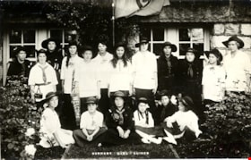
First Burnaby Girl Guide Company
https://search.heritageburnaby.ca/link/museumdescription4915
- Repository
- Burnaby Village Museum
- Date
- 1918
- Collection/Fonds
- Burnaby Girl Guides fonds
- Description Level
- Item
- Physical Description
- 1 photograph : b&w postcard ; 9 x 14 cm
- Scope and Content
- Photograph of the 1st Burnaby Girl Guide Company in uniform in front of the Burnaby Municipal Hall at Edmond's.
- Repository
- Burnaby Village Museum
- Collection/Fonds
- Burnaby Girl Guides fonds
- Description Level
- Item
- Physical Description
- 1 photograph : b&w postcard ; 9 x 14 cm
- Scope and Content
- Photograph of the 1st Burnaby Girl Guide Company in uniform in front of the Burnaby Municipal Hall at Edmond's.
- Names
- Girl Guides of Canada
- Accession Code
- BV015.35.273
- Access Restriction
- No restrictions
- Reproduction Restriction
- No known restrictions
- Date
- 1918
- Media Type
- Photograph
- Historic Neighbourhood
- Edmonds (Historic Neighbourhood)
- Planning Study Area
- Maywood Area
- Scan Resolution
- 600
- Scan Date
- January 6, 2021
- Scale
- 100
- Notes
- Title based on contents of photograph
- Handwritten annotation in red pencil in bottom right corner of photograph reads: "1918"
- Stamp on verso of postcard reads: "POST CARD / PLACE STAMP HERE / MADE IN CANADA / CORRESPONDENCE HERE / NAME AND ADDRESS HERE"
- Photograph is a part of scrapbook "Burnaby Girl Guides. -- [1914]-1969, predominant ca. 1920" (BV.015.35.164)
Images

First Burnaby Girl Guide Company in Central Park
https://search.heritageburnaby.ca/link/museumdescription4906
- Repository
- Burnaby Village Museum
- Date
- 1 Jul 1916
- Collection/Fonds
- Burnaby Girl Guides fonds
- Description Level
- Item
- Physical Description
- 1 photograph : sepia ; 16.5 x 21.5 cm
- Scope and Content
- Photograph of the 1st Burnaby Company in Central Park in Burnaby. The girl guides are dressed in white uniforms and are gathered together for a group photograph in a clearing in the woods. One of the girls at the centre of the group is holding a commonwealth flag.
- Repository
- Burnaby Village Museum
- Collection/Fonds
- Burnaby Girl Guides fonds
- Description Level
- Item
- Physical Description
- 1 photograph : sepia ; 16.5 x 21.5 cm
- Scope and Content
- Photograph of the 1st Burnaby Company in Central Park in Burnaby. The girl guides are dressed in white uniforms and are gathered together for a group photograph in a clearing in the woods. One of the girls at the centre of the group is holding a commonwealth flag.
- Names
- Girl Guides of Canada
- Geographic Access
- Central Park
- Accession Code
- BV015.35.264
- Access Restriction
- No restrictions
- Reproduction Restriction
- No known restrictions
- Date
- 1 Jul 1916
- Media Type
- Photograph
- Historic Neighbourhood
- Central Park (Historic Neighbourhood)
- Planning Study Area
- Maywood Area
- Scan Resolution
- 600
- Scan Date
- January 6, 2021
- Scale
- 100
- Notes
- Title based on contents of photograph
- Note in blue ink on verso of photograph reads: "Central Park, Burnaby / July 1, 1916 / 1st Burnaby Company"
- Stamp on verso of photograph reads: "FRANCEL MORKILL / GIRL GUIDE LIBRARY"
- Signature in blue ink on verso of photograph reads: "Amy Leigh"
- Notes in red pencil on verso of photograph read: "8 _ 50%"
- Photograph is a part of scrapbook "Burnaby Girl Guides. -- [1914]-1969, predominant ca. 1920" (BV.015.35.164)
Images
![First Burnaby Girl Guides Company, [1919] (date of original), copied [1972] thumbnail](/media/hpo/_Data/_BVM_Images/1972/1972_0051_0001_001.jpg?width=280)
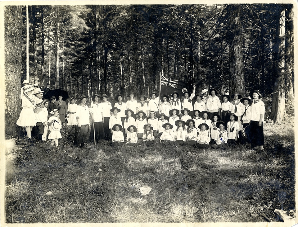
First Burnaby Girl Guides Company
https://search.heritageburnaby.ca/link/museumdescription1080
- Repository
- Burnaby Village Museum
- Date
- [1919] (date of original), copied [1972]
- Collection/Fonds
- Burnaby Village Museum Photograph collection
- Description Level
- Item
- Physical Description
- 1 photograph : b&w ; 16.6 x 21.5 cm print
- Scope and Content
- Photograph of the eighteen girls of the first Burnaby Girl Guide Company. The girl guide flag with a clover leaf symbol in the centre, and writing, "1st Burnaby Company" at the top, is hanging on a staff behind the girls. An earlier catalogue record from 1976 notes that the brick building behind t…
- Repository
- Burnaby Village Museum
- Collection/Fonds
- Burnaby Village Museum Photograph collection
- Description Level
- Item
- Physical Description
- 1 photograph : b&w ; 16.6 x 21.5 cm print
- Scope and Content
- Photograph of the eighteen girls of the first Burnaby Girl Guide Company. The girl guide flag with a clover leaf symbol in the centre, and writing, "1st Burnaby Company" at the top, is hanging on a staff behind the girls. An earlier catalogue record from 1976 notes that the brick building behind the girls would almost certainly be the Burnaby Municipal Hall built in 1911, from having examined the detail of the brickwork, the stonework of the foundations and the joinery around the windows of the basement. One of the girls is holding a pennant with the Union Jack at one end and the word "Welcome" in the fly. The 1976 record surmises that this might be for the visit of the Prince Wales in 1919. The girls' uniforms consist mostly of white middies, long dark skirts and Australian-style Stetsons. Some girls are wearing dark dresses with a belt at the waist and a knotted scarf at the neck. The skirts are mid-calf. The Girl Guides first formed in Burnaby in 1914, and worked on making and sending gifts to the soldiers in their war efforts. An annotation on the back of the photograph reads, "300 out."
- Geographic Access
- Kingsway
- Street Address
- 7282 Kingsway
- Accession Code
- HV972.51.1
- Access Restriction
- No restrictions
- Reproduction Restriction
- No known restrictions
- Date
- [1919] (date of original), copied [1972]
- Media Type
- Photograph
- Historic Neighbourhood
- Edmonds (Historic Neighbourhood)
- Planning Study Area
- Stride Avenue Area
- Scan Resolution
- 600
- Scan Date
- 2023-04-04
- Notes
- Title based on contents of photograph
Images
![First Burnaby Girl Guides Company, [1919] (date of original), copied [1972] thumbnail](/media/hpo/_Data/_BVM_Images/1972/1972_0051_0001_001.jpg)
![House at Buena Vista, Burnaby, [between 1912 and 1925] thumbnail](/media/hpo/_Data/_BVM_Images/1984/1984_0051_0019_001.jpg?width=280)
House at Buena Vista, Burnaby
https://search.heritageburnaby.ca/link/museumdescription247
- Repository
- Burnaby Village Museum
- Date
- [between 1912 and 1925]
- Collection/Fonds
- Burnaby Village Museum Photograph collection
- Description Level
- Item
- Physical Description
- 1 photograph : sepia ; 11.4 x 7.0 cm
- Scope and Content
- Photograph of a house with a large porch area. The house looks like it was renovated with a window put in on the second floor, The stairs, patio and the lawn in front are covered in snow. According to the accession register, the location of the house is at Buena Vista, Burnaby, between 1912 and 192…
- Repository
- Burnaby Village Museum
- Collection/Fonds
- Burnaby Village Museum Photograph collection
- Description Level
- Item
- Physical Description
- 1 photograph : sepia ; 11.4 x 7.0 cm
- Scope and Content
- Photograph of a house with a large porch area. The house looks like it was renovated with a window put in on the second floor, The stairs, patio and the lawn in front are covered in snow. According to the accession register, the location of the house is at Buena Vista, Burnaby, between 1912 and 1925.
- Accession Code
- HV984.51.19
- Access Restriction
- No restrictions
- Reproduction Restriction
- No known restrictions
- Date
- [between 1912 and 1925]
- Media Type
- Photograph
- Historic Neighbourhood
- East Burnaby (Historic Neighbourhood)
- Planning Study Area
- Cariboo-Armstrong Area
- Related Material
- To see another photograph of the house, see HV984.51.17 and .29
- Scan Resolution
- 600
- Scan Date
- 2023-10-10
- Notes
- Title based on contents of photograph
Images
![House at Buena Vista, Burnaby, [between 1912 and 1925] thumbnail](/media/hpo/_Data/_BVM_Images/1984/1984_0051_0019_001.jpg)
![House at Buena Vista, Burnaby, [between 1912 and 1925] thumbnail](/media/hpo/_Data/_BVM_Images/1984/1984_0051_0029_001.jpg?width=280)
House at Buena Vista, Burnaby
https://search.heritageburnaby.ca/link/museumdescription257
- Repository
- Burnaby Village Museum
- Date
- [between 1912 and 1925]
- Collection/Fonds
- Burnaby Village Museum Photograph collection
- Description Level
- Item
- Physical Description
- 1 photograph : b&w ; 7.0 x 9.0 cm
- Scope and Content
- Photograph of a house with a large porch and a log fence with a gateway in the centre. There is a cobblestone pathway leading to the porch. According to the accession register, the location of the house is at Buena Vista, Burnaby, between 1912 and 1925.
- Repository
- Burnaby Village Museum
- Collection/Fonds
- Burnaby Village Museum Photograph collection
- Description Level
- Item
- Physical Description
- 1 photograph : b&w ; 7.0 x 9.0 cm
- Scope and Content
- Photograph of a house with a large porch and a log fence with a gateway in the centre. There is a cobblestone pathway leading to the porch. According to the accession register, the location of the house is at Buena Vista, Burnaby, between 1912 and 1925.
- Accession Code
- HV984.51.29
- Access Restriction
- No restrictions
- Reproduction Restriction
- No known restrictions
- Date
- [between 1912 and 1925]
- Media Type
- Photograph
- Historic Neighbourhood
- East Burnaby (Historic Neighbourhood)
- Planning Study Area
- Cariboo-Armstrong Area
- Related Material
- To see another photograph of the house, see HV984.51.17 and .19
- Scan Resolution
- 600
- Scan Date
- 2023-10-10
- Notes
- Title based on contents of photograph
Images
![House at Buena Vista, Burnaby, [between 1912 and 1925] thumbnail](/media/hpo/_Data/_BVM_Images/1984/1984_0051_0029_001.jpg)

Inauguration of the water system at Burnaby
https://search.heritageburnaby.ca/link/archivedescription35938
- Repository
- City of Burnaby Archives
- Date
- July 16, 1912
- Collection/Fonds
- Burnaby Historical Society fonds
- Description Level
- Item
- Physical Description
- 1 photograph : b&w postcard ; 8.9 x 14.0 cm
- Scope and Content
- Photographic postcard of Reeve Weart addressing a crowd gathered around the bandstand in Central Park for the inauguration of Burnaby Water Works. The Reeve is standing as he looks towards the crowd. Other men are seated in a semi-circle inside the bandstand. This was known as "Splash Day."
- Repository
- City of Burnaby Archives
- Date
- July 16, 1912
- Collection/Fonds
- Burnaby Historical Society fonds
- Subseries
- Pioneer Tales subseries
- Physical Description
- 1 photograph : b&w postcard ; 8.9 x 14.0 cm
- Description Level
- Item
- Record No.
- 204-798
- Access Restriction
- No restrictions
- Reproduction Restriction
- No known restrictions
- Accession Number
- BHS1988-03
- Scope and Content
- Photographic postcard of Reeve Weart addressing a crowd gathered around the bandstand in Central Park for the inauguration of Burnaby Water Works. The Reeve is standing as he looks towards the crowd. Other men are seated in a semi-circle inside the bandstand. This was known as "Splash Day."
- Subjects
- Buildings - Recreational - Bandstands
- Persons - Crowds
- Officials - Mayors and Reeves
- Public Services - Utilities
- Public Services - Public Works
- Documentary Artifacts - Postcards
- Names
- Weart, R.W.
- Media Type
- Photograph
- Notes
- 1 b&w copy negative accompanying
- Annotation of back of postcard reads, "July 16 - 1912 / Inauguration of the water system at Burnaby"
- Geographic Access
- Central Park
- Imperial Street
- Street Address
- 3883 Imperial Street
- Historic Neighbourhood
- Central Park (Historic Neighbourhood)
- Planning Study Area
- Maywood Area
Images

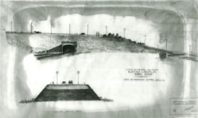
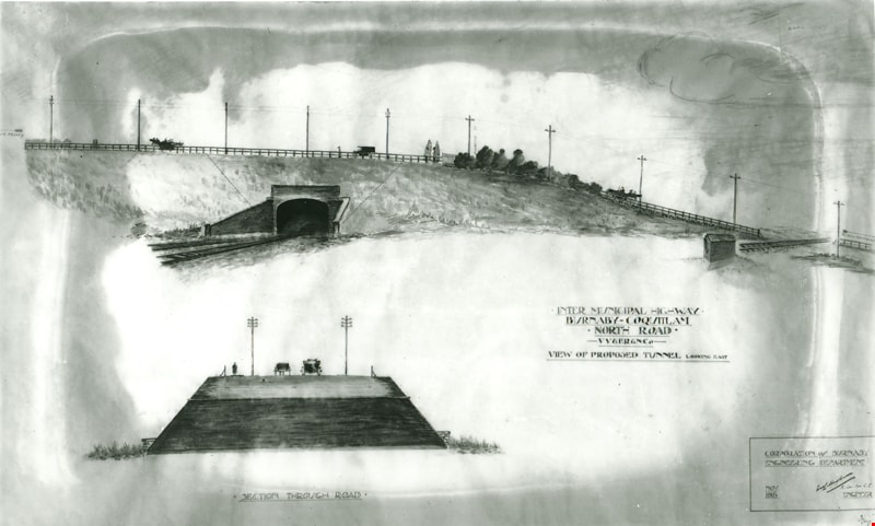
Intermunicipal Highway Burnaby-Coquitlam
https://search.heritageburnaby.ca/link/museumdescription3096
- Repository
- Burnaby Village Museum
- Date
- November 1915
- Collection/Fonds
- Burnaby Village Museum Photograph collection
- Description Level
- Item
- Physical Description
- 1 photograph : b&w glass negative ; 16.5 x 21.3 cm
- Scope and Content
- Photograph of a drawing used for a Burnaby-Coquitlam Intermunicipal Highway tunnel construction proposal. On the top of the page is a drawing of a tunnel running below the bluff on which North Road is laid. On the bottom, is a cross section drawing of the through road. Written on the corner right o…
- Repository
- Burnaby Village Museum
- Collection/Fonds
- Burnaby Village Museum Photograph collection
- Description Level
- Item
- Physical Description
- 1 photograph : b&w glass negative ; 16.5 x 21.3 cm
- Scope and Content
- Photograph of a drawing used for a Burnaby-Coquitlam Intermunicipal Highway tunnel construction proposal. On the top of the page is a drawing of a tunnel running below the bluff on which North Road is laid. On the bottom, is a cross section drawing of the through road. Written on the corner right of the drawing is "INTER MUNICIPAL HIGHWAY / BURNABY-COQUITLAM / NORTH ROAD / -VV&ER&NCo / VIEW OF PROPOSED TUNNEL LOOKING EAST", and on lower right is a box drawn around an engineer's signature, and label, "CORPORATION of BURNABY ENGINEERING DEPARTMENT / NOV. / 1915". The artist of the proposal drawing signed on the lower right corner below the engineer's signature.
- Geographic Access
- North Road
- Accession Code
- HV972.11.10
- Access Restriction
- No restrictions
- Reproduction Restriction
- No known restrictions
- Date
- November 1915
- Media Type
- Photograph
- Scan Resolution
- 300
- Scan Date
- 14/8/2006
- Scale
- 100
- Notes
- Title based on contents of photograph
- 1 b&w contact print accompanying negative
Images
![Kingsway West School, Burnaby, BC, 1917 (date of original), copied [1972] thumbnail](/media/hpo/_Data/_BVM_Images/1972/1972_0120_0001_001.jpg?width=280)
Kingsway West School, Burnaby, BC
https://search.heritageburnaby.ca/link/museumdescription1093
- Repository
- Burnaby Village Museum
- Date
- 1917 (date of original), copied [1972]
- Collection/Fonds
- Burnaby Village Museum Photograph collection
- Description Level
- Item
- Physical Description
- 1 photograph : b&w ; 25.4 x 20.3 cm print
- Scope and Content
- Photograph of the Grade 7 class at Kingsway West (originally named West Burnaby) School. Edith Crake is the teacher. The students are standing on the steps of the school.There are 20 boys and 12 girls, and Ms. Crake. Accompanying notes partially identify the students. Front row: left to right. 1) …
- Repository
- Burnaby Village Museum
- Collection/Fonds
- Burnaby Village Museum Photograph collection
- Description Level
- Item
- Physical Description
- 1 photograph : b&w ; 25.4 x 20.3 cm print
- Scope and Content
- Photograph of the Grade 7 class at Kingsway West (originally named West Burnaby) School. Edith Crake is the teacher. The students are standing on the steps of the school.There are 20 boys and 12 girls, and Ms. Crake. Accompanying notes partially identify the students. Front row: left to right. 1) Abbey, 2)&3) [unidentified], 4) Gladys Coates, 5) Ina Hart, 6) [unidentified]. Second row: left to right. 7) [unidentified], 8) [first name unknown] Murrey, 9) [first name unknown] Chapple, 10) [first name unknown] Murrey, 11)&12) [unidentified]. Third row: left to right. 13) Edith Crake (teacher), 14) Stewart MacPherson, 15) Bert Price, 16) [unidentified], 17) Gilbert Summers, 18) Alden Tayler, 19) [unidentified]. Fourth row: 20) Harold Lomas, 21) Hugh Silver, 22) [first name unknown] Murrey [?], 23) [unidentified], 24) Murray Hilton. Fifth row: 25) [unidentified], 26) Bill Logan [?], 27) [unidentified], 28) George Main. An annotation at the bottom of the original photograph reads, "Kingsway West School, Burnaby, B.C."
- Subjects
- Occupations - Teachers
- Names
- Coates, Gladys
- Crake, Edith
- Hart, Ina
- Hilton, Murray
- Kingsway West School
- Logan, Bill
- Lomas, Harold
- MacPherson, Stewart
- Main, George
- Price, Bert
- Silver, Hugh
- Summers, Gilbert
- Tayler, Alden
- Geographic Access
- Kingsway
- Street Address
- 4800 Kingsway
- Accession Code
- HV972.120.1
- Access Restriction
- No restrictions
- Reproduction Restriction
- May be restricted by third party rights
- Date
- 1917 (date of original), copied [1972]
- Media Type
- Photograph
- Historic Neighbourhood
- Central Park (Historic Neighbourhood)
- Planning Study Area
- Maywood Area
- Scan Resolution
- 600
- Scan Date
- 2023-04-18
Images
![Kingsway West School, Burnaby, BC, 1917 (date of original), copied [1972] thumbnail](/media/hpo/_Data/_BVM_Images/1972/1972_0120_0001_001.jpg)
Letter from Cotton Co. Ltd. to Burnaby regarding tender for an asphaltic paint coat
https://search.heritageburnaby.ca/link/archivedescription1706
- Repository
- City of Burnaby Archives
- Date
- 1915
- Collection/Fonds
- City Council and Office of the City Clerk fonds
- Description Level
- Item
- Physical Description
- Textual record
- Scope and Content
- Item is a letter from Cotton Co. Ltd. to Burnaby in 1915 regarding its submission of a tender for a maintainable asphaltic paint coat
- Repository
- City of Burnaby Archives
- Date
- 1915
- Collection/Fonds
- City Council and Office of the City Clerk fonds
- Physical Description
- Textual record
- Description Level
- Item
- Record No.
- 3526
- Accession Number
- 2001-02
- Scope and Content
- Item is a letter from Cotton Co. Ltd. to Burnaby in 1915 regarding its submission of a tender for a maintainable asphaltic paint coat
- Media Type
- Textual Record
![Lozells Post Office in Burnaby, [between 1910 and 1913] thumbnail](/media/hpo/_Data/_BVM_Images/1975/1975_0032_0002_001.jpg?width=280)
Lozells Post Office in Burnaby
https://search.heritageburnaby.ca/link/museumdescription898
- Repository
- Burnaby Village Museum
- Date
- [between 1910 and 1913]
- Collection/Fonds
- Burnaby Village Museum Photograph collection
- Description Level
- Item
- Physical Description
- 1 photograph : b&w ; 8.2 x 13.7 cm
- Scope and Content
- Photograph of Lozells Post Office, on the north shore of Burnaby Lake. This two storey house stood at the north eastern corner of the Great Northern tracks and Piper Road. Around the house is a low picket fence, and a large sign that read, "LOZELLS." In 1908, Col. James Ward and his wife, Mrs. War…
- Repository
- Burnaby Village Museum
- Collection/Fonds
- Burnaby Village Museum Photograph collection
- Description Level
- Item
- Physical Description
- 1 photograph : b&w ; 8.2 x 13.7 cm
- Scope and Content
- Photograph of Lozells Post Office, on the north shore of Burnaby Lake. This two storey house stood at the north eastern corner of the Great Northern tracks and Piper Road. Around the house is a low picket fence, and a large sign that read, "LOZELLS." In 1908, Col. James Ward and his wife, Mrs. Ward, came to Lozells and opened a post office. Mrs. Ward named the place Lozells because when she lived in Birmingham England, she was a parishioner in the Anglican Parish of Lozells. (Reference: George Green's "History of Burnaby" p147).
- History
- Mrs. Lozells had lived in Birmingham, England, was a parishoner in the Anglican parish of Lozells in the city. The Graeat Northern Railway laid its tracks through this district [ ] and hwne this rail route was completed the Royal City Mills built a sawmill of considerable size near the foot of Piper Avenue. C.T.W. Pyper and Alfred Wiggs built a small mill nearby and a shipping siding was installed and called Pyper's Siding. (Reference from HIstory of Burnaby by George Green.)
- Subjects
- Buildings - Public - Post Offices
- Accession Code
- HV975.32.2
- Access Restriction
- No restrictions
- Reproduction Restriction
- No known restrictions
- Date
- [between 1910 and 1913]
- Media Type
- Photograph
- Historic Neighbourhood
- Lozells (Historic Neighbourhood)
- Planning Study Area
- Government Road Area
- Scan Resolution
- 600
- Scan Date
- 2023-06-06
- Notes
- Title based on contents of photograph
Images
![Lozells Post Office in Burnaby, [between 1910 and 1913] thumbnail](/media/hpo/_Data/_BVM_Images/1975/1975_0032_0002_001.jpg)
Map of Burnaby Municipality
https://search.heritageburnaby.ca/link/museumdescription8693
- Repository
- Burnaby Village Museum
- Date
- [between 1914 and 1921]
- Collection/Fonds
- Burnaby Village Museum Map collection
- Description Level
- Item
- Physical Description
- 1 map : lithographic print, ms. annotations and hand col. on linen ; 83.5 x 57.5 cm
- Scope and Content
- Map of "BURNABY / MUNICIPALITY". "COMPILED & PUBLISHED / BY / DOMINION BLUEPRINT & MAP CO. / 576 SEYMOUR STREET / PHONE SEY. 4670 / VANCOUVER, B.C." The map also includes a handwritten title in ink above which reads: "Townplanning Maps in T.135." District lots, subdivisions, wards, blocks, schools…
- Repository
- Burnaby Village Museum
- Collection/Fonds
- Burnaby Village Museum Map collection
- Description Level
- Item
- Physical Description
- 1 map : lithographic print, ms. annotations and hand col. on linen ; 83.5 x 57.5 cm
- Material Details
- Scale [1:1666]
- Scope and Content
- Map of "BURNABY / MUNICIPALITY". "COMPILED & PUBLISHED / BY / DOMINION BLUEPRINT & MAP CO. / 576 SEYMOUR STREET / PHONE SEY. 4670 / VANCOUVER, B.C." The map also includes a handwritten title in ink above which reads: "Townplanning Maps in T.135." District lots, subdivisions, wards, blocks, schools, names, roads, railways are identified in black ink along with water ways and municipal borders. Additions have been added on top of original map print which include: red dashed lines in ink; green, blue, red lines in pencil crayon; purple, brown and red watercolour on some lots along with a bridge across the Fraser R. in red ink; pencilled Standard, Shell and Union Oil properties; pencilled numbers, arrows, natural features, notes; one line is "Gas 1930", "April 1924" next to a lot notation.
- Publisher
- Compiled and Published by Dominion Blueprint & Map Co.
- Responsibility
- Hill and Barnett Land Surveyors
- Accession Code
- BV994.34.1
- Access Restriction
- No restrictions
- Reproduction Restriction
- No known restrictions
- Date
- [between 1914 and 1921]
- Media Type
- Cartographic Material
- Notes
- Transcribed title
- Scale is measured in inches to feet
![Map of the Municipality of Burnaby, [ca.1913] thumbnail](/media/hpo/_Data/_BVM_Cartographic_Material/1988/1988_0056_0001_002%20WEB.jpg?width=280)
Map of the Municipality of Burnaby
https://search.heritageburnaby.ca/link/museumdescription14766
- Repository
- Burnaby Village Museum
- Date
- [ca.1913]
- Collection/Fonds
- Burnaby Village Museum Map collection
- Description Level
- Item
- Physical Description
- 1 map : lithographic print, b&w ; 82 x 62 cm
- Scope and Content
- Item is a map of the Municipality of Burnaby, "Published by Archibald Moir and Company, 570 Granville St., Vancouver". Map was published compliments of "Walker Brothers Real Estate Brokers and Insurance Agents", Vancouver.
- Repository
- Burnaby Village Museum
- Collection/Fonds
- Burnaby Village Museum Map collection
- Description Level
- Item
- Physical Description
- 1 map : lithographic print, b&w ; 82 x 62 cm
- Material Details
- Scale 1 inch = 1000 feet
- Scope and Content
- Item is a map of the Municipality of Burnaby, "Published by Archibald Moir and Company, 570 Granville St., Vancouver". Map was published compliments of "Walker Brothers Real Estate Brokers and Insurance Agents", Vancouver.
- Publisher
- Archibald Moir and Company
- Responsibility
- Walker Brothers Real Estate Brokers and Insurance Agents
- Accession Code
- BV988.56.1
- Access Restriction
- No restrictions
- Reproduction Restriction
- No known restrictions
- Date
- [ca.1913]
- Media Type
- Cartographic Material
- Scan Resolution
- 350
- Scan Date
- Dec. 22,2020
- Scale
- 100
- Notes
- Title based on contents of map
Zoomable Images
![Map of the Municipality of Burnaby, [ca.1913] thumbnail](/media/hpo/_Data/_BVM_Cartographic_Material/1988/1988_0056_0001_001_seadragon/1988_0056_0001_001.jpg?w=280)
![Men in Central Park, Burnaby, [1910] thumbnail](/media/hpo/_Data/_BVM_Images/1985/1985_0114_0001_001.jpg?width=280)
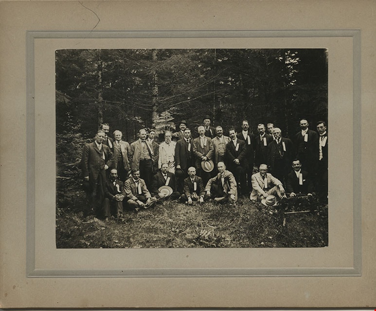
Men in Central Park, Burnaby
https://search.heritageburnaby.ca/link/museumdescription204
- Repository
- Burnaby Village Museum
- Date
- [1910]
- Collection/Fonds
- Burnaby Village Museum Photograph collection
- Description Level
- Item
- Physical Description
- 1 photograph : b&w ; 11.4 x 15.7 cm mounted on cardboard 17.8 x 22.7 cm
- Scope and Content
- Photograph of a group of twenty-five middle aged men dressed in suits, vests and hats, in Central Park in Burnaby. They all have ribbons pinned to their lapels. The information written on the ribbons is not visible. A note on file at the Burnaby Village Museum indicates that this group may have bee…
- Repository
- Burnaby Village Museum
- Collection/Fonds
- Burnaby Village Museum Photograph collection
- Description Level
- Item
- Physical Description
- 1 photograph : b&w ; 11.4 x 15.7 cm mounted on cardboard 17.8 x 22.7 cm
- Scope and Content
- Photograph of a group of twenty-five middle aged men dressed in suits, vests and hats, in Central Park in Burnaby. They all have ribbons pinned to their lapels. The information written on the ribbons is not visible. A note on file at the Burnaby Village Museum indicates that this group may have been a fraternal lodge group.
- Subjects
- Geographic Features - Parks
- Geographic Access
- Central Park
- Imperial Street
- Street Address
- 3883 Imperial Street
- Accession Code
- BV985.114.1
- Access Restriction
- No restrictions
- Reproduction Restriction
- No known restrictions
- Date
- [1910]
- Media Type
- Photograph
- Historic Neighbourhood
- Central Park (Historic Neighbourhood)
- Planning Study Area
- Maywood Area
- Scan Resolution
- 600
- Scan Date
- 2024-01-23
- Notes
- Title based on contents of photograph
Images
![Men in Central Park, Burnaby, [1910] thumbnail](/media/hpo/_Data/_BVM_Images/1985/1985_0114_0001_001.jpg)
![Men with dead fowl on board Burnaby Kid, [191-] thumbnail](/media/hpo/_Data/_BVM_Images/2022/2022_0032_0149_001.jpg?width=280)
Men with dead fowl on board Burnaby Kid
https://search.heritageburnaby.ca/link/museumdescription19727
- Repository
- Burnaby Village Museum
- Date
- [191-]
- Collection/Fonds
- Esther Love Stanley fonds
- Description Level
- Item
- Physical Description
- 1 photograph : b&w ; 8 x 11 cm
- Scope and Content
- Photograph of two men, two dogs and dead fowl on board Bob Love's boat "Burnaby Kid". Bob Love is seated at the rear of the boat and unidentified man is standing and holding a rifle. Dead fowl are hanging off the side of the boat cabin.
- Repository
- Burnaby Village Museum
- Collection/Fonds
- Esther Love Stanley fonds
- Description Level
- Item
- Physical Description
- 1 photograph : b&w ; 8 x 11 cm
- Scope and Content
- Photograph of two men, two dogs and dead fowl on board Bob Love's boat "Burnaby Kid". Bob Love is seated at the rear of the boat and unidentified man is standing and holding a rifle. Dead fowl are hanging off the side of the boat cabin.
- Accession Code
- BV022.32.149
- Access Restriction
- No restrictions
- Reproduction Restriction
- No known restrictions
- Date
- [191-]
- Media Type
- Photograph
- Scan Resolution
- 600
- Scan Date
- 2023-04-04
- Notes
- Title based on contents of photograph
- Photograph is part of Esther Love Stanley photograph album 1 (BV022.32.1)
Images
![Men with dead fowl on board Burnaby Kid, [191-] thumbnail](/media/hpo/_Data/_BVM_Images/2022/2022_0032_0149_001.jpg)
North Burnaby Auxiliary minute book
https://search.heritageburnaby.ca/link/archivedescription65050
- Repository
- City of Burnaby Archives
- Date
- 1913-1924
- Collection/Fonds
- Victorian Order of Nurses fonds
- Description Level
- Item
- Physical Description
- 1 notebook (hardcover) + 1 map
- Scope and Content
- Item is a Victorian Order of Nurses (VON) North Burnaby Auxiliary minute book. Included in the minute book is a white linen early street map depicting East Burnaby and New Westminster.
- Repository
- City of Burnaby Archives
- Date
- 1913-1924
- Collection/Fonds
- Victorian Order of Nurses fonds
- Physical Description
- 1 notebook (hardcover) + 1 map
- Description Level
- Item
- Record No.
- MSS021-004
- Accession Number
- 2010-09
- Scope and Content
- Item is a Victorian Order of Nurses (VON) North Burnaby Auxiliary minute book. Included in the minute book is a white linen early street map depicting East Burnaby and New Westminster.
- Media Type
- Textual Record
- Cartographic Material

On Curtis Road, North Burnaby
https://search.heritageburnaby.ca/link/archivedescription38854
- Repository
- City of Burnaby Archives
- Date
- 1911
- Collection/Fonds
- Peers Family and Hill Family fonds
- Description Level
- Item
- Physical Description
- 1 photograph : b&w ; 6 x 10 cm on page 14 x 17.5 cm (pasted in album)
- Scope and Content
- Photograph of Claude Hill (right) and E.B. Wentenhall (left) standing on a bridge on Curtis Road in North Burnaby. Both men are holding walking sticks.
- Repository
- City of Burnaby Archives
- Date
- 1911
- Collection/Fonds
- Peers Family and Hill Family fonds
- Physical Description
- 1 photograph : b&w ; 6 x 10 cm on page 14 x 17.5 cm (pasted in album)
- Description Level
- Item
- Record No.
- 477-173
- Access Restriction
- No restrictions
- Reproduction Restriction
- No known restrictions
- Accession Number
- 2007-12
- Scope and Content
- Photograph of Claude Hill (right) and E.B. Wentenhall (left) standing on a bridge on Curtis Road in North Burnaby. Both men are holding walking sticks.
- Subjects
- Structures - Bridges
- Media Type
- Photograph
- Notes
- Title based on caption accompanying photograph
- Geographic Access
- Curtis Street
- Historic Neighbourhood
- Lochdale (Historic Neighbourhood)
- Planning Study Area
- Lochdale Area
Images

![Royal Columbian Hospital Burnaby ward, [between 1914 and 1918] thumbnail](/media/hpo/_Data/_Archives_Images/_Unrestricted/205/209-011.jpg?width=280)
Royal Columbian Hospital Burnaby ward
https://search.heritageburnaby.ca/link/archivedescription36012
- Repository
- City of Burnaby Archives
- Date
- [between 1914 and 1918]
- Collection/Fonds
- Burnaby Historical Society fonds
- Description Level
- Item
- Physical Description
- 1 photograph : b&w ; 7 x 9.5 cm print
- Scope and Content
- Photograph of the offical opening of the Burnaby Ward at the Royal Columbian Hospital in New Westminster, BC.
- Repository
- City of Burnaby Archives
- Date
- [between 1914 and 1918]
- Collection/Fonds
- Burnaby Historical Society fonds
- Subseries
- Gavin family subseries
- Physical Description
- 1 photograph : b&w ; 7 x 9.5 cm print
- Description Level
- Item
- Record No.
- 209-011
- Access Restriction
- No restrictions
- Reproduction Restriction
- No known restrictions
- Accession Number
- BHS1988-09
- Scope and Content
- Photograph of the offical opening of the Burnaby Ward at the Royal Columbian Hospital in New Westminster, BC.
- Subjects
- Buildings - Civic - Hospitals
- Names
- Royal Columbian Hospital
- Media Type
- Photograph
- Notes
- Title based on contents of photograph
Images
![Royal Columbian Hospital Burnaby ward, [between 1914 and 1918] thumbnail](/media/hpo/_Data/_Archives_Images/_Unrestricted/205/209-011.jpg)
South Burnaby Horticultural Association minute book
https://search.heritageburnaby.ca/link/archivedescription57867
- Repository
- City of Burnaby Archives
- Date
- 1915-1929
- Collection/Fonds
- Burnaby Historical Society fonds
- Description Level
- Item
- Physical Description
- 1 notebook (hardcover)
- Scope and Content
- Item is a notebook filled with handwritten meeting minutes from the Central Park Agricultural Association and Farmer's Institute, including name change February 1927 to the South Burnaby Horticultural Association and Farmers Institute (now named the South Burnaby Garden Club).
- Repository
- City of Burnaby Archives
- Date
- 1915-1929
- Collection/Fonds
- Burnaby Historical Society fonds
- Subseries
- South Burnaby Garden Club subseries
- Physical Description
- 1 notebook (hardcover)
- Description Level
- Item
- Record No.
- MSS028-015
- Accession Number
- BHS1986-36
- Scope and Content
- Item is a notebook filled with handwritten meeting minutes from the Central Park Agricultural Association and Farmer's Institute, including name change February 1927 to the South Burnaby Horticultural Association and Farmers Institute (now named the South Burnaby Garden Club).
- Media Type
- Textual Record
- Notes
- Title based on contents of item
South Burnaby Horticultural Institute - Proposed Horticultural Hall
https://search.heritageburnaby.ca/link/archivedescription8040
- Repository
- City of Burnaby Archives
- Date
- [191-?]
- Collection/Fonds
- City Council and Office of the City Clerk fonds
- Description Level
- Item
- Physical Description
- Architectural material
- Scope and Content
- One blueprint showing the front elevation of the proposed hall.
- Repository
- City of Burnaby Archives
- Date
- [191-?]
- Collection/Fonds
- City Council and Office of the City Clerk fonds
- Physical Description
- Architectural material
- Description Level
- Item
- Record No.
- 10995
- Accession Number
- 2001-02
- Scope and Content
- One blueprint showing the front elevation of the proposed hall.
- Media Type
- Architectural Drawing
- Notes
- Located in map case.