Narrow Results By
Format
- Architectural Drawing 217
- Cartographic Material 96
- Council - Committee Report 3331
- Council - Manager's Report 6114
- Council - Mayor/Councillor/Staff Report 5691
- Council - Public Hearing Minutes 123
- Council - Regular Council Minutes 1368
- Graphic Material 14
- Moving Images 9
- Photograph
- Sound Recording
- Technical Drawing 3
Decade
- 2020s 85
- 2010s 172
- 2000s 1859
- 1990s 2556
- 1980s
- 1970s 2179
- 1960s 1187
- 1950s 1265
- 1940s 1398
- 1930s 1307
- 1920s 1725
- 1910s
- 1900s
- 1890s
- 1880s
- 1870s
- 1860s 114
- 1850s 11
- 1840s 5
- 1830s 4
- 1820s 4
- 1810s 3
- 1800s 3
- 1790s 2
- 1780s 2
- 1770s 2
- 1760s 2
- 1750s 2
- 1740s 2
- 1730s 2
- 1720s 2
- 1710s 2
- 1700s 2
- 1690s 2
- 1680s 2
- 1670s 1
- 1660s 1
- 1650s 1
- 1640s 1
- 1630s 1
- 1620s 1
- 1610s 1
- 1600s 1
- 1590s 1
- 1580s 1
- 1570s 1
- 1560s
- 1550s 1
- 1540s 1
- 1530s 1
- 1520s 1
- 1510s 1
- 1500s 1
- 1490s 1
- 1480s 1
Subject
- Advertising Medium 4
- Advertising Medium - Signs and Signboards 10
- Aerial Photographs 9
- Agricultural Tools and Equipment 7
- Agricultural Tools and Equipment - Gardening Equipment 4
- Agricultural Tools and Equipment - Plows 3
- Agriculture 2
- Agriculture - Crops 16
- Agriculture - Farms 33
- Agriculture - Fruit and Berries 15
- Agriculture - Orchards 2
- Animals 7
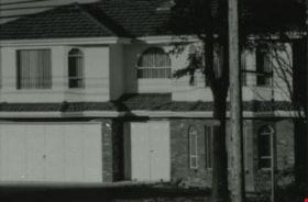
3650 Bonneville Place
https://search.heritageburnaby.ca/link/archivedescription93737
- Repository
- City of Burnaby Archives
- Date
- March 1989
- Collection/Fonds
- Grover, Elliott & Co. Ltd. fonds
- Description Level
- File
- Physical Description
- 8 photographs : col. ; 10 cm x 15 cm
- Scope and Content
- Photographs of the commercial complex located at 3650 Bonneville Place. Phase I of the complex is complete and Phase II is under construction. Businesses visible in the photographs include Four Seasons Greenhouses and Shaw.
- Repository
- City of Burnaby Archives
- Date
- March 1989
- Collection/Fonds
- Grover, Elliott & Co. Ltd. fonds
- Physical Description
- 8 photographs : col. ; 10 cm x 15 cm
- Description Level
- File
- Record No.
- 622-022
- Access Restriction
- No restrictions
- Reproduction Restriction
- No restrictions
- Accession Number
- 2017-39
- Scope and Content
- Photographs of the commercial complex located at 3650 Bonneville Place. Phase I of the complex is complete and Phase II is under construction. Businesses visible in the photographs include Four Seasons Greenhouses and Shaw.
- Subjects
- Buildings - Commercial
- Construction
- Media Type
- Photograph
- Notes
- Transcribed title
- Title transcribed from sticky note adhered to photograph 622-022-1
- File no. 89-124-B
- Photograph 622-022-1 captions reads: "3650 Bonneville - south view"
- Photograph 622-022-2 caption reads: "North and east facade"
- Photograph 622-022-3 caption reads: "View north along Broadway Street; Note entry bridges"
- Photograph 622-022-4 caption reads: "Southern view along Broadway Street"
- Photograph 622-022-5 caption reads: "Front facade and main entry for Phase I"
- Photograph 622-022-6 caption reads: "Rear and loading facilities for Phase I"
- Photograph 622-022-7 caption reads: "View west to Phase II from entry driveway"
- Photograph 622-022-8 caption reads: "Site preparation for Phase I
- Photograph captions transcribed from the paper on which the photographs were originally adhered.
- Geographic Access
- Bonneville Place
- Street Address
- 3650 Bonneville Place
- Planning Study Area
- Lake City Area
![3900 Block Union Street, [between 1912 and 1915] (date of original), copied 1991 thumbnail](/media/hpo/_Data/_Archives_Images/_Unrestricted/370/370-772.jpg?width=280)
3900 Block Union Street
https://search.heritageburnaby.ca/link/archivedescription38185
- Repository
- City of Burnaby Archives
- Date
- [between 1912 and 1915] (date of original), copied 1991
- Collection/Fonds
- Burnaby Historical Society fonds
- Description Level
- Item
- Physical Description
- 1 photograph : b&w ; 4.4 x 3.4 cm print on contact sheet 20.6 x 26.5 cm
- Scope and Content
- Photograph of the Spraggon family home and another house on the 3900 block of Union Street (formerly named Barnard Street). There is a child at play in the snow in the foreground.
- Repository
- City of Burnaby Archives
- Date
- [between 1912 and 1915] (date of original), copied 1991
- Collection/Fonds
- Burnaby Historical Society fonds
- Subseries
- Burnaby Image Bank subseries
- Physical Description
- 1 photograph : b&w ; 4.4 x 3.4 cm print on contact sheet 20.6 x 26.5 cm
- Description Level
- Item
- Record No.
- 370-772
- Access Restriction
- No restrictions
- Reproduction Restriction
- No known restrictions
- Accession Number
- BHS1999-03
- Scope and Content
- Photograph of the Spraggon family home and another house on the 3900 block of Union Street (formerly named Barnard Street). There is a child at play in the snow in the foreground.
- Media Type
- Photograph
- Notes
- Title based on contents of photograph
- 1 b&w copy negative accompanying
- Negative has a pink cast
- Geographic Access
- Union Street
- Historic Neighbourhood
- Vancouver Heights (Historic Neighbourhood)
- Planning Study Area
- Willingdon Heights Area
Images
![3900 Block Union Street, [between 1912 and 1915] (date of original), copied 1991 thumbnail](/media/hpo/_Data/_Archives_Images/_Unrestricted/370/370-772.jpg)
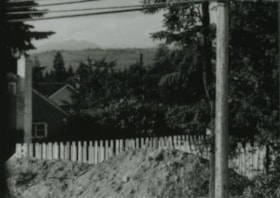
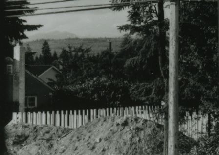
![4674 Southlawn Drive, [1989 or 1990] (date of original), copied 1991 thumbnail](/media/hpo/_Data/_Archives_Images/_Unrestricted/370/370-463.jpg?width=280)
4674 Southlawn Drive
https://search.heritageburnaby.ca/link/archivedescription37875
- Repository
- City of Burnaby Archives
- Date
- [1989 or 1990] (date of original), copied 1991
- Collection/Fonds
- Burnaby Historical Society fonds
- Description Level
- Item
- Physical Description
- 1 photograph : b&w ; 3.7 x 4.7 cm print on contact sheet 20.1 x 26.7 cm
- Scope and Content
- Photograph taken from 4674 Southlawn Drive after a snowfall, facing northwest.
- Repository
- City of Burnaby Archives
- Date
- [1989 or 1990] (date of original), copied 1991
- Collection/Fonds
- Burnaby Historical Society fonds
- Subseries
- Burnaby Image Bank subseries
- Physical Description
- 1 photograph : b&w ; 3.7 x 4.7 cm print on contact sheet 20.1 x 26.7 cm
- Description Level
- Item
- Record No.
- 370-463
- Access Restriction
- No restrictions
- Reproduction Restriction
- No restrictions
- Accession Number
- BHS1999-03
- Scope and Content
- Photograph taken from 4674 Southlawn Drive after a snowfall, facing northwest.
- Media Type
- Photograph
- Notes
- Title based on contents of photograph
- 1 b&w copy negative accompanying
- Negative has a pink cast
- Copied from col. photograph
- Geographic Access
- Southlawn Drive
- Planning Study Area
- Brentwood Area
Images
![4674 Southlawn Drive, [1989 or 1990] (date of original), copied 1991 thumbnail](/media/hpo/_Data/_Archives_Images/_Unrestricted/370/370-463.jpg)
5499-5495 Regent Street / 2857 Douglas Road
https://search.heritageburnaby.ca/link/archivedescription93713
- Repository
- City of Burnaby Archives
- Date
- 1987
- Collection/Fonds
- Grover, Elliott & Co. Ltd. fonds
- Description Level
- File
- Physical Description
- 24 photographs : col. negatives ; 35 mm
- Scope and Content
- Photographs of the building exterior and loading bays of Loomis, located at 5499 and 5495 Regent Street, and of 2857 Douglas Road. 5499 and 5495 Regent Street are addresses that no longer exist; the current address is 5491 Regent Street.
- Repository
- City of Burnaby Archives
- Date
- 1987
- Collection/Fonds
- Grover, Elliott & Co. Ltd. fonds
- Physical Description
- 24 photographs : col. negatives ; 35 mm
- Description Level
- File
- Record No.
- 622-002
- Access Restriction
- No restrictions
- Reproduction Restriction
- No restrictions
- Accession Number
- 2017-39
- Scope and Content
- Photographs of the building exterior and loading bays of Loomis, located at 5499 and 5495 Regent Street, and of 2857 Douglas Road. 5499 and 5495 Regent Street are addresses that no longer exist; the current address is 5491 Regent Street.
- Media Type
- Photograph
- Notes
- Transcribed title
- Title transcribed from original print envelope
- File no. 87-133-B
- Geographic Access
- Douglas Road
- Regent Street
- Street Address
- 2857 Douglas Road
- 5491 Regent Street
- Historic Neighbourhood
- Burnaby Lake (Historic Neighbourhood)
- Planning Study Area
- Dawson-Delta Area
5507 to 5555 Inman Ave
https://search.heritageburnaby.ca/link/archivedescription93747
- Repository
- City of Burnaby Archives
- Date
- 1989
- Collection/Fonds
- Grover, Elliott & Co. Ltd. fonds
- Description Level
- File
- Physical Description
- 19 photographs : col. negatives ; 35 mm
- Scope and Content
- Photographs of the properties located at 5507 to 5555 Inman Avenue - addresses that no longer exist. Buildings on the properties are single-storey houses.
- Repository
- City of Burnaby Archives
- Date
- 1989
- Collection/Fonds
- Grover, Elliott & Co. Ltd. fonds
- Physical Description
- 19 photographs : col. negatives ; 35 mm
- Description Level
- File
- Record No.
- 622-032
- Access Restriction
- No restrictions
- Reproduction Restriction
- No restrictions
- Accession Number
- 2017-39
- Scope and Content
- Photographs of the properties located at 5507 to 5555 Inman Avenue - addresses that no longer exist. Buildings on the properties are single-storey houses.
- Media Type
- Photograph
- Notes
- Transcribed title
- Title transcribed from print envelope photographs were originally housed in
- File no. 89-519-B
- Geographic Access
- Inman Avenue
- Historic Neighbourhood
- Central Park (Historic Neighbourhood)
- Planning Study Area
- Garden Village Area
5516-84 Barker St.
https://search.heritageburnaby.ca/link/archivedescription93740
- Repository
- City of Burnaby Archives
- Date
- 1989
- Collection/Fonds
- Grover, Elliott & Co. Ltd. fonds
- Description Level
- File
- Physical Description
- 14 photographs : col. negatives ; 35 mm
- Scope and Content
- Photographs of Barker Avenue and the properties located at 5516-5584 Barker Avenue - addresses that no longer exist. File also contains a photograph of the Sheffield Court at Central Park condominium development being constructed. Sheffield Court is located at 5635 Patterson Avenue
- Repository
- City of Burnaby Archives
- Date
- 1989
- Collection/Fonds
- Grover, Elliott & Co. Ltd. fonds
- Physical Description
- 14 photographs : col. negatives ; 35 mm
- Description Level
- File
- Record No.
- 622-025
- Access Restriction
- No restrictions
- Reproduction Restriction
- No restrictions
- Accession Number
- 2017-39
- Scope and Content
- Photographs of Barker Avenue and the properties located at 5516-5584 Barker Avenue - addresses that no longer exist. File also contains a photograph of the Sheffield Court at Central Park condominium development being constructed. Sheffield Court is located at 5635 Patterson Avenue
- Media Type
- Photograph
- Notes
- Transcribed title
- Title transcribed from print envelope photographs were originally housed in
- File no. 89-217-B
- Geographic Access
- Barker Avenue
- Patterson Avenue
- Street Address
- 5635 Patterson Avenue
- Historic Neighbourhood
- Central Park (Historic Neighbourhood)
- Planning Study Area
- Garden Village Area
5608 to 5628 Imperial Street
https://search.heritageburnaby.ca/link/archivedescription93730
- Repository
- City of Burnaby Archives
- Date
- 1989
- Collection/Fonds
- Grover, Elliott & Co. Ltd. fonds
- Description Level
- File
- Physical Description
- 16 photographs : col. negatives ; 35 mm
- Scope and Content
- Photographs of the commerical properties located between 5608 and 5628 Imperial Street and the intersection at Imperial Street and MacPherson Avenue. Businesses visible in the photographs include Galaxie Collision, Minit-tune, and Canadian Cash and Carry Tire Centre.
- Repository
- City of Burnaby Archives
- Date
- 1989
- Collection/Fonds
- Grover, Elliott & Co. Ltd. fonds
- Physical Description
- 16 photographs : col. negatives ; 35 mm
- Description Level
- File
- Record No.
- 622-018
- Access Restriction
- No restrictions
- Reproduction Restriction
- No restrictions
- Accession Number
- 2017-39
- Scope and Content
- Photographs of the commerical properties located between 5608 and 5628 Imperial Street and the intersection at Imperial Street and MacPherson Avenue. Businesses visible in the photographs include Galaxie Collision, Minit-tune, and Canadian Cash and Carry Tire Centre.
- Media Type
- Photograph
- Photographer
- Young, J.
- Notes
- Transcribed title
- Title transcribed from original print envelope
- Geographic Access
- Imperial Street
- MacPherson Avenue
- Street Address
- 5608 Imperial Street
- 5628 Imperial Street
- Historic Neighbourhood
- Central Park (Historic Neighbourhood)
- Planning Study Area
- Windsor Area
5621 Imperial Street
https://search.heritageburnaby.ca/link/archivedescription93712
- Repository
- City of Burnaby Archives
- Date
- 1987
- Collection/Fonds
- Grover, Elliott & Co. Ltd. fonds
- Description Level
- File
- Physical Description
- 8 photographs : col. ; 10 cm x 15 cm
- Scope and Content
- Photographs of the exterior of the commerical property located at 5621 Imperial Street.
- Repository
- City of Burnaby Archives
- Date
- 1987
- Collection/Fonds
- Grover, Elliott & Co. Ltd. fonds
- Physical Description
- 8 photographs : col. ; 10 cm x 15 cm
- Description Level
- File
- Record No.
- 622-001
- Access Restriction
- No restrictions
- Reproduction Restriction
- No restrictions
- Accession Number
- 2017-39
- Scope and Content
- Photographs of the exterior of the commerical property located at 5621 Imperial Street.
- Subjects
- Buildings - Commercial
- Media Type
- Photograph
- Notes
- Transcribed title
- Title transcribed from original print envelope
- File no. 87-056-B
- Geographic Access
- Imperial Street
- Street Address
- 5621 Imperial Street
- Historic Neighbourhood
- Central Park (Historic Neighbourhood)
- Planning Study Area
- Windsor Area
5707 Sidley Street
https://search.heritageburnaby.ca/link/archivedescription93726
- Repository
- City of Burnaby Archives
- Date
- 1989
- Collection/Fonds
- Grover, Elliott & Co. Ltd. fonds
- Description Level
- File
- Physical Description
- 16 photographs : col. negatives ; 35 mm
- Scope and Content
- Photographs of the exterior of an industrial development located at 5707 Sidley Street.
- Repository
- City of Burnaby Archives
- Date
- 1989
- Collection/Fonds
- Grover, Elliott & Co. Ltd. fonds
- Physical Description
- 16 photographs : col. negatives ; 35 mm
- Description Level
- File
- Record No.
- 622-014
- Access Restriction
- No restrictions
- Reproduction Restriction
- No restrictions
- Accession Number
- 2017-39
- Scope and Content
- Photographs of the exterior of an industrial development located at 5707 Sidley Street.
- Subjects
- Buildings - Industrial
- Media Type
- Photograph
- Notes
- Transcribed title
- Title transcribed from note on verso of photograph
- Geographic Access
- Sidley Street
- Street Address
- 5707 Sidley Street
- Historic Neighbourhood
- Alta Vista (Historic Neighbourhood)
- Planning Study Area
- Clinton-Glenwood Area
6088 Cassie Avenue
https://search.heritageburnaby.ca/link/archivedescription93717
- Repository
- City of Burnaby Archives
- Date
- 1987
- Collection/Fonds
- Grover, Elliott & Co. Ltd. fonds
- Description Level
- File
- Physical Description
- 14 photographs : col. negatives ; 35 mm + 5 photographs : col. ; 10 cm x 15 cm
- Scope and Content
- Photographs of the private residence and garden located at 6088 Cassie Avenue - an address that no longer exists.
- Repository
- City of Burnaby Archives
- Date
- 1987
- Collection/Fonds
- Grover, Elliott & Co. Ltd. fonds
- Physical Description
- 14 photographs : col. negatives ; 35 mm + 5 photographs : col. ; 10 cm x 15 cm
- Description Level
- File
- Record No.
- 622-006
- Access Restriction
- No restrictions
- Reproduction Restriction
- No restrictions
- Accession Number
- 2017-39
- Scope and Content
- Photographs of the private residence and garden located at 6088 Cassie Avenue - an address that no longer exists.
- Media Type
- Photograph
- Notes
- Transcribed title
- Title transcribed from original print envelope
- File no. 87-300-B
- Geographic Access
- Cassie Avenue
- Historic Neighbourhood
- Central Park (Historic Neighbourhood)
- Planning Study Area
- Maywood Area

6113 Silver Avenue lot
https://search.heritageburnaby.ca/link/archivedescription37775
- Repository
- City of Burnaby Archives
- Date
- 1986 (date of original), copied 1991
- Collection/Fonds
- Burnaby Historical Society fonds
- Description Level
- Item
- Physical Description
- 1 photograph : b&w ; 3.1 x 4.4 cm print on contact sheet 20.3 x 26.2 cm
- Scope and Content
- Photograph of the lot at 6113 Silver Avenue, the former home of the Ellis family. The house has been demolished and an empty lot remains. Houses, aparment buildings, and the Expo line skytrain track with cars on it can be seen in the background.
- Repository
- City of Burnaby Archives
- Date
- 1986 (date of original), copied 1991
- Collection/Fonds
- Burnaby Historical Society fonds
- Subseries
- Burnaby Image Bank subseries
- Physical Description
- 1 photograph : b&w ; 3.1 x 4.4 cm print on contact sheet 20.3 x 26.2 cm
- Description Level
- Item
- Record No.
- 370-363
- Access Restriction
- No restrictions
- Reproduction Restriction
- No restrictions
- Accession Number
- BHS1999-03
- Scope and Content
- Photograph of the lot at 6113 Silver Avenue, the former home of the Ellis family. The house has been demolished and an empty lot remains. Houses, aparment buildings, and the Expo line skytrain track with cars on it can be seen in the background.
- Subjects
- Land Clearing
- Media Type
- Photograph
- Notes
- Title based on contents of photograph
- 1 b&w copy negative accompanying
- Negative has a pink cast
- Copied from col. photograph
- Geographic Access
- Silver Avenue
- Street Address
- 6113 Silver Avenue
- Historic Neighbourhood
- Central Park (Historic Neighbourhood)
- Planning Study Area
- Maywood Area
Images

6622 Willingdon
https://search.heritageburnaby.ca/link/archivedescription93741
- Repository
- City of Burnaby Archives
- Date
- 1989
- Collection/Fonds
- Grover, Elliott & Co. Ltd. fonds
- Description Level
- File
- Physical Description
- 14 photographs : col. negatives ; 35 mm + 3 photographs : col. ; 10 cm x 15 cm
- Scope and Content
- Photographs of the exterior of a three-storey apartment complex located at 6622 Willingdon Avenue, an unidentified industrial complex (Norland), and Heywood Park Place.
- Repository
- City of Burnaby Archives
- Date
- 1989
- Collection/Fonds
- Grover, Elliott & Co. Ltd. fonds
- Physical Description
- 14 photographs : col. negatives ; 35 mm + 3 photographs : col. ; 10 cm x 15 cm
- Description Level
- File
- Record No.
- 622-026
- Access Restriction
- No restrictions
- Reproduction Restriction
- No restrictions
- Accession Number
- 2017-39
- Scope and Content
- Photographs of the exterior of a three-storey apartment complex located at 6622 Willingdon Avenue, an unidentified industrial complex (Norland), and Heywood Park Place.
- Media Type
- Photograph
- Notes
- Transcribed title
- Title transcribed from print envelope photographs were originally housed in
- File no. 89-235-B
- Photographs 622-026-15 : 622-026-17 depict 6622 Willingdon Avenue
- Geographic Access
- Willingdon Avenue
- Street Address
- 6622 Willingdon Avenue
- Historic Neighbourhood
- Central Park (Historic Neighbourhood)
- Planning Study Area
- Maywood Area

6742 Walker Avenue
https://search.heritageburnaby.ca/link/archivedescription37844
- Repository
- City of Burnaby Archives
- Date
- May 1987 (date of original), copied 1991
- Collection/Fonds
- Burnaby Historical Society fonds
- Description Level
- Item
- Physical Description
- 1 photograph : b&w ; 3.1 x 4.3 cm print on contact sheet 20.6 x 26.7 cm
- Scope and Content
- Photograph of 6742 Walker Avenue, with only the trees in the yard visible from the road. A van is parked in front.
- Repository
- City of Burnaby Archives
- Date
- May 1987 (date of original), copied 1991
- Collection/Fonds
- Burnaby Historical Society fonds
- Subseries
- Burnaby Image Bank subseries
- Physical Description
- 1 photograph : b&w ; 3.1 x 4.3 cm print on contact sheet 20.6 x 26.7 cm
- Description Level
- Item
- Record No.
- 370-432
- Access Restriction
- No restrictions
- Reproduction Restriction
- No restrictions
- Accession Number
- BHS1999-03
- Scope and Content
- Photograph of 6742 Walker Avenue, with only the trees in the yard visible from the road. A van is parked in front.
- Subjects
- Plants - Trees
- Media Type
- Photograph
- Notes
- Title based on contents of photograph
- 1 b&w copy negative accompanying
- Negative has a pink cast
- Copied from col. photograph
- Geographic Access
- Walker Avenue
- Street Address
- 6742 Walker Avenue
- Historic Neighbourhood
- Edmonds (Historic Neighbourhood)
- Planning Study Area
- Richmond Park Area
Images


6742 Walker Avenue
https://search.heritageburnaby.ca/link/archivedescription37845
- Repository
- City of Burnaby Archives
- Date
- May 1987 (date of original), copied 1991
- Collection/Fonds
- Burnaby Historical Society fonds
- Description Level
- Item
- Physical Description
- 1 photograph : b&w ; 3.0 x 4.4 cm print on contact sheet 20.6 x 26.7 cm
- Scope and Content
- Photograph of 6742 Walker Avenue with some of the trees in the yard cut down.
- Repository
- City of Burnaby Archives
- Date
- May 1987 (date of original), copied 1991
- Collection/Fonds
- Burnaby Historical Society fonds
- Subseries
- Burnaby Image Bank subseries
- Physical Description
- 1 photograph : b&w ; 3.0 x 4.4 cm print on contact sheet 20.6 x 26.7 cm
- Description Level
- Item
- Record No.
- 370-433
- Access Restriction
- No restrictions
- Reproduction Restriction
- No restrictions
- Accession Number
- BHS1999-03
- Scope and Content
- Photograph of 6742 Walker Avenue with some of the trees in the yard cut down.
- Subjects
- Plants - Trees
- Media Type
- Photograph
- Notes
- Title based on contents of photograph
- 1 b&w copy negative accompanying
- Negative has a pink cast
- Copied from col. photograph
- Geographic Access
- Walker Avenue
- Street Address
- 6742 Walker Avenue
- Historic Neighbourhood
- Edmonds (Historic Neighbourhood)
- Planning Study Area
- Richmond Park Area
Images


6742 Walker Avenue
https://search.heritageburnaby.ca/link/archivedescription37846
- Repository
- City of Burnaby Archives
- Date
- May 1987 (date of original), copied 1991
- Collection/Fonds
- Burnaby Historical Society fonds
- Description Level
- Item
- Physical Description
- 1 photograph : b&w ; 3.0 x 4.3 cm print on contact sheet 20.6 x 26.7 cm
- Scope and Content
- Photograph of 6742 Walker Avenue, showing the stumps of the recently cut down trees in the yard of the house.
- Repository
- City of Burnaby Archives
- Date
- May 1987 (date of original), copied 1991
- Collection/Fonds
- Burnaby Historical Society fonds
- Subseries
- Burnaby Image Bank subseries
- Physical Description
- 1 photograph : b&w ; 3.0 x 4.3 cm print on contact sheet 20.6 x 26.7 cm
- Description Level
- Item
- Record No.
- 370-434
- Access Restriction
- No restrictions
- Reproduction Restriction
- No restrictions
- Accession Number
- BHS1999-03
- Scope and Content
- Photograph of 6742 Walker Avenue, showing the stumps of the recently cut down trees in the yard of the house.
- Media Type
- Photograph
- Notes
- Title based on contents of photograph
- 1 b&w copy negative accompanying
- Negative has a pink cast
- Copied from col. photograph
- Geographic Access
- Walker Avenue
- Street Address
- 6742 Walker Avenue
- Historic Neighbourhood
- Edmonds (Historic Neighbourhood)
- Planning Study Area
- Richmond Park Area
Images

6742 Walker Avenue
https://search.heritageburnaby.ca/link/archivedescription37853
- Repository
- City of Burnaby Archives
- Date
- June 1987 (date of original), copied 1991
- Collection/Fonds
- Burnaby Historical Society fonds
- Description Level
- Item
- Physical Description
- 1 photograph : b&w ; 3.0 x 4.3 cm print on contact sheet 20.6 x 26.7 cm
- Scope and Content
- Photograph of the foundation of a house at 6742 Walker Avenue.
- Repository
- City of Burnaby Archives
- Date
- June 1987 (date of original), copied 1991
- Collection/Fonds
- Burnaby Historical Society fonds
- Subseries
- Burnaby Image Bank subseries
- Physical Description
- 1 photograph : b&w ; 3.0 x 4.3 cm print on contact sheet 20.6 x 26.7 cm
- Description Level
- Item
- Record No.
- 370-441
- Access Restriction
- No restrictions
- Reproduction Restriction
- No restrictions
- Accession Number
- BHS1999-03
- Scope and Content
- Photograph of the foundation of a house at 6742 Walker Avenue.
- Media Type
- Photograph
- Notes
- Title based on contents of photograph
- 1 b&w copy negative accompanying
- Negative has a pink cast
- Copied from col. photograph
- Geographic Access
- Walker Avenue
- Street Address
- 6742 Walker Avenue
- Historic Neighbourhood
- Edmonds (Historic Neighbourhood)
- Planning Study Area
- Richmond Park Area
Images
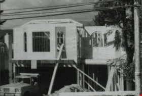
6742 Walker Avenue
https://search.heritageburnaby.ca/link/archivedescription37863
- Repository
- City of Burnaby Archives
- Date
- 1987 (date of original), copied 1991
- Collection/Fonds
- Burnaby Historical Society fonds
- Description Level
- Item
- Physical Description
- 1 photograph : b&w ; 3.1 x 4.6 cm print on contact sheet 20.4 x 26.7 cm
- Scope and Content
- Photograph of the completed construction of a house at 6742 Walker Avenue, summer 1987.
- Repository
- City of Burnaby Archives
- Date
- 1987 (date of original), copied 1991
- Collection/Fonds
- Burnaby Historical Society fonds
- Subseries
- Burnaby Image Bank subseries
- Physical Description
- 1 photograph : b&w ; 3.1 x 4.6 cm print on contact sheet 20.4 x 26.7 cm
- Description Level
- Item
- Record No.
- 370-451
- Access Restriction
- No restrictions
- Reproduction Restriction
- No restrictions
- Accession Number
- BHS1999-03
- Scope and Content
- Photograph of the completed construction of a house at 6742 Walker Avenue, summer 1987.
- Subjects
- Buildings - Residential - Houses
- Media Type
- Photograph
- Notes
- Title based on contents of photograph
- 1 b&w copy negative accompanying
- Negative has a pink cast
- Copied from col. photograph
- Geographic Access
- Walker Avenue
- Street Address
- 6742 Walker Avenue
- Historic Neighbourhood
- Edmonds (Historic Neighbourhood)
- Planning Study Area
- Richmond Park Area
Images

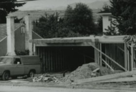
6742 Walker Avenue construction
https://search.heritageburnaby.ca/link/archivedescription37854
- Repository
- City of Burnaby Archives
- Date
- June 1987 (date of original), copied 1991
- Collection/Fonds
- Burnaby Historical Society fonds
- Description Level
- Item
- Physical Description
- 1 photograph : b&w ; 3.0 x 4.3 cm print on contact sheet 20.6 x 26.7 cm
- Scope and Content
- Photograph of the garage and ground floor frame of a house at 6742 Walker Avenue, mid to late June, 1987. A truck is parked in front.
- Repository
- City of Burnaby Archives
- Date
- June 1987 (date of original), copied 1991
- Collection/Fonds
- Burnaby Historical Society fonds
- Subseries
- Burnaby Image Bank subseries
- Physical Description
- 1 photograph : b&w ; 3.0 x 4.3 cm print on contact sheet 20.6 x 26.7 cm
- Description Level
- Item
- Record No.
- 370-442
- Access Restriction
- No restrictions
- Reproduction Restriction
- No restrictions
- Accession Number
- BHS1999-03
- Scope and Content
- Photograph of the garage and ground floor frame of a house at 6742 Walker Avenue, mid to late June, 1987. A truck is parked in front.
- Subjects
- Construction
- Media Type
- Photograph
- Notes
- Title based on contents of photograph
- 1 b&w copy negative accompanying
- Negative has a pink cast
- Copied from col. photograph
- Geographic Access
- Walker Avenue
- Street Address
- 6742 Walker Avenue
- Historic Neighbourhood
- Edmonds (Historic Neighbourhood)
- Planning Study Area
- Richmond Park Area
Images

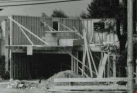
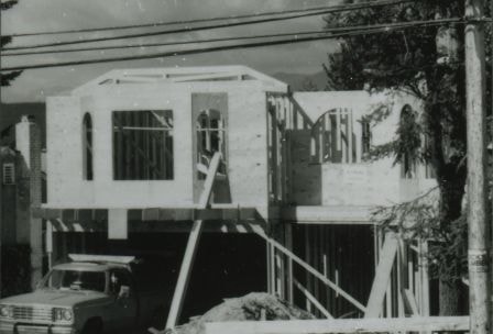
6742 Walker Avenue construction
https://search.heritageburnaby.ca/link/archivedescription37855
- Repository
- City of Burnaby Archives
- Date
- June 1987 (date of original), copied 1991
- Collection/Fonds
- Burnaby Historical Society fonds
- Description Level
- Item
- Physical Description
- 1 photograph : b&w ; 3.0 x 4.4 cm print on contact sheet 20.6 x 26.7 cm
- Scope and Content
- Photograph of the construction of a house at 6742 Walker Avenue.
- Repository
- City of Burnaby Archives
- Date
- June 1987 (date of original), copied 1991
- Collection/Fonds
- Burnaby Historical Society fonds
- Subseries
- Burnaby Image Bank subseries
- Physical Description
- 1 photograph : b&w ; 3.0 x 4.4 cm print on contact sheet 20.6 x 26.7 cm
- Description Level
- Item
- Record No.
- 370-443
- Access Restriction
- No restrictions
- Reproduction Restriction
- No restrictions
- Accession Number
- BHS1999-03
- Scope and Content
- Photograph of the construction of a house at 6742 Walker Avenue.
- Media Type
- Photograph
- Notes
- Title based on contents of photograph
- 1 b&w copy negative accompanying
- Negative has a pink cast
- Copied from col. photograph
- Geographic Access
- Walker Avenue
- Street Address
- 6742 Walker Avenue
- Historic Neighbourhood
- Edmonds (Historic Neighbourhood)
- Planning Study Area
- Richmond Park Area
Images
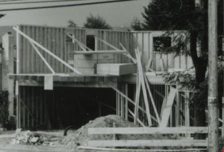
6742 Walker Avenue construction
https://search.heritageburnaby.ca/link/archivedescription37856
- Repository
- City of Burnaby Archives
- Date
- June 1987 (date of original), copied 1991
- Collection/Fonds
- Burnaby Historical Society fonds
- Description Level
- Item
- Physical Description
- 1 photograph : b&w ; 3.1 x 4.4 cm print on contact sheet 20.4 x 26.7 cm
- Scope and Content
- Photograph of the construction of a house at 6742 Walker Avenue.
- Repository
- City of Burnaby Archives
- Date
- June 1987 (date of original), copied 1991
- Collection/Fonds
- Burnaby Historical Society fonds
- Subseries
- Burnaby Image Bank subseries
- Physical Description
- 1 photograph : b&w ; 3.1 x 4.4 cm print on contact sheet 20.4 x 26.7 cm
- Description Level
- Item
- Record No.
- 370-444
- Access Restriction
- No restrictions
- Reproduction Restriction
- No restrictions
- Accession Number
- BHS1999-03
- Scope and Content
- Photograph of the construction of a house at 6742 Walker Avenue.
- Media Type
- Photograph
- Notes
- Title based on contents of photograph
- 1 b&w copy negative accompanying
- Negative has a pink cast
- Copied from col. photograph
- Geographic Access
- Walker Avenue
- Street Address
- 6742 Walker Avenue
- Historic Neighbourhood
- Edmonds (Historic Neighbourhood)
- Planning Study Area
- Richmond Park Area
Images