More like 'Sign'
Narrow Results By
Subject
- Academic Disciplines 1
- Accidents - Train Accidents 1
- Advertising Medium 5
- Advertising Medium - Signs and Signboards 11
- Agricultural Tools and Equipment 1
- Agricultural Tools and Equipment - Plows 3
- Agriculture - Crops 5
- Agriculture - Farms 4
- Animals - Dogs 7
- Animals - Horses 6
- Armament - Munitions 2
- Arts - Paintings 1
Creator
- Alymer-Small, Sidney 1
- Barrowclough, G.A. 1
- Blackwood, Paul E., 1913-1997 1
- Board of Transport Commissioners for Canada 2
- Burnaby Village Museum 2
- Canada. Department of Mines and Technical Surveys. Geographical Branch 1
- Canadian National Railways 1
- Canadian Pacific Railway Company 2
- City of Burnaby 1
- City of Winnipeg 1
- Cooksley, William Thomas 1
- Damer, Eric 1

Arrow Neon Sign
https://search.heritageburnaby.ca/link/landmark861
- Repository
- Burnaby Heritage Planning
- Description
- Commercial building.
- Associated Dates
- 1961
- Other Names
- Lost in the 50's Drive-in
- Street View URL
- Google Maps Street View
- Repository
- Burnaby Heritage Planning
- Other Names
- Lost in the 50's Drive-in
- Geographic Access
- Edmonds Street
- Associated Dates
- 1961
- Description
- Commercial building.
- Heritage Value
- The Arrow Neon Sign was built in 1961 by the Neonette Sign Company of New Westminster when this property was opened as the Tomahawk Drive-in Restaurant. The restaurant was later known as Lindy's Burger and in 1990, the business was renamed Lost in the 50's Drive-in. It stands 20-foot tall and is composed of a large double-sided hollow steel panel serpentine arrow mounted on a pole supporting a lexan sign panel measuring approximately 8 feet wide by 4 feet tall. The sign was designed with three illuminated features: a round lamp at the top of the pole, a double-sided rectangular fluorescent sign panel box, and two double-sided rows of orange neon arrows that follow the large serpentine arrow. The Arrow Neon Sign remains as a rare surviving example of neon sign art in the city and is the only historic neon sign in South Burnaby. The sign has gained prominence over the years as it has been associated with this small iconic drive-in which has also been utilized as a set for film production. Additionally, the drive-in has played a prominent role in the Edmonds community as a popular setting for recent "Show and Shine" participants to park their classic cars.
- Locality
- Edmonds
- Historic Neighbourhood
- East Burnaby (Historic Neighbourhood)
- Planning Study Area
- Lakeview-Mayfield Area
- Builder
- Neonette Sign Company
- Community
- Burnaby
- Contributing Resource
- Structure
- Ownership
- Public (local)
- Street Address
- 7741 Edmonds Street
- Street View URL
- Google Maps Street View
Images


Duncan & Margaret McGregor Estate 'Glen-Lyon' Mansion
https://search.heritageburnaby.ca/link/landmark518
- Repository
- Burnaby Heritage Planning
- Description
- Overlooking the rich farmland of the Fraser River floodplain, 'Glen-Lyon' is an Edwardian era rural estate, with a tall, two and one-half storey plus basement wood-frame mansion, set in a pastoral and formal landscape with an associated barn and early log pond, located near a ravine and forested ar…
- Associated Dates
- 1902
- Formal Recognition
- Heritage Designation, Community Heritage Register
- Street View URL
- Google Maps Street View
- Repository
- Burnaby Heritage Planning
- Geographic Access
- Marine Drive
- Associated Dates
- 1902
- Formal Recognition
- Heritage Designation, Community Heritage Register
- Enactment Type
- Bylaw No. 12183
- Enactment Date
- 11/12/2006
- Description
- Overlooking the rich farmland of the Fraser River floodplain, 'Glen-Lyon' is an Edwardian era rural estate, with a tall, two and one-half storey plus basement wood-frame mansion, set in a pastoral and formal landscape with an associated barn and early log pond, located near a ravine and forested area adjacent to Marine Drive in South Burnaby.
- Heritage Value
- ‘Glen-Lyon’ is valued as an excellent example of a privately-owned Edwardian era country estate built at the turn of the nineteenth century. The property retains significant heritage features including the Edwardian era mansion with rustic Arts and Crafts features, and elements of a working agricultural landscape. The property was originally the Royal City Mills logging camp, and in 1900 was purchased by Duncan Campbell McGregor (1853-1929) and Margaret Jane McGregor (1875-1960), who named their estate ‘Glen-Lyon’ after Duncan McGregor’s birthplace in Perthshire, Scotland. The McGregors were active in municipal affairs and social activities, and played a significant role in the early development of Burnaby. Duncan McGregor served as a city councillor from 1909 to 1912 and was elected reeve of Burnaby in 1913. Margaret McGregor was instrumental in the formation and fundraising activities of the Victoria Order of Nurses in Burnaby. Additionally, the site is historically significant for its association with early social welfare and correctional reform. The estate was sold in 1926 to an inter-denominational religious organization called the Home of the Friendless, which used it as their B.C. headquarters. The organization was charged with several cases of abuse and neglect in 1937, after which a Royal Commission was formed that led to new legislation to regulate and license all private welfare institutions. 'Glen-Lyon' was sold to the provincial government, and was dedicated in 1939 by the Lt.-Gov. E.W. Hamber for use as the New Haven Borstal Home for Boys and Youthful Offenders (later renamed the New Haven Correction Centre). The Borstal movement originated in England in the late nineteenth century, as an alternative to sending young offenders and runaways to prisons by providing reformatories that focused on discipline and vocational skill. This site’s role as the first North American institution devoted to the Borstal School philosophy was historic, and influenced corrections programs across Canada. The site retains significant features from its development in 1939 as the Borstal School, including a large gambrel-roofed barn designed by Chief Provincial Architect Henry Whittaker of the Department of Public Works that is the only remaining structure of its kind in Burnaby. Between 1941 and 1945 the mansion housed the Provincial School for the Deaf and Blind when the Borstal School was closed temporarily as a war measure during the Second World War.
- Defining Elements
- Key elements that define the heritage character of 'Glen-Lyon' Mansion include its: - location on a sloping site with expansive southern exposure, adjacent to Marine Drive - residential form, scale and massing of the house as exemplified by its two and one-half storey height, above-ground basement and rectangular plan - Arts and Crafts elements of the house such as its stone foundation, multi-gabled roof line with steep central hipped roof, symmetrical cross-gables, side shed dormers, bellcast upper walls sheathed in cedar shingles and lower walls sheathed in narrow clapboard - original exterior features of the house such as the full width front verandah with square columns, central staircase on the southern elevation, original doors and stained glass windows; and the irregular fenestration such as double-hung 1-over-1 wooden-sash windows, bay windows, and projecting windows in the gable ends - original interior features of the house such as the U-shaped main stair designed around two symmetrically placed Ionic columns, and interior trim on the main floor including boxed beams and fireplaces - gambrel-roofed barn with roof vent with finial, sliding hay loft and access doors, small multi-pane windows, and lapped wooden siding - associated landscape features such as the original garden plantings with some exotic and many native specimen trees; the original log pond and its concrete Marine Drive causeway and culvert; rockeries and a rose garden
- Historic Neighbourhood
- Fraser Arm (Historic Neighbourhood)
- Planning Study Area
- Big Bend Area
- Architect
- Henry Whittaker
- Function
- Primary Historic--Estate
- Community
- Burnaby
- Cadastral Identifier
- 003-004-661
- Boundaries
- 'Glen-Lyon' is comprised of a single residential lot located at 4250 Marine Drive, Burnaby.
- Area
- 230873.18
- Contributing Resource
- Building
- Ownership
- Private
- Names
- McGregor, Duncan C. (1853-1929)
- Whittaker, Henry
- Home of the Friendless
- Borstal School
- New Haven Correction Centre
- Subjects
- Buildings - Heritage
- Buildings - Residential - Houses
- Buildings - Public - Detention Facilities
- Buildings - Residential
- Street Address
- 4250 Marine Drive
- Street View URL
- Google Maps Street View
Images


![Interurban tram 1223 at the Edmonds Bus Loop, April 24, 1966 (date of original), copied [199-?] thumbnail](/media/hpo/_Data/_Archives_Images/_Unrestricted/001/066-009.jpg?width=280)
Interurban tram 1223 at the Edmonds Bus Loop
https://search.heritageburnaby.ca/link/archivedescription34605
- Repository
- City of Burnaby Archives
- Date
- April 24, 1966 (date of original), copied [199-?]
- Collection/Fonds
- Burnaby Historical Society fonds
- Description Level
- Item
- Physical Description
- 1 photograph : b&w negative ; 6.1 x 6.3 cm
- Scope and Content
- Photograph of the Interurban tram no. 1223 restoration at the Edmonds bus loop at Edmonds Street and Kingsway. Men on a scaffold are working on the tram, and two buses are visible.
- Repository
- City of Burnaby Archives
- Date
- April 24, 1966 (date of original), copied [199-?]
- Collection/Fonds
- Burnaby Historical Society fonds
- Subseries
- Photographs subseries
- Physical Description
- 1 photograph : b&w negative ; 6.1 x 6.3 cm
- Description Level
- Item
- Record No.
- 066-009
- Access Restriction
- No restrictions
- Reproduction Restriction
- Reproduce for fair dealing purposes only
- Accession Number
- BHS2007-04
- Scope and Content
- Photograph of the Interurban tram no. 1223 restoration at the Edmonds bus loop at Edmonds Street and Kingsway. Men on a scaffold are working on the tram, and two buses are visible.
- Media Type
- Photograph
- Notes
- Title based on contents of photograph
- 1 b&w copy print accompanying
- Geographic Access
- Kingsway
- Edmonds Street
- Historic Neighbourhood
- Edmonds (Historic Neighbourhood)
- Planning Study Area
- Stride Avenue Area
Images
![Interurban tram 1223 at the Edmonds Bus Loop, April 24, 1966 (date of original), copied [199-?] thumbnail](/media/hpo/_Data/_Archives_Images/_Unrestricted/001/066-009.jpg)
![Interurban tram 1223 at the Edmonds Bus Loop, [April 24, 1966] (date of original), copied [199-] thumbnail](/media/hpo/_Data/_Archives_Images/_Unrestricted/001/066-011.jpg?width=280)
Interurban tram 1223 at the Edmonds Bus Loop
https://search.heritageburnaby.ca/link/archivedescription34607
- Repository
- City of Burnaby Archives
- Date
- [April 24, 1966] (date of original), copied [199-]
- Collection/Fonds
- Burnaby Historical Society fonds
- Description Level
- Item
- Physical Description
- 1 photograph : b&w negative ; 6.4 x 6.1 cm
- Scope and Content
- Photograph of Interurban tram no. 1223 on display at the Edmonds Bus Loop at Edmonds Street and Kingsway.
- Repository
- City of Burnaby Archives
- Date
- [April 24, 1966] (date of original), copied [199-]
- Collection/Fonds
- Burnaby Historical Society fonds
- Subseries
- Photographs subseries
- Physical Description
- 1 photograph : b&w negative ; 6.4 x 6.1 cm
- Description Level
- Item
- Record No.
- 066-011
- Access Restriction
- No restrictions
- Reproduction Restriction
- Reproduce for fair dealing purposes only
- Accession Number
- BHS2007-04
- Scope and Content
- Photograph of Interurban tram no. 1223 on display at the Edmonds Bus Loop at Edmonds Street and Kingsway.
- Media Type
- Photograph
- Notes
- Title based on contents of photograph
- 1 b&w copy print accompanying
- Geographic Access
- Kingsway
- Edmonds Street
- Historic Neighbourhood
- Edmonds (Historic Neighbourhood)
- Planning Study Area
- Stride Avenue Area
Images
![Interurban tram 1223 at the Edmonds Bus Loop, [April 24, 1966] (date of original), copied [199-] thumbnail](/media/hpo/_Data/_Archives_Images/_Unrestricted/001/066-011.jpg)
![Tram 1223, [195-] (date of original), copied 1992 thumbnail](/media/hpo/_Data/_Archives_Images/_Unrestricted/315/315-507.jpg?width=280)
Tram 1223
https://search.heritageburnaby.ca/link/archivedescription37044
- Repository
- City of Burnaby Archives
- Date
- [195-] (date of original), copied 1992
- Collection/Fonds
- Burnaby Historical Society fonds
- Description Level
- Item
- Physical Description
- 1 photograph : b&w ; 8.1 x 12.0 cm print
- Scope and Content
- Photograph of Central Park Interurban line, tram no. 1223.
- Repository
- City of Burnaby Archives
- Date
- [195-] (date of original), copied 1992
- Collection/Fonds
- Burnaby Historical Society fonds
- Subseries
- Burnaby Centennial Anthology subseries
- Physical Description
- 1 photograph : b&w ; 8.1 x 12.0 cm print
- Description Level
- Item
- Record No.
- 315-507
- Access Restriction
- No restrictions
- Reproduction Restriction
- Reproduce for fair dealing purposes only
- Accession Number
- BHS1994-04
- Scope and Content
- Photograph of Central Park Interurban line, tram no. 1223.
- Media Type
- Photograph
- Notes
- Title based on contents of photograph
- Geographic Access
- Central Park Interurban line
Images
![Tram 1223, [195-] (date of original), copied 1992 thumbnail](/media/hpo/_Data/_Archives_Images/_Unrestricted/315/315-507.jpg)

Tram 1223 at the Edmonds Bus Loop
https://search.heritageburnaby.ca/link/archivedescription34599
- Repository
- City of Burnaby Archives
- Date
- July 15, 1966
- Collection/Fonds
- Burnaby Historical Society fonds
- Description Level
- Item
- Physical Description
- 1 photograph : b&w ; negative ; 4.6 x 4.6 cm
- Scope and Content
- Photograph of the Edmonds Bus Loop at Edmonds Street and Kingsway with Interurban tram no. 1223 (Central Park Line) on display under a covered area to the left. The side of a bus visible on the right. There is a bus stop sign for the 52 Nelson.
- Repository
- City of Burnaby Archives
- Date
- July 15, 1966
- Collection/Fonds
- Burnaby Historical Society fonds
- Subseries
- Photographs subseries
- Physical Description
- 1 photograph : b&w ; negative ; 4.6 x 4.6 cm
- Description Level
- Item
- Record No.
- 066-003
- Access Restriction
- No restrictions
- Reproduction Restriction
- Reproduce for fair dealing purposes only
- Accession Number
- BHS2007-04
- Scope and Content
- Photograph of the Edmonds Bus Loop at Edmonds Street and Kingsway with Interurban tram no. 1223 (Central Park Line) on display under a covered area to the left. The side of a bus visible on the right. There is a bus stop sign for the 52 Nelson.
- Media Type
- Photograph
- Notes
- Title based on contents of photograph
- 1 b&w photograph accompanying
- Geographic Access
- Kingsway
- Edmonds Street
- Historic Neighbourhood
- Edmonds (Historic Neighbourhood)
- Planning Study Area
- Stride Avenue Area
Images


Burnaby Players on Kingsway
https://search.heritageburnaby.ca/link/archivedescription37771
- Repository
- City of Burnaby Archives
- Date
- 1963 (date of original), copied 1991
- Collection/Fonds
- Burnaby Historical Society fonds
- Description Level
- Item
- Physical Description
- 1 photograph : b&w ; 2.6 x 4.0 cm print on contact sheet 20.3 x 26.2 cm
- Scope and Content
- Photograph of the Burnaby Players parading along Kingsway in costume. Some members are in a car with a sign reading "Burnaby Players," while others walk alongside. The photo was taken at the corner of Kingsway and Silver Avenue facing north.
- Repository
- City of Burnaby Archives
- Date
- 1963 (date of original), copied 1991
- Collection/Fonds
- Burnaby Historical Society fonds
- Subseries
- Burnaby Image Bank subseries
- Physical Description
- 1 photograph : b&w ; 2.6 x 4.0 cm print on contact sheet 20.3 x 26.2 cm
- Description Level
- Item
- Record No.
- 370-359
- Access Restriction
- No restrictions
- Reproduction Restriction
- No restrictions
- Accession Number
- BHS1999-03
- Scope and Content
- Photograph of the Burnaby Players parading along Kingsway in costume. Some members are in a car with a sign reading "Burnaby Players," while others walk alongside. The photo was taken at the corner of Kingsway and Silver Avenue facing north.
- Subjects
- Occupations - Actors
- Transportation - Automobiles
- Advertising Medium - Signs and Signboards
- Names
- Burnaby Players
- Media Type
- Photograph
- Notes
- Title based on contents of photograph
- 1 b&w copy negative accompanying
- Negative has a pink cast
- Geographic Access
- Kingsway
- Silver Avenue
- Historic Neighbourhood
- Central Park (Historic Neighbourhood)
- Planning Study Area
- Marlborough Area
Images

![3951 and 3953 Hastings Street, [1965] thumbnail](/media/hpo/_Data/_Archives_Images/_Unrestricted/316/366-014.jpg?width=280)
3951 and 3953 Hastings Street
https://search.heritageburnaby.ca/link/archivedescription37385
- Repository
- City of Burnaby Archives
- Date
- [1965]
- Collection/Fonds
- Burnaby Historical Society fonds
- Description Level
- Item
- Physical Description
- 1 photograph : b&w negative
- Scope and Content
- Photograph of the buildings at 3951 and 3953 Hastings Street. A number of business signs are visible including "Paulettes Beauty Salon" and "Norburn Secondhand Store."
- Repository
- City of Burnaby Archives
- Date
- [1965]
- Collection/Fonds
- Burnaby Historical Society fonds
- Subseries
- Municipal record subseries
- Physical Description
- 1 photograph : b&w negative
- Description Level
- Item
- Record No.
- 366-014
- Access Restriction
- No restrictions
- Reproduction Restriction
- Reproduce for fair dealing purposes only
- Accession Number
- BHS1998-12
- Scope and Content
- Photograph of the buildings at 3951 and 3953 Hastings Street. A number of business signs are visible including "Paulettes Beauty Salon" and "Norburn Secondhand Store."
- Media Type
- Photograph
- Notes
- Title based on contents of photograph
- Geographic Access
- Hastings Street
- Street Address
- 3953 Hastings Street
- 3951 Hastings Street
- Historic Neighbourhood
- Vancouver Heights (Historic Neighbourhood)
- Planning Study Area
- Burnaby Heights Area
Images
![3951 and 3953 Hastings Street, [1965] thumbnail](/media/hpo/_Data/_Archives_Images/_Unrestricted/316/366-014.jpg)
![BC Auto Company storefront, [1907] thumbnail](/media/hpo/_Data/_BVM_Images/1973/1973_0022_0003_001.jpg?width=280)
BC Auto Company storefront
https://search.heritageburnaby.ca/link/museumdescription981
- Repository
- Burnaby Village Museum
- Date
- [1907]
- Collection/Fonds
- Burnaby Village Museum Photograph collection
- Description Level
- Item
- Physical Description
- 1 photograph : b&w ; 10.8 x 16.7 cm mounted on cardboard 17.6 x 22.7 cm
- Scope and Content
- Photograph of the storefront of the BC Auto Company on Granville Street, Vancouver. Seen displayed in the window are cans of various fluids. Lettered on the window is, "Automobiles. / 924", above which is a sign that reads, "Automobile Supplies." A man in overalls and a hat is standing by the st…
- Repository
- Burnaby Village Museum
- Collection/Fonds
- Burnaby Village Museum Photograph collection
- Description Level
- Item
- Physical Description
- 1 photograph : b&w ; 10.8 x 16.7 cm mounted on cardboard 17.6 x 22.7 cm
- Scope and Content
- Photograph of the storefront of the BC Auto Company on Granville Street, Vancouver. Seen displayed in the window are cans of various fluids. Lettered on the window is, "Automobiles. / 924", above which is a sign that reads, "Automobile Supplies." A man in overalls and a hat is standing by the store window while three men dressed in suits with ties are standing in front of the garage. By their side is a sign that reads, "Automobiles / Touring Cars / Runabouts / Delivery Cars / Trucks / Heavy and Light / Sole Agents for Buick and Russel Cars./ Autos. For Sale or Hire."
- Geographic Access
- Vancouver
- Accession Code
- HV973.22.3
- Access Restriction
- No restrictions
- Reproduction Restriction
- No known restrictions
- Date
- [1907]
- Media Type
- Photograph
- Scan Resolution
- 600
- Scan Date
- 2023-05-09
- Notes
- Title based on contents of photograph
Images
![BC Auto Company storefront, [1907] thumbnail](/media/hpo/_Data/_BVM_Images/1973/1973_0022_0003_001.jpg)

![Dow, Fraser and Company Limited, [1900] (date of original), copied 1992 thumbnail](/media/hpo/_Data/_Archives_Images/_Unrestricted/315/315-072.jpg?width=280)
Dow, Fraser and Company Limited
https://search.heritageburnaby.ca/link/archivedescription36717
- Repository
- City of Burnaby Archives
- Date
- [1900] (date of original), copied 1992
- Collection/Fonds
- Burnaby Historical Society fonds
- Description Level
- Item
- Physical Description
- 1 photograph : b&w ; 7.7 x 10.6 cm print
- Scope and Content
- Photograph of the exterior of the Dow, Fraser & Co. Ltd. branch building on McKay Avenue with a man standing outside. Signs on the building state that it is a trust company and advertise real estate, loans, and fire insurance.
- Repository
- City of Burnaby Archives
- Date
- [1900] (date of original), copied 1992
- Collection/Fonds
- Burnaby Historical Society fonds
- Subseries
- Burnaby Centennial Anthology subseries
- Physical Description
- 1 photograph : b&w ; 7.7 x 10.6 cm print
- Description Level
- Item
- Record No.
- 315-072
- Access Restriction
- No restrictions
- Reproduction Restriction
- No known restrictions
- Accession Number
- BHS1994-04
- Scope and Content
- Photograph of the exterior of the Dow, Fraser & Co. Ltd. branch building on McKay Avenue with a man standing outside. Signs on the building state that it is a trust company and advertise real estate, loans, and fire insurance.
- Media Type
- Photograph
- Notes
- Title based on contents of photograph
- Item no. 315-071 is a closeup of this photograph
- Geographic Access
- McKay Avenue
- Willingdon Avenue
- Street Address
- 6100 Willingdon Avenue
- Historic Neighbourhood
- Central Park (Historic Neighbourhood)
- Planning Study Area
- Maywood Area
Images
![Dow, Fraser and Company Limited, [1900] (date of original), copied 1992 thumbnail](/media/hpo/_Data/_Archives_Images/_Unrestricted/315/315-072.jpg)

Frances, Sean and Wendy Johnston
https://search.heritageburnaby.ca/link/archivedescription51383
- Repository
- City of Burnaby Archives
- Date
- 1962
- Collection/Fonds
- Harold H. Johnston fonds
- Description Level
- Item
- Physical Description
- 1 photograph (jpeg) : b&w
- Scope and Content
- Photograph of Frances Johnston and her two children, Sean and Wendy, seated and eating at an unidentified fast food restaurant. Numerous signs and advertisements can be seen on the windows behind the family.
- Repository
- City of Burnaby Archives
- Date
- 1962
- Collection/Fonds
- Harold H. Johnston fonds
- Physical Description
- 1 photograph (jpeg) : b&w
- Description Level
- Item
- Record No.
- 483-018
- Access Restriction
- No restrictions
- Reproduction Restriction
- No reproduction permitted
- Accession Number
- 2008-08
- Scope and Content
- Photograph of Frances Johnston and her two children, Sean and Wendy, seated and eating at an unidentified fast food restaurant. Numerous signs and advertisements can be seen on the windows behind the family.
- Media Type
- Photograph
- Photographer
- Johnston, Harold H.
- Notes
- Title based on contents of photograph
Images


Hastings Street
https://search.heritageburnaby.ca/link/archivedescription51467
- Repository
- City of Burnaby Archives
- Date
- 1968
- Collection/Fonds
- Harold H. Johnston fonds
- Description Level
- Item
- Physical Description
- 1 photograph (jpeg) : b&w
- Scope and Content
- Photograph taken looking east along Hastings Street, near Gilmore Avenue. The photograph was taken at night and a number of businesses and business signs are visible, including those for Wosk's and the Admiral Hotel (at 4125 Hastings).
- Repository
- City of Burnaby Archives
- Date
- 1968
- Collection/Fonds
- Harold H. Johnston fonds
- Physical Description
- 1 photograph (jpeg) : b&w
- Description Level
- Item
- Record No.
- 483-068
- Access Restriction
- No restrictions
- Reproduction Restriction
- No reproduction permitted
- Accession Number
- 2008-08
- Scope and Content
- Photograph taken looking east along Hastings Street, near Gilmore Avenue. The photograph was taken at night and a number of businesses and business signs are visible, including those for Wosk's and the Admiral Hotel (at 4125 Hastings).
- Names
- Admiral Hotel
- Media Type
- Photograph
- Photographer
- Johnston, Harold H.
- Notes
- Title based on contents of photograph
- Geographic Access
- Hastings Street
- Street Address
- 4125 Hastings Street
- Historic Neighbourhood
- Vancouver Heights (Historic Neighbourhood)
- Planning Study Area
- Burnaby Heights Area
Images

Kiddieland
https://search.heritageburnaby.ca/link/archivedescription51395
- Repository
- City of Burnaby Archives
- Date
- 1964
- Collection/Fonds
- Harold H. Johnston fonds
- Description Level
- Item
- Physical Description
- 1 photograph (jpeg) : b&w
- Scope and Content
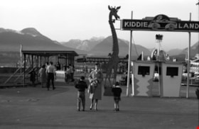
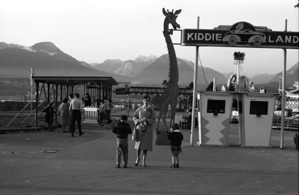
- Photograph of Frances Johnston and her children Sean and Wendy standing underneath a sign for "Kiddieland" at Playland in Vancouver. A large, giraffe-shaped signboard can be seen next to the entrance booths and a number of amusement rides are visible in the background.
- Repository
- City of Burnaby Archives
- Date
- 1964
- Collection/Fonds
- Harold H. Johnston fonds
- Physical Description
- 1 photograph (jpeg) : b&w
- Description Level
- Item
- Record No.
- 483-030
- Access Restriction
- No restrictions
- Reproduction Restriction
- No reproduction permitted
- Accession Number
- 2008-08
- Scope and Content
- Photograph of Frances Johnston and her children Sean and Wendy standing underneath a sign for "Kiddieland" at Playland in Vancouver. A large, giraffe-shaped signboard can be seen next to the entrance booths and a number of amusement rides are visible in the background.
- Media Type
- Photograph
- Photographer
- Johnston, Harold H.
- Notes
- Title based on contents of photograph
Images
![Lougheed Hotel, [1960] thumbnail](/media/hpo/_Data/_Archives_Images/_Unrestricted/001/078-001.jpg?width=280)
Lougheed Hotel
https://search.heritageburnaby.ca/link/archivedescription34644
- Repository
- City of Burnaby Archives
- Date
- [1960]
- Collection/Fonds
- Burnaby Historical Society fonds
- Description Level
- Item
- Physical Description
- 1 photograph : b&w ; 18.3 x 24.2 cm
- Scope and Content
- Photograph of the Lougheed Hotel on Lougheed Highway. Electric "Hotel" and "Vacancy" signs can be seen. A board advertises, "Smorgasbord Fri & Sat April 4th On, Ph GL 0221." "TV" is also advertised.
- Repository
- City of Burnaby Archives
- Date
- [1960]
- Collection/Fonds
- Burnaby Historical Society fonds
- Subseries
- Photographs subseries
- Physical Description
- 1 photograph : b&w ; 18.3 x 24.2 cm
- Description Level
- Item
- Record No.
- 078-001
- Access Restriction
- No restrictions
- Reproduction Restriction
- Reproduce for fair dealing purposes only
- Accession Number
- BHS2007-04
- Scope and Content
- Photograph of the Lougheed Hotel on Lougheed Highway. Electric "Hotel" and "Vacancy" signs can be seen. A board advertises, "Smorgasbord Fri & Sat April 4th On, Ph GL 0221." "TV" is also advertised.
- Names
- Lougheed Hotel
- Media Type
- Photograph
- Notes
- Title based on contents of photograph
- Geographic Access
- Lougheed Highway
- Street Address
- 4343 Lougheed Highway
- Historic Neighbourhood
- Vancouver Heights (Historic Neighbourhood)
- Planning Study Area
- Willingdon Heights Area
Images
![Lougheed Hotel, [1960] thumbnail](/media/hpo/_Data/_Archives_Images/_Unrestricted/001/078-001.jpg)
![Rob Walsh, [1969] thumbnail](/media/hpo/_Data/_Archives_Images/_Unrestricted/480/480-1051.jpg?width=280)
Rob Walsh
https://search.heritageburnaby.ca/link/archivedescription46163
- Repository
- City of Burnaby Archives
- Date
- [1969]
- Collection/Fonds
- Columbian Newspaper collection
- Description Level
- Item
- Physical Description
- 1 photograph : b&w ; 11.5 x 16.5 cm
- Scope and Content
- Photograph of Rob Walsh during his campaign as the provincial Liberal Party candidate for Burnaby-Edmonds. He is standing at the side of a campervan that is covered in campaign posters, speaking to an unidentified man in a suit and top coat. Another unidentified man is visible in the background.
- Repository
- City of Burnaby Archives
- Date
- [1969]
- Collection/Fonds
- Columbian Newspaper collection
- Physical Description
- 1 photograph : b&w ; 11.5 x 16.5 cm
- Description Level
- Item
- Record No.
- 480-1051
- Access Restriction
- No restrictions
- Reproduction Restriction
- Reproduce for fair dealing purposes only
- Accession Number
- 2003-02
- Scope and Content
- Photograph of Rob Walsh during his campaign as the provincial Liberal Party candidate for Burnaby-Edmonds. He is standing at the side of a campervan that is covered in campaign posters, speaking to an unidentified man in a suit and top coat. Another unidentified man is visible in the background.
- Names
- Walsh, Rob
- Liberal Party
- Media Type
- Photograph
- Notes
- Title based on contents of photograph
Images
![Rob Walsh, [1969] thumbnail](/media/hpo/_Data/_Archives_Images/_Unrestricted/480/480-1051.jpg)

Tommy Douglas at Confederation Park
https://search.heritageburnaby.ca/link/archivedescription51470
- Repository
- City of Burnaby Archives
- Date
- 1968
- Collection/Fonds
- Harold H. Johnston fonds
- Description Level
- Item
- Physical Description
- 1 photograph (jpeg) : b&w
- Scope and Content
- Photograph of a crowd of people gathered to listen to Tommy Douglas deliver a speech at Confederation Park. A few people in the audience are holding signs that read "Re-elect Douglas." Tommy Douglas served as the MP for Burnaby-Coquitlam from 1962 to 1968. He went on to become the 7th Premier of S…
- Repository
- City of Burnaby Archives
- Date
- 1968
- Collection/Fonds
- Harold H. Johnston fonds
- Physical Description
- 1 photograph (jpeg) : b&w
- Description Level
- Item
- Record No.
- 483-071
- Access Restriction
- No restrictions
- Reproduction Restriction
- No reproduction permitted
- Accession Number
- 2008-08
- Scope and Content
- Photograph of a crowd of people gathered to listen to Tommy Douglas deliver a speech at Confederation Park. A few people in the audience are holding signs that read "Re-elect Douglas." Tommy Douglas served as the MP for Burnaby-Coquitlam from 1962 to 1968. He went on to become the 7th Premier of Saskatchewan.
- Subjects
- Persons - Crowds
- Officials - Premiers
- Officials - Alderman and Councillors
- Advertising Medium - Signs and Signboards
- Names
- Douglas, Tommy
- Media Type
- Photograph
- Photographer
- Johnston, Harold H.
- Notes
- Title based on contents of photograph
- Geographic Access
- Willingdon Avenue
- Street Address
- 250 Willingdon Avenue
- Historic Neighbourhood
- Capitol Hill (Historic Neighbourhood)
- Planning Study Area
- Capitol Hill Area
Images

![Burnaby Alderman, Bill (William) Lewarne, [1973]. Item no. 231-012 thumbnail](/media/hpo/_Data/_Archives_Images/_Unrestricted/205/231-012.jpg?width=280)
Interview with William A. Lewarne by Rod Fowler March 14, 1990 - Track 3
https://search.heritageburnaby.ca/link/oralhistory443
- Repository
- City of Burnaby Archives
- Date Range
- 1930-1990
- Length
- 00:07:58
- Summary
- This portion of the interview is about the interurban tram service in Burnaby, how it was used, the interurban routes, reasons for closing the interurban and later building Skytrain, and attempts to purchase an old tram car for Heritage Village
- Repository
- City of Burnaby Archives
- Summary
- This portion of the interview is about the interurban tram service in Burnaby, how it was used, the interurban routes, reasons for closing the interurban and later building Skytrain, and attempts to purchase an old tram car for Heritage Village
- Date Range
- 1930-1990
- Photo Info
- Burnaby Alderman, Bill (William) Lewarne, [1973]. Item no. 231-012
- Length
- 00:07:58
- Interviewer
- Fowler, Rod
- Interview Date
- March 14, 1990
- Scope and Content
- Recording is of an interview with former Mayor William “Bill” Lewarne, conducted by Rod Fowler. Bill Lewarne was one of eleven participants interviewed as part of the SFU/Burnaby Centennial Committee's oral history series titled, "Voices of Burnaby". The interview is mainly about Bill Lewarne’s business and political careers, and memories of growing up in South Burnaby in the 1930s. Bill Lewarne talks about his parent’s origins, his family and community struggles during the Depression, the interurban, his education, war service, and joining his father's business. He describes the start, operation and expansion of the family ice cream business, and how business life compared to political life. The interview explores the role of politics in community affairs, his political activities, the history of the BVA, and his involvement in various community organizations. To view “Narrow By” terms for each track, expand this description and see “Notes”.
- Biographical Notes
- William Alfred “Bill” Lewarne was born in Burnaby in 1926 to Ethel Cecilia Leer (1899- ) and Alfred Lewarne (1893-1962). The family, Ethel, Alfred and their three children Patricia, Beverley and William, moved to a house on Nelson Avenue in Alta Vista in 1931. Ethel still lived in the family home in 1990. Bill Lewarne attended Nelson Avenue School and South Burnaby High School (1932-1944). His father Alfred worked at Colony Farms as a dairy inspector and then for the Port of Vancouver Dairy before being laid off early in the Depression. The family struggled until in 1936 Alfred started his own ice cream business. After graduation Bill was in the army for two years, taking a refrigeration course under the veteran’s training benefit, before joining his father’s business. Three generations of the family operated the successful company, expanding from wholesale, retail and distribution of ice cream products into refrigerated warehouses and the wholesale ice business, until the business was sold to its competitor Dairyland in 1989. Bill Lewarne entered politics in 1965, first with the Nonpartisan Association (NPA) and then as a founder of the Burnaby Citizens Association (BCA). He served as an alderman on Burnaby Council 1973-1975 and 1977-1981 and as Mayor 1981-1987. In 1979 he ran for provincial office for the Social Credit Party against Rosemary Brown but lost. Bill Lewarne married June Lawrence and they had three children Robert, Leslie and Janice. He was active in many organizations: Burnaby/Willingdon Liberal Association, Seton Villa, Irish Fusileers of Canada, Lions Club, Rotary Club, Burnaby Association for Community Inclusion, and the Burnaby Hospital Foundation, and continued to be active on the Board of the BCA. Bill Lewarne died in 1995.
- Total Tracks
- 14
- Total Length
- 1:34:40
- Interviewee Name
- Lewarne, William A. "Bill"
- Interviewer Bio
- Rod Fowler returned to university as a mature student in the 1980s after working about twenty years in the field of economics and business computerization in England, Europe and Western Canada. He graduated with a BA from SFU in both History and Sociology in 1987, his MA degree in Geography in 1989, and his PhD in Cultural Geography at SFU. He taught courses in Geography, Sociology, History and Canadian Studies at several Lower Mainland colleges, before becoming a full time member of the Geography Department at Kwantlen University College.
- Collection/Fonds
- SFU/Burnaby Centennial Committee fonds
- Transcript Available
- Transcript available
- Media Type
- Sound Recording
- Web Notes
- Interviews were digitized in 2015 allowing them to be accessible on Heritage Burnaby. The digitization project was initiated by the Community Heritage Commission with support from City of Burnaby Council.
Images
![Burnaby Alderman, Bill (William) Lewarne, [1973]. Item no. 231-012 thumbnail](/media/hpo/_Data/_Archives_Images/_Unrestricted/205/231-012.jpg)
Audio Tracks
Track three of interview with Bill Lewarne
Track three of interview with Bill Lewarne
https://search.heritageburnaby.ca/media/hpo/_Data/_Archives_Oral_Histories/_Unrestricted/MSS187-019/MSS187-019_Track_3.mp3The time of the trolley
https://search.heritageburnaby.ca/link/museumlibrary796
- Repository
- Burnaby Village Museum
- Collection
- Reference Collection
- Material Type
- Book
- Call Number
- 388.4 MID
- Place of Publication
- Milwaukee, Wis.
- Publisher
- Kalmbach
- Publication Date
- c1967
- Physical Description
- 436 p. : ill.
- Library Subject (LOC)
- Street-railroads
- Electric railroads
- Transportation
- Notes
- Includes index.
Edmonds Bus Loop
https://search.heritageburnaby.ca/link/archivedescription34597
- Repository
- City of Burnaby Archives
- Date
- July 15, 1966
- Collection/Fonds
- Burnaby Historical Society fonds
- Description Level
- Item
- Physical Description
- 1 photograph : b&w negative ; 4.7 x 4.6 cm
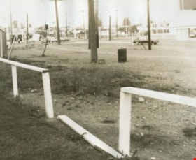
- Scope and Content
- Photograph of the Edmonds Bus Loop at Edmonds Street and Kingsway with a broken fence in the foreground. No buses are visible.
- Repository
- City of Burnaby Archives
- Date
- July 15, 1966
- Collection/Fonds
- Burnaby Historical Society fonds
- Subseries
- Photographs subseries
- Physical Description
- 1 photograph : b&w negative ; 4.7 x 4.6 cm
- Description Level
- Item
- Record No.
- 066-001
- Access Restriction
- No restrictions
- Reproduction Restriction
- Reproduce for fair dealing purposes only
- Accession Number
- BHS2007-04
- Scope and Content
- Photograph of the Edmonds Bus Loop at Edmonds Street and Kingsway with a broken fence in the foreground. No buses are visible.
- Subjects
- Transportation - Public Transit
- Media Type
- Photograph
- Notes
- Title based on contents of photograph
- 1 b&w photograph accompanying
- Geographic Access
- Kingsway
- Edmonds Street
- Historic Neighbourhood
- Edmonds (Historic Neighbourhood)
- Planning Study Area
- Stride Avenue Area
Images


Edmonds Bus Loop
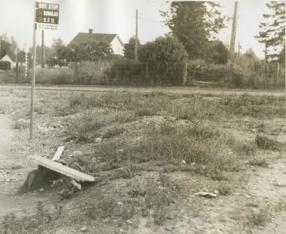
https://search.heritageburnaby.ca/link/archivedescription34598
- Repository
- City of Burnaby Archives
- Date
- July 15, 1966
- Collection/Fonds
- Burnaby Historical Society fonds
- Description Level
- Item
- Physical Description
- 1 photograph : b&w negative ; 4.4 x 4.5 cm
- Scope and Content
- Photograph of the Edmonds Bus Loop at Edmonds Street and Kingsway. There is a bus stop sign for the 31 Douglas and 58 SFU with "For bus information phone 261-4211" written at the bottom. No buses are visible.
- Repository
- City of Burnaby Archives
- Date
- July 15, 1966
- Collection/Fonds
- Burnaby Historical Society fonds
- Subseries
- Photographs subseries
- Physical Description
- 1 photograph : b&w negative ; 4.4 x 4.5 cm
- Description Level
- Item
- Record No.
- 066-002
- Access Restriction
- No restrictions
- Reproduction Restriction
- Reproduce for fair dealing purposes only
- Accession Number
- BHS2007-04
- Scope and Content
- Photograph of the Edmonds Bus Loop at Edmonds Street and Kingsway. There is a bus stop sign for the 31 Douglas and 58 SFU with "For bus information phone 261-4211" written at the bottom. No buses are visible.
- Subjects
- Transportation - Public Transit
- Media Type
- Photograph
- Notes
- Title based on contents of photograph
- 1 b&w photograph accompanying
- Geographic Access
- Kingsway
- Edmonds Street
- Historic Neighbourhood
- Edmonds (Historic Neighbourhood)
- Planning Study Area
- Stride Avenue Area
Images