Narrow Results By
Person / Organization
- Alpha Secondary School 1
- Burnaby Central Secondary School 1
- Cascade Heights Elementary School 1
- Cliff's Can Factory 3
- Gilmore Avenue School 1
- Gooden, Tom 1
- James Brookes Woodworking Limited 3
- Lawson, Doreen A. 1
- Moscrop Secondary School 1
- Schou Street School 1
- Western Canadian Can Factory 3
- White, Janet 1

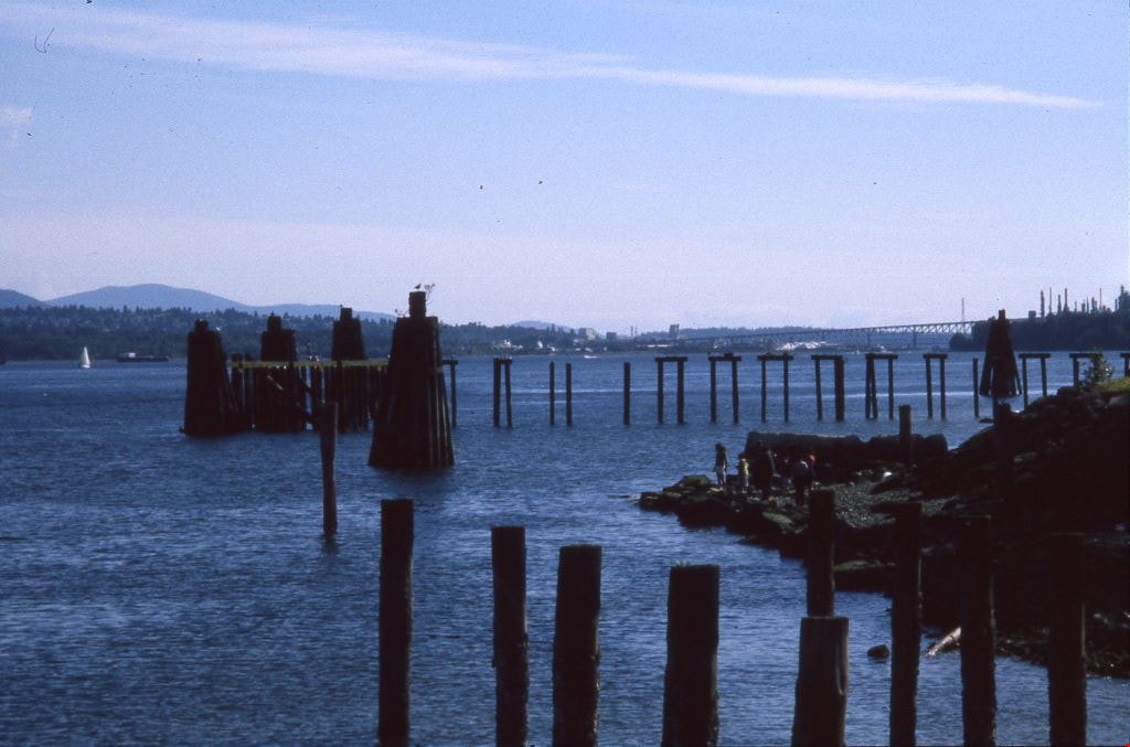
Barnet Marine Park
https://search.heritageburnaby.ca/link/archivedescription91581
- Repository
- City of Burnaby Archives
- Date
- August 9, 1996
- Collection/Fonds
- Doreen Lawson fonds
- Description Level
- File
- Physical Description
- 18 photographs : col. slides ; 35 mm
- Scope and Content
- File consists of photographs of Barnet Marine Park, including Barnet Beach pilings, overpass and people preparing kayaks on the shore.
- Repository
- City of Burnaby Archives
- Date
- August 9, 1996
- Collection/Fonds
- Doreen Lawson fonds
- Physical Description
- 18 photographs : col. slides ; 35 mm
- Description Level
- File
- Record No.
- 605-014
- Access Restriction
- No restrictions
- Reproduction Restriction
- No restrictions
- Accession Number
- 2003-30
- Scope and Content
- File consists of photographs of Barnet Marine Park, including Barnet Beach pilings, overpass and people preparing kayaks on the shore.
- Names
- Lawson, Doreen A.
- Media Type
- Photograph
- Photographer
- Lawson, Doreen A.
- Notes
- Title based on contents of photographs
- Note in black in on recto of slide frames of photographs 605-014-1 : 605-014-7, 605-014-9 : 605-014-11, and 605-014-13 reads: "Barnet Beach Pilings"
- Note in black ink on recto of slide frames of photographs 605-014-8 and 605-014-12 reads: "Barnet Beach Kayaks"
- Note in black ink on recto of slide frames of photographs 605-014-14 : 605-014-18 reads: "Barnet Beach Overpass"
- Geographic Access
- Barnet Marine Park
- Historic Neighbourhood
- Barnet (Historic Neighbourhood)
- Planning Study Area
- Burnaby Mountain Area
Images


Barnet Marine Park
https://search.heritageburnaby.ca/link/archivedescription91696
- Repository
- City of Burnaby Archives
- Date
- August 25, 1999
- Collection/Fonds
- Doreen Lawson fonds
- Description Level
- File
- Physical Description
- 20 photographs : col. slides ; 35 mm
- Scope and Content
- File consists of photographs of Barnet Marine Park, including the Barnet Beach pilings, people exploring the rocky shoreline and a woman sitting on a bench in the park.
- Repository
- City of Burnaby Archives
- Date
- August 25, 1999
- Collection/Fonds
- Doreen Lawson fonds
- Physical Description
- 20 photographs : col. slides ; 35 mm
- Description Level
- File
- Record No.
- 618-014
- Access Restriction
- No restrictions
- Reproduction Restriction
- No restrictions
- Accession Number
- 2015-15
- Scope and Content
- File consists of photographs of Barnet Marine Park, including the Barnet Beach pilings, people exploring the rocky shoreline and a woman sitting on a bench in the park.
- Media Type
- Photograph
- Photographer
- Lawson, Doreen A.
- Notes
- Title based on contents of photographs
- Geographic Access
- Barnet Marine Park
- Historic Neighbourhood
- Barnet (Historic Neighbourhood)
- Planning Study Area
- Burnaby Mountain Area
Images
Interview with Janet White May 10, 2005 - Track 1
https://search.heritageburnaby.ca/link/museumdescription4370
- Repository
- Burnaby Village Museum
- Date
- [195-] (interview content), interviewed May 10, 2005
- Collection/Fonds
- Burnaby Village Museum fonds
- Description Level
- Item
- Physical Description
- 1 sound recording (mp3) (0:03:12 min)
- Scope and Content
- Track 1: This portion of the recording pertains to Janet White’s school years and the activities and sports she participated in, formally and informally. She lived near 6th and Edmonds St., and then in the Cascades area, by Nithsdale St., and attended Schou Elementary. She attended many schools as …
- Repository
- Burnaby Village Museum
- Collection/Fonds
- Burnaby Village Museum fonds
- Series
- Museum Oral Histories series
- Subseries
- Growing Up in Burnaby subseries
- Description Level
- Item
- Physical Description
- 1 sound recording (mp3) (0:03:12 min)
- Material Details
- Interviewer: Tom Gooden Interviewee: Janet White Date of interview: May 10, 2005 Total Number of Tracks: 8 Total length of all Tracks: 0:31:34
- Scope and Content
- Track 1: This portion of the recording pertains to Janet White’s school years and the activities and sports she participated in, formally and informally. She lived near 6th and Edmonds St., and then in the Cascades area, by Nithsdale St., and attended Schou Elementary. She attended many schools as soon as they were built, attending Gilmore Avenue, then Cascade Heights, Alpha Junior High, Moscrop Secondary, and finally Burnaby Central Secondary. Play was unstructured, with the Cascades bush and the tunnel parallel to and going under Smith Avenue being favourite places to play.
- History
- Recording of an interview with Janet White recording by Tom Gooden on May 10 2005. This recording was completed for an exhibit, Growing Up in Burnaby, for the Burnaby Village Museum. Major themes discussed are growing up in Burnaby in the 1950s.
- Creator
- Burnaby Village Museum
- Names
- Gooden, Tom
- White, Janet
- Schou Street School
- Gilmore Avenue School
- Cascade Heights Elementary School
- Alpha Secondary School
- Moscrop Secondary School
- Burnaby Central Secondary School
- Geographic Access
- 6th Street
- Edmonds Street
- Accession Code
- BV017.45.1
- Access Restriction
- No restrictions
- Reproduction Restriction
- May be restricted by third party rights
- Date
- [195-] (interview content), interviewed May 10, 2005
- Media Type
- Sound Recording
- Planning Study Area
- Cascade-Schou Area
Audio Tracks
Interview with Janet White May 10, 2005 - Track 1, [195-] (interview content), interviewed May 10, 2005
Interview with Janet White May 10, 2005 - Track 1, [195-] (interview content), interviewed May 10, 2005
https://search.heritageburnaby.ca/media/hpo/_Data/_BVM_Sound_Recordings/Oral_Histories/2017_0045_0001_001.mp3
Moxham family house
https://search.heritageburnaby.ca/link/archivedescription34818
- Repository
- City of Burnaby Archives
- Date
- 1929
- Collection/Fonds
- Burnaby Historical Society fonds
- Description Level
- Item
- Physical Description
- 1 photograph : b&w ; 7.0 x 11.5 cm
- Scope and Content
- Photograph of the exterior of the Moxham family house at 1944 6th Street (later renumbered 7337 6th Street). This house was built in 1914 by Mr. Godfrey Moxham.
- Repository
- City of Burnaby Archives
- Date
- 1929
- Collection/Fonds
- Burnaby Historical Society fonds
- Subseries
- Kathleen Moore family subseries
- Physical Description
- 1 photograph : b&w ; 7.0 x 11.5 cm
- Description Level
- Item
- Record No.
- 139-001
- Access Restriction
- No restrictions
- Reproduction Restriction
- No known restrictions
- Accession Number
- BHS1985-09
- Scope and Content
- Photograph of the exterior of the Moxham family house at 1944 6th Street (later renumbered 7337 6th Street). This house was built in 1914 by Mr. Godfrey Moxham.
- Subjects
- Buildings - Residential - Houses
- Media Type
- Photograph
- Notes
- Title based on contents of photograph
- Geographic Access
- 6th Street
- Street Address
- 7337 6th Street
- Historic Neighbourhood
- East Burnaby (Historic Neighbourhood)
- Planning Study Area
- Edmonds Area
Images

![Moxham residence, [1929] (date of original) copied [2000] thumbnail](/media/hpo/_Data/_Archives_Images/_Unrestricted/371/388-001.jpg?width=280)
Moxham residence
https://search.heritageburnaby.ca/link/archivedescription38285
- Repository
- City of Burnaby Archives
- Date
- [1929] (date of original) copied [2000]
- Collection/Fonds
- Burnaby Historical Society fonds
- Description Level
- Item
- Physical Description
- 1 photograph : b&w ; 12.7 x 17.7 cm print
- Scope and Content
- Photograph of the Moxham residence, located at 1944 6th Street (old street numbering system). A note written on the back of the photograph reads: "Moxham residence, 1944 Sixth St., Burnaby. Built 1914 by Mr. Moxham. Photo taken ca. 1929."
- Repository
- City of Burnaby Archives
- Date
- [1929] (date of original) copied [2000]
- Collection/Fonds
- Burnaby Historical Society fonds
- Subseries
- Photographs subseries
- Physical Description
- 1 photograph : b&w ; 12.7 x 17.7 cm print
- Description Level
- Item
- Record No.
- 388-001
- Access Restriction
- No restrictions
- Reproduction Restriction
- No known restrictions
- Accession Number
- BHS2007-04
- Scope and Content
- Photograph of the Moxham residence, located at 1944 6th Street (old street numbering system). A note written on the back of the photograph reads: "Moxham residence, 1944 Sixth St., Burnaby. Built 1914 by Mr. Moxham. Photo taken ca. 1929."
- Media Type
- Photograph
- Notes
- Title based on caption
- Geographic Access
- 6th Street
- Historic Neighbourhood
- East Burnaby (Historic Neighbourhood)
- Planning Study Area
- Second Street Area
Images
![Moxham residence, [1929] (date of original) copied [2000] thumbnail](/media/hpo/_Data/_Archives_Images/_Unrestricted/371/388-001.jpg)
![Woodworking Plant, [192-] (date of original), copied 1986 thumbnail](/media/hpo/_Data/_Archives_Images/_Unrestricted/204/204-106.jpg?width=280)
Woodworking Plant
https://search.heritageburnaby.ca/link/archivedescription35249
- Repository
- City of Burnaby Archives
- Date
- [192-] (date of original), copied 1986
- Collection/Fonds
- Burnaby Historical Society fonds
- Description Level
- Item
- Physical Description
- 1 photograph : b&w ; 12.7 x 17.8 cm print
- Scope and Content
- Photograph of James Brookes Woodworking Plant located at 7730 6th Street. This site has also served as Cliff's Can Factory and Western Canadian Can Factory. Note the spur street car line (no. 2) where B.C. Electric Railway freight cars could load and unload.
- Repository
- City of Burnaby Archives
- Date
- [192-] (date of original), copied 1986
- Collection/Fonds
- Burnaby Historical Society fonds
- Subseries
- Pioneer Tales subseries
- Physical Description
- 1 photograph : b&w ; 12.7 x 17.8 cm print
- Description Level
- Item
- Record No.
- 204-106
- Access Restriction
- No restrictions
- Reproduction Restriction
- No known restrictions
- Accession Number
- BHS1988-03
- Scope and Content
- Photograph of James Brookes Woodworking Plant located at 7730 6th Street. This site has also served as Cliff's Can Factory and Western Canadian Can Factory. Note the spur street car line (no. 2) where B.C. Electric Railway freight cars could load and unload.
- Subjects
- Buildings - Industrial - Factories
- Media Type
- Photograph
- Notes
- Title based on contents of photograph
- Geographic Access
- 6th Street
- Street Address
- 7730 6th Street
- Historic Neighbourhood
- East Burnaby (Historic Neighbourhood)
- Planning Study Area
- Second Street Area
Images
![Woodworking Plant, [192-] (date of original), copied 1986 thumbnail](/media/hpo/_Data/_Archives_Images/_Unrestricted/204/204-106.jpg)
![Woodworking Plant, [192-] (date of original), copied 1986 thumbnail](/media/hpo/_Data/_Archives_Images/_Unrestricted/204/204-107.jpg?width=280)
Woodworking Plant
https://search.heritageburnaby.ca/link/archivedescription35250
- Repository
- City of Burnaby Archives
- Date
- [192-] (date of original), copied 1986
- Collection/Fonds
- Burnaby Historical Society fonds
- Description Level
- Item
- Physical Description
- 1 photograph : b&w ; 12.7 x 17.8 cm print
- Scope and Content
- Photograph of James Brookes Woodworking Plant, located at 7730 6th Street, taken from 13th Avenue. This site has also served as Cliff's Can Factory and Western Canadian Can Factory.
- Repository
- City of Burnaby Archives
- Date
- [192-] (date of original), copied 1986
- Collection/Fonds
- Burnaby Historical Society fonds
- Subseries
- Pioneer Tales subseries
- Physical Description
- 1 photograph : b&w ; 12.7 x 17.8 cm print
- Description Level
- Item
- Record No.
- 204-107
- Access Restriction
- No restrictions
- Reproduction Restriction
- No known restrictions
- Accession Number
- BHS1988-03
- Scope and Content
- Photograph of James Brookes Woodworking Plant, located at 7730 6th Street, taken from 13th Avenue. This site has also served as Cliff's Can Factory and Western Canadian Can Factory.
- Subjects
- Buildings - Industrial - Factories
- Media Type
- Photograph
- Notes
- Title based on contents of photograph
- Geographic Access
- 6th Street
- Street Address
- 7730 6th Street
- Historic Neighbourhood
- East Burnaby (Historic Neighbourhood)
- Planning Study Area
- Second Street Area
Images
![Woodworking Plant, [192-] (date of original), copied 1986 thumbnail](/media/hpo/_Data/_Archives_Images/_Unrestricted/204/204-107.jpg)
![Woodworking Plant, [192-] (date of original), copied 1986 thumbnail](/media/hpo/_Data/_Archives_Images/_Unrestricted/204/204-108.jpg?width=280)
Woodworking Plant
https://search.heritageburnaby.ca/link/archivedescription35251
- Repository
- City of Burnaby Archives
- Date
- [192-] (date of original), copied 1986
- Collection/Fonds
- Burnaby Historical Society fonds
- Description Level
- Item
- Physical Description
- 1 photograph : b&w ; 12.7 x 17.8 cm print
- Scope and Content
- Photograph of James Brookes Woodworking Plant, located at 7730 6th Street, taken from 6th Street. It was an East Burnaby landmark, established in 1902 as a can company by Edwin Cliff. This site has also served as Cliff's Can Factory and Western Canadian Can Factory.
- Repository
- City of Burnaby Archives
- Date
- [192-] (date of original), copied 1986
- Collection/Fonds
- Burnaby Historical Society fonds
- Subseries
- Pioneer Tales subseries
- Physical Description
- 1 photograph : b&w ; 12.7 x 17.8 cm print
- Description Level
- Item
- Record No.
- 204-108
- Access Restriction
- No restrictions
- Reproduction Restriction
- No known restrictions
- Accession Number
- BHS1988-03
- Scope and Content
- Photograph of James Brookes Woodworking Plant, located at 7730 6th Street, taken from 6th Street. It was an East Burnaby landmark, established in 1902 as a can company by Edwin Cliff. This site has also served as Cliff's Can Factory and Western Canadian Can Factory.
- Subjects
- Buildings - Industrial - Factories
- Media Type
- Photograph
- Notes
- Title based on contents of photograph
- Geographic Access
- 6th Street
- Street Address
- 7730 6th Street
- Historic Neighbourhood
- East Burnaby (Historic Neighbourhood)
- Planning Study Area
- Second Street Area
Images
![Woodworking Plant, [192-] (date of original), copied 1986 thumbnail](/media/hpo/_Data/_Archives_Images/_Unrestricted/204/204-108.jpg)