Narrow Results By
Subject
- Buildings - Civic 1
- Buildings - Commercial - Restaurants 1
- Buildings - Recreational 1
- Buildings - Recreational - Community Halls 1
- Buildings - Schools 2
- Geographic Features - Automobile Parking Lots 2
- Geographic Features - Mountains 1
- Geographic Features - Parks 2
- Geographic Features - Roads 1
- Transportation - Automobiles 1

Burnaby Mountain Parking Lot & Restaurant
https://search.heritageburnaby.ca/link/archivedescription93706
- Repository
- City of Burnaby Archives
- Date
- February 15, 1978
- Collection/Fonds
- Burnaby Public Library Contemporary Visual Archive Project
- Description Level
- Item
- Physical Description
- 1 photograph : b&w ; 12.5 x 17.5 cm
- Scope and Content
- Photograph of the view of the mountains and park from a hill on Burnaby Mountain Park. The photograph is taken facing north. The photograph shows the parking lot and the Burnaby Mountain Centennial Pavilion.
- Repository
- City of Burnaby Archives
- Date
- February 15, 1978
- Collection/Fonds
- Burnaby Public Library Contemporary Visual Archive Project
- Physical Description
- 1 photograph : b&w ; 12.5 x 17.5 cm
- Description Level
- Item
- Record No.
- 556-663
- Access Restriction
- No restrictions
- Reproduction Restriction
- Reproduce for fair dealing purposes only
- Accession Number
- 2017-57
- Scope and Content
- Photograph of the view of the mountains and park from a hill on Burnaby Mountain Park. The photograph is taken facing north. The photograph shows the parking lot and the Burnaby Mountain Centennial Pavilion.
- Subjects
- Buildings - Commercial - Restaurants
- Buildings - Civic
- Buildings - Recreational
- Geographic Features - Automobile Parking Lots
- Geographic Features - Parks
- Names
- Burnaby Mountain Park
- Media Type
- Photograph
- Photographer
- Surridge, Jack
- Notes
- Title taken from project information form
- Accompanied by a project information form and 1 photograph (b&w negative ; 9.5 x 12.5 cm)
- BPL no. 111
- Geographic Access
- Burnaby Lake Regional Nature Park
- Burnaby Mountain Conservation Area
- Street Address
- 100 Centennial Way
- Planning Study Area
- Burnaby Mountain Area
Images


Burnaby Mountain Park Looking West
https://search.heritageburnaby.ca/link/archivedescription93707
- Repository
- City of Burnaby Archives
- Date
- February 15, 1978
- Collection/Fonds
- Burnaby Public Library Contemporary Visual Archive Project
- Description Level
- Item
- Physical Description
- 1 photograph : b&w ; 12.5 x 17.5 cm
- Scope and Content
- Photograph of the view from Burnaby Mountain Park. The photograph is taken facing west and shows the park, part of the parking lot at the Burnaby Centennial Pavilion, and Capitol Hill and the mountains in the distance.
- Repository
- City of Burnaby Archives
- Date
- February 15, 1978
- Collection/Fonds
- Burnaby Public Library Contemporary Visual Archive Project
- Physical Description
- 1 photograph : b&w ; 12.5 x 17.5 cm
- Description Level
- Item
- Record No.
- 556-664
- Access Restriction
- No restrictions
- Reproduction Restriction
- Reproduce for fair dealing purposes only
- Accession Number
- 2017-57
- Scope and Content
- Photograph of the view from Burnaby Mountain Park. The photograph is taken facing west and shows the park, part of the parking lot at the Burnaby Centennial Pavilion, and Capitol Hill and the mountains in the distance.
- Subjects
- Geographic Features - Parks
- Geographic Features - Mountains
- Geographic Features - Automobile Parking Lots
- Names
- Burnaby Mountain Park
- Media Type
- Photograph
- Photographer
- Surridge, Jack
- Notes
- Title taken from project information form
- Accompanied by a project information form and 1 photograph (b&w negative ; 9.5 x 12.5 cm)
- BPL no. 112
- Geographic Access
- Burnaby Mountain Conservation Area
- Street Address
- 100 Centennial Way
- Planning Study Area
- Burnaby Mountain Area
Images

Capitol Hill School
https://search.heritageburnaby.ca/link/archivedescription93644
- Repository
- City of Burnaby Archives
- Date
- November 19, 1977
- Collection/Fonds
- Burnaby Public Library Contemporary Visual Archive Project
- Description Level
- Item
- Physical Description
- 1 photograph : b&w ; 12.5 x 17.5 cm
- Scope and Content
- Photograph of the exterior of Capitol Hill Elementary School, located at the corner of Hastings Street and Holdom Avenue. The photograph is taken from across the lawn, facing southwest. Two discarded bicycles are on the lawn in the foregound.
- Repository
- City of Burnaby Archives
- Date
- November 19, 1977
- Collection/Fonds
- Burnaby Public Library Contemporary Visual Archive Project
- Physical Description
- 1 photograph : b&w ; 12.5 x 17.5 cm
- Description Level
- Item
- Record No.
- 556-601
- Access Restriction
- No restrictions
- Reproduction Restriction
- Reproduce for fair dealing purposes only
- Accession Number
- 2017-57
- Scope and Content
- Photograph of the exterior of Capitol Hill Elementary School, located at the corner of Hastings Street and Holdom Avenue. The photograph is taken from across the lawn, facing southwest. Two discarded bicycles are on the lawn in the foregound.
- Subjects
- Buildings - Schools
- Media Type
- Photograph
- Photographer
- Surridge, Jack
- Notes
- Title taken from project information form
- Accompanied by a project information form and 1 photograph (b&w negative ; 9.5 x 12.5 cm)
- BPL no. 51
- Geographic Access
- Hastings Street
- Holdom Avenue
- Street Address
- 350 Holdom Avenue
- Historic Neighbourhood
- Capitol Hill (Historic Neighbourhood)
- Planning Study Area
- Capitol Hill Area
Images


Deer Crossing Sign on Road to SFU
https://search.heritageburnaby.ca/link/archivedescription93671
- Repository
- City of Burnaby Archives
- Date
- January 18, 1978
- Collection/Fonds
- Burnaby Public Library Contemporary Visual Archive Project
- Description Level
- Item
- Physical Description
- 1 photograph : b&w ; 12.5 x 17.5 cm
- Scope and Content
- Photograph of the road to Simon Fraser University on Burnaby Mountain, with a deer crossing sign on the right-hand side of the photograph and a car driving ahead. The photograph appears to be taken from a car parked on the shoulder of the road, facing east.
- Repository
- City of Burnaby Archives
- Date
- January 18, 1978
- Collection/Fonds
- Burnaby Public Library Contemporary Visual Archive Project
- Physical Description
- 1 photograph : b&w ; 12.5 x 17.5 cm
- Description Level
- Item
- Record No.
- 556-628
- Access Restriction
- No restrictions
- Reproduction Restriction
- Reproduce for fair dealing purposes only
- Accession Number
- 2017-57
- Scope and Content
- Photograph of the road to Simon Fraser University on Burnaby Mountain, with a deer crossing sign on the right-hand side of the photograph and a car driving ahead. The photograph appears to be taken from a car parked on the shoulder of the road, facing east.
- Names
- Simon Fraser University
- Media Type
- Photograph
- Photographer
- Surridge, Jack
- Notes
- Title taken from project information form
- Accompanied by a project information form and 1 photograph (b&w negative ; 9.5 x 12.5 cm)
- BPL no. 77
- Geographic Access
- University Drive
- Burnaby Mountain Conservation Area
- Planning Study Area
- Burnaby Mountain Area
Images


Lochdale Community Hall
https://search.heritageburnaby.ca/link/archivedescription93672
- Repository
- City of Burnaby Archives
- Date
- January 18, 1978
- Collection/Fonds
- Burnaby Public Library Contemporary Visual Archive Project
- Description Level
- Item
- Physical Description
- 1 photograph : b&w ; 12.5 x 17.5 cm
- Scope and Content
- Photograph of the front exterior of Lochdale Community Hall, located near Sperling and Hastings Street and built in 1925. Cars are parked in front of and beside the hall. The photograph is taken from across the street, facing east.
- Repository
- City of Burnaby Archives
- Date
- January 18, 1978
- Collection/Fonds
- Burnaby Public Library Contemporary Visual Archive Project
- Physical Description
- 1 photograph : b&w ; 12.5 x 17.5 cm
- Description Level
- Item
- Record No.
- 556-629
- Access Restriction
- No restrictions
- Reproduction Restriction
- Reproduce for fair dealing purposes only
- Accession Number
- 2017-57
- Scope and Content
- Photograph of the front exterior of Lochdale Community Hall, located near Sperling and Hastings Street and built in 1925. Cars are parked in front of and beside the hall. The photograph is taken from across the street, facing east.
- Names
- Lochdale Community Hall
- Media Type
- Photograph
- Photographer
- Surridge, Jack
- Notes
- Title taken from project information form
- Accompanied by a project information form and 1 photograph (b&w negative ; 9.5 x 12.5 cm)
- BPL no. 78
- Geographic Access
- Hastings Street
- Sperling Avenue
- Street Address
- 490 Sperling Avenue
- Historic Neighbourhood
- Lochdale (Historic Neighbourhood)
- Planning Study Area
- Lochdale Area
Images

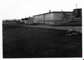
![Second Street School, [January 1978] thumbnail](/media/hpo/_Data/_Archives_Images/_Unrestricted/550/556-621.jpg?width=280)
Second Street School
https://search.heritageburnaby.ca/link/archivedescription93664
- Repository
- City of Burnaby Archives
- Date
- [January 1978]
- Collection/Fonds
- Burnaby Public Library Contemporary Visual Archive Project
- Description Level
- Item
- Physical Description
- 1 photograph : b&w ; 12.5 x 17.5 cm
- Scope and Content
- Photograph of the schoolyard and exterior of Second Street School. The photograph is taken from across the field, facing east. The photograph shows children playing in the field and the old school building, built in 1928, and the newer additions to the school. The mountains are visible in the backg…
- Repository
- City of Burnaby Archives
- Date
- [January 1978]
- Collection/Fonds
- Burnaby Public Library Contemporary Visual Archive Project
- Physical Description
- 1 photograph : b&w ; 12.5 x 17.5 cm
- Description Level
- Item
- Record No.
- 556-621
- Access Restriction
- No restrictions
- Reproduction Restriction
- Reproduce for fair dealing purposes only
- Accession Number
- 2017-57
- Scope and Content
- Photograph of the schoolyard and exterior of Second Street School. The photograph is taken from across the field, facing east. The photograph shows children playing in the field and the old school building, built in 1928, and the newer additions to the school. The mountains are visible in the background.
- Subjects
- Buildings - Schools
- Names
- Second Street School
- Media Type
- Photograph
- Photographer
- Surridge, Jack
- Notes
- Title taken from project information form
- Accompanied by a project information form and 1 photograph (b&w negative ; 9.5 x 12.5 cm)
- BPL no. 70
- Geographic Access
- 2nd Street
- Street Address
- 7502 2nd Street
- Historic Neighbourhood
- East Burnaby (Historic Neighbourhood)
- Planning Study Area
- Second Street Area
Images
![Second Street School, [January 1978] thumbnail](/media/hpo/_Data/_Archives_Images/_Unrestricted/550/556-621.jpg)