Narrow Results By
![Edwin Wettenhall Bateman, [1881] thumbnail](/media/hpo/_Data/_BVM_Images/1975/1975_0120_0008_001.jpg?width=280)
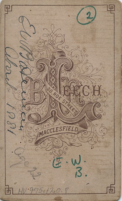
Edwin Wettenhall Bateman
https://search.heritageburnaby.ca/link/museumdescription906
- Repository
- Burnaby Village Museum
- Date
- [1881]
- Collection/Fonds
- E.W. Bateman family fonds
- Description Level
- Item
- Physical Description
- 1 photograph : sepia ; 8.9 x 6.1 cm mounted on card 10.4 x 6.3 cm
- Scope and Content
- Photograph of Edwin Wettenhall Bateman, about age twenty-two, taken in 1881 according to the inscription on the back. Edwin Bateman is wearing his hair short and parted down the middle, with sideburns and a moustache. His dark coat is buttoned high with one button and his tie is a band that fits on…
- Repository
- Burnaby Village Museum
- Collection/Fonds
- E.W. Bateman family fonds
- Description Level
- Item
- Physical Description
- 1 photograph : sepia ; 8.9 x 6.1 cm mounted on card 10.4 x 6.3 cm
- Scope and Content
- Photograph of Edwin Wettenhall Bateman, about age twenty-two, taken in 1881 according to the inscription on the back. Edwin Bateman is wearing his hair short and parted down the middle, with sideburns and a moustache. His dark coat is buttoned high with one button and his tie is a band that fits only under the collar and does not hang down below it. This photograph was probably taken shortly before E.W. Bateman left England for Manitoba. E.W. Bateman built the house "Elworth" at the Burnaby Village Museum.
- Names
- Bateman, Edwin W.
- Accession Code
- HV975.120.8
- Access Restriction
- No restrictions
- Reproduction Restriction
- No known restrictions
- Date
- [1881]
- Media Type
- Photograph
- Scan Resolution
- 600
- Scan Date
- 2023-06-13
- Photographer
- Leech, B.R.
- Notes
- Title based on contents of photograph
- Printed on the bottom front of the photograph: "B.R. Leech. Photo. / Macclesfield." P
- Printed inscription on veso of card reads: "B.R. Leech / 30, Roe Street. Macclesfield."
- Annotations on verso of card reads: "EW Bateman / About 1881 / Age 22 / E.W. / B."
Images
![Edwin Wettenhall Bateman, [1881] thumbnail](/media/hpo/_Data/_BVM_Images/1975/1975_0120_0008_001.jpg)
![Subdivision plans in New Westminster District Group 1 – Burnaby
, [1882-1910] thumbnail](/media/hpo/_Data/_BVM_Cartographic_Material/1977/1977_0093_0013a_001.jpg?width=280)
Subdivision plans in New Westminster District Group 1 – Burnaby
https://search.heritageburnaby.ca/link/museumdescription6982
- Repository
- Burnaby Village Museum
- Date
- [1882-1910]
- Collection/Fonds
- Burnaby Village Museum Map collection
- Description Level
- File
- Physical Description
- 4 plans : blueprint on paper mounted on 2 sides of cardboard 76 x 102 cm
- Scope and Content
- Item consists of a large board of two New Westminster District Gp 1 - subdivision plans mounted on one side and two New Westminster District Gp 1 - subdivision plans mounted on the other side. Side A: 1. Blueprint "Plan / of the / Subdivision / of / Lot 98 / G.1, N.W.D. / Scale 4 chs = 1 in. / …
- Repository
- Burnaby Village Museum
- Collection/Fonds
- Burnaby Village Museum Map collection
- Description Level
- File
- Physical Description
- 4 plans : blueprint on paper mounted on 2 sides of cardboard 76 x 102 cm
- Material Details
- Scales [between 1:1584 and 1:3168]
- Index number on edge of board reads: "13"
- Scope and Content
- Item consists of a large board of two New Westminster District Gp 1 - subdivision plans mounted on one side and two New Westminster District Gp 1 - subdivision plans mounted on the other side. Side A: 1. Blueprint "Plan / of the / Subdivision / of / Lot 98 / G.1, N.W.D. / Scale 4 chs = 1 in. / Map No 573" (Geographic location: Burnaby) 2. Blueprint "Plan / of Subdivision of / Lot 157 / Gr.1, New. West. Dist. / Scale 3 chs = 1 in. / Map No. 612". (Geographic location: Burnaby) Side B: 1. Blueprint "Plan / of Subdivision / of a Portion of / Lot 90 / Group One / New Westminster Dist. / Scale 2 chs = 1 in. / Map No. 555". Plan is signed by "Jno Strathern [sic]_P.L.S."n (Geographic location: Burnaby) 2. Blueprint "Subdivision of Lot 31, Group 1. / New Westminster District / As Amended by Order of Court / 1st Sept. 1882 and Numbered 847 / Scale 4 chs = 1in. / Map No 80" (Geographic location: Burnaby)
- Creator
- Stathern, John
- Accession Code
- HV977.93.13
- Access Restriction
- No restrictions
- Reproduction Restriction
- No known restrictions
- Date
- [1882-1910]
- Media Type
- Cartographic Material
- Historic Neighbourhood
- Alta Vista (Historic Neighbourhood)
- Planning Study Area
- Richmond Park Area
- Lakeview-Mayfield Area
- Scan Resolution
- 300
- Scale
- 72
- Notes
- Title based on contents of file
- Scale is measured in chains. (One chain equals 792 inches)
- The term "Lot" can also refer to a "District Lot”
Images
![Subdivision plans in New Westminster District Group 1 – Burnaby
, [1882-1910] thumbnail](/media/hpo/_Data/_BVM_Cartographic_Material/1977/1977_0093_0013a_001.jpg)
