Narrow Results By
Phineas Taylor Barnum
https://search.heritageburnaby.ca/link/museumdescription3348
- Repository
- Burnaby Village Museum
- Date
- 1886
- Collection/Fonds
- Burnaby Village Museum Photograph collection
- Description Level
- Item
- Physical Description
- 1 photograph : b&w ; 14.5 x 9.5 cm mounted on cardboard 16.5 x 10.7 cm
- Scope and Content
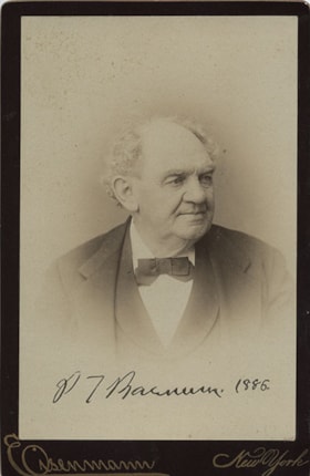
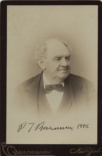
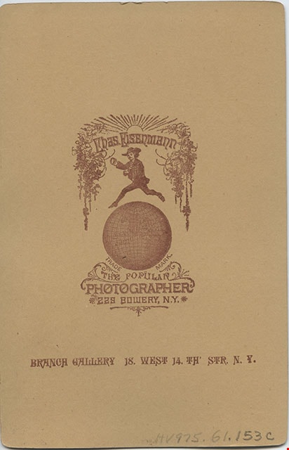
- Photograph of Phineas Taylor Barnum (1810-1891), the founder of the circus that would eventually become the Ringling Brothers and Barnum and Bailey Circus. He is 76 years of age at this time with grey hair, wearing a suit with a vest and a bow tie. Annotated or stamped on the bottom front of the ph…
- Repository
- Burnaby Village Museum
- Collection/Fonds
- Burnaby Village Museum Photograph collection
- Description Level
- Item
- Physical Description
- 1 photograph : b&w ; 14.5 x 9.5 cm mounted on cardboard 16.5 x 10.7 cm
- Scope and Content
- Photograph of Phineas Taylor Barnum (1810-1891), the founder of the circus that would eventually become the Ringling Brothers and Barnum and Bailey Circus. He is 76 years of age at this time with grey hair, wearing a suit with a vest and a bow tie. Annotated or stamped on the bottom front of the photograph: "P.T. Barnum. 1886." Printed on the bottom front of the card: "Eisenmann / New York." Printed on the back of the card, "Chas. Eisenmann / Instantaeous Photographer / Trade Mark / The Popular Photographer / 229 Bowery, N.Y. / Branch Gallery 18 West 14th Str. N.Y."
- Names
- Barnum, P.T.
- Accession Code
- HV975.61.153c
- Access Restriction
- No restrictions
- Reproduction Restriction
- No known restrictions
- Date
- 1886
- Media Type
- Photograph
- Scan Resolution
- 600
- Scan Date
- 2023-06-06
- Photographer
- Eisenmann, Charles
- Notes
- Title based on contents of photograph
- This photograph was removed from photograph album - HV975.61.153
Images
![Subdivision plans in New Westminster District Group 1 – Burnaby
, [1882-1910] thumbnail](/media/hpo/_Data/_BVM_Cartographic_Material/1977/1977_0093_0013a_001.jpg?width=280)
Subdivision plans in New Westminster District Group 1 – Burnaby
https://search.heritageburnaby.ca/link/museumdescription6982
- Repository
- Burnaby Village Museum
- Date
- [1882-1910]
- Collection/Fonds
- Burnaby Village Museum Map collection
- Description Level
- File
- Physical Description
- 4 plans : blueprint on paper mounted on 2 sides of cardboard 76 x 102 cm
- Scope and Content
- Item consists of a large board of two New Westminster District Gp 1 - subdivision plans mounted on one side and two New Westminster District Gp 1 - subdivision plans mounted on the other side. Side A: 1. Blueprint "Plan / of the / Subdivision / of / Lot 98 / G.1, N.W.D. / Scale 4 chs = 1 in. / …
- Repository
- Burnaby Village Museum
- Collection/Fonds
- Burnaby Village Museum Map collection
- Description Level
- File
- Physical Description
- 4 plans : blueprint on paper mounted on 2 sides of cardboard 76 x 102 cm
- Material Details
- Scales [between 1:1584 and 1:3168]
- Index number on edge of board reads: "13"
- Scope and Content
- Item consists of a large board of two New Westminster District Gp 1 - subdivision plans mounted on one side and two New Westminster District Gp 1 - subdivision plans mounted on the other side. Side A: 1. Blueprint "Plan / of the / Subdivision / of / Lot 98 / G.1, N.W.D. / Scale 4 chs = 1 in. / Map No 573" (Geographic location: Burnaby) 2. Blueprint "Plan / of Subdivision of / Lot 157 / Gr.1, New. West. Dist. / Scale 3 chs = 1 in. / Map No. 612". (Geographic location: Burnaby) Side B: 1. Blueprint "Plan / of Subdivision / of a Portion of / Lot 90 / Group One / New Westminster Dist. / Scale 2 chs = 1 in. / Map No. 555". Plan is signed by "Jno Strathern [sic]_P.L.S."n (Geographic location: Burnaby) 2. Blueprint "Subdivision of Lot 31, Group 1. / New Westminster District / As Amended by Order of Court / 1st Sept. 1882 and Numbered 847 / Scale 4 chs = 1in. / Map No 80" (Geographic location: Burnaby)
- Creator
- Stathern, John
- Accession Code
- HV977.93.13
- Access Restriction
- No restrictions
- Reproduction Restriction
- No known restrictions
- Date
- [1882-1910]
- Media Type
- Cartographic Material
- Historic Neighbourhood
- Alta Vista (Historic Neighbourhood)
- Planning Study Area
- Richmond Park Area
- Lakeview-Mayfield Area
- Scan Resolution
- 300
- Scale
- 72
- Notes
- Title based on contents of file
- Scale is measured in chains. (One chain equals 792 inches)
- The term "Lot" can also refer to a "District Lot”
Images
![Subdivision plans in New Westminster District Group 1 – Burnaby
, [1882-1910] thumbnail](/media/hpo/_Data/_BVM_Cartographic_Material/1977/1977_0093_0013a_001.jpg)
