Aerial photograph of Burnaby
https://search.heritageburnaby.ca/link/archivedescription84891
- Repository
- City of Burnaby Archives
- Date
- 1963
- Collection/Fonds
- Allan Amundsen collection
- Description Level
- Item
- Physical Description
- 1 photograph : b&w ; 22.5 x 22.5 cm
- Scope and Content
- Aerial photograph of Burnaby north of Lougheed Highway.
- Repository
- City of Burnaby Archives
- Date
- 1963
- Collection/Fonds
- Allan Amundsen collection
- Physical Description
- 1 photograph : b&w ; 22.5 x 22.5 cm
- Description Level
- Item
- Record No.
- 561-012
- Access Restriction
- In Archives only
- Reproduction Restriction
- No reproduction permitted
- Accession Number
- 2014-08
- Scope and Content
- Aerial photograph of Burnaby north of Lougheed Highway.
- Media Type
- Photograph
- Photographer
- Province of British Columbia
- Notes
- Title based on contents of photograph
- This photo is indentified as BC5061:117 and connects with B.C. air photograph BC5061:118 to the east
- Historic Neighbourhood
- Burnaby Lake (Historic Neighbourhood)
- Planning Study Area
- Parkcrest-Aubrey Area
- Ardingley-Sprott Area
Aerial photograph of Burnaby
https://search.heritageburnaby.ca/link/archivedescription84892
- Repository
- City of Burnaby Archives
- Date
- 1963
- Collection/Fonds
- Allan Amundsen collection
- Description Level
- Item
- Physical Description
- 1 photograph : b&w ; 22.5 x 22.5 cm
- Scope and Content
- Aerial photograph of Burnaby north of Lougheed Highway.
- Repository
- City of Burnaby Archives
- Date
- 1963
- Collection/Fonds
- Allan Amundsen collection
- Physical Description
- 1 photograph : b&w ; 22.5 x 22.5 cm
- Description Level
- Item
- Record No.
- 561-013
- Access Restriction
- In Archives only
- Reproduction Restriction
- No reproduction permitted
- Accession Number
- 2014-08
- Scope and Content
- Aerial photograph of Burnaby north of Lougheed Highway.
- Subjects
- Aerial Photographs
- Media Type
- Photograph
- Photographer
- Province of British Columbia
- Notes
- Title based on contents of photograph
- This photo is indentified as BC5061:118 and connects with B.C. air photograph BC5061:117 to the west and BC5061:119 to the east
- Historic Neighbourhood
- Burnaby Lake (Historic Neighbourhood)
- Lozells (Historic Neighbourhood)
- Planning Study Area
- Parkcrest-Aubrey Area
- Ardingley-Sprott Area
- Sperling-Broadway Area
- Government Road Area
Aerial photograph of North Burnaby
https://search.heritageburnaby.ca/link/archivedescription84881
- Repository
- City of Burnaby Archives
- Date
- 1963
- Collection/Fonds
- Allan Amundsen collection
- Description Level
- Item
- Physical Description
- 1 photograph : b&w ; 22.5 x 22.5 cm
- Scope and Content
- Aerial photograph of North Burnaby with Burrard Inlet to the north and Hastings Street, Inlet Drive, Barnet Road.
- Repository
- City of Burnaby Archives
- Date
- 1963
- Collection/Fonds
- Allan Amundsen collection
- Physical Description
- 1 photograph : b&w ; 22.5 x 22.5 cm
- Description Level
- Item
- Record No.
- 561-002
- Access Restriction
- In Archives only
- Reproduction Restriction
- No reproduction permitted
- Accession Number
- 2014-08
- Scope and Content
- Aerial photograph of North Burnaby with Burrard Inlet to the north and Hastings Street, Inlet Drive, Barnet Road.
- Media Type
- Photograph
- Photographer
- Province of British Columbia
- Notes
- Title based on contents of photograph
- This photo is indentified as BC5061:84 and connects with B.C. air photograph BC5061:85 to the west and BC5061:83 to the east
- Geographic Access
- Burrard Inlet
- Burnaby Mountain Conservation Area
- Historic Neighbourhood
- Capitol Hill (Historic Neighbourhood)
- Lochdale (Historic Neighbourhood)
- Planning Study Area
- Parkcrest-Aubrey Area
- Westridge Area
Aerial photograph of North Burnaby
https://search.heritageburnaby.ca/link/archivedescription93598
- Repository
- City of Burnaby Archives
- Date
- 1963
- Collection/Fonds
- Allan Amundsen collection
- Description Level
- Item
- Physical Description
- 1 photograph : b&w ; 22.5 x 22.5 cm
- Scope and Content
- Aerial photograph of North Burnaby with Burrard Inlet to the north and Hastings Street, Inlet Drive, Barnet Road.
- Repository
- City of Burnaby Archives
- Date
- 1963
- Collection/Fonds
- Allan Amundsen collection
- Physical Description
- 1 photograph : b&w ; 22.5 x 22.5 cm
- Description Level
- Item
- Record No.
- 561-001
- Access Restriction
- In Archives only
- Reproduction Restriction
- No reproduction permitted
- Accession Number
- 2014-08
- Scope and Content
- Aerial photograph of North Burnaby with Burrard Inlet to the north and Hastings Street, Inlet Drive, Barnet Road.
- Media Type
- Photograph
- Photographer
- Province of British Columbia
- Notes
- Title based on contents of photograph
- This photo is identified as BC5061:85
- Geographic Access
- Burrard Inlet
- Burnaby Mountain Conservation Area
- Historic Neighbourhood
- Capitol Hill (Historic Neighbourhood)
- Lochdale (Historic Neighbourhood)
- Planning Study Area
- Parkcrest-Aubrey Area
- Westridge Area

Parkcrest Plaza
https://search.heritageburnaby.ca/link/archivedescription93653
- Repository
- City of Burnaby Archives
- Date
- October 23, 1977
- Collection/Fonds
- Burnaby Public Library Contemporary Visual Archive Project
- Description Level
- Item
- Physical Description
- 1 photograph : b&w ; 12.5 x 17.5 cm
- Scope and Content
- Photograph of the Parkcrest Plaza shopping centre at Sperling and Broadway. The photograph is taken from across the parking lot and lawn, facing west. Signs for the plaza's businesses include Fresh Foods and Bank of Nova Scotia, and homes and apartment buildings are in the distance.
- Repository
- City of Burnaby Archives
- Date
- October 23, 1977
- Collection/Fonds
- Burnaby Public Library Contemporary Visual Archive Project
- Physical Description
- 1 photograph : b&w ; 12.5 x 17.5 cm
- Description Level
- Item
- Record No.
- 556-610
- Access Restriction
- No restrictions
- Reproduction Restriction
- Reproduce for fair dealing purposes only
- Accession Number
- 2017-57
- Scope and Content
- Photograph of the Parkcrest Plaza shopping centre at Sperling and Broadway. The photograph is taken from across the parking lot and lawn, facing west. Signs for the plaza's businesses include Fresh Foods and Bank of Nova Scotia, and homes and apartment buildings are in the distance.
- Subjects
- Buildings - Commercial - Grocery Stores
- Buildings - Commercial - Malls
- Buildings - Commercial - Banks
- Buildings - Commercial - Stores
- Media Type
- Photograph
- Photographer
- Chapman, Fred
- Notes
- Title taken from project information form
- Accompanied by a project information form and 1 photograph (b&w negative ; 9.5 x 12.5 cm)
- BPL no. 60
- Geographic Access
- Sperling Avenue
- Broadway
- Street Address
- 5901 Sperling Avenue
- Planning Study Area
- Parkcrest-Aubrey Area
Images

Pots & Pans
https://search.heritageburnaby.ca/link/archivedescription95124
- Repository
- City of Burnaby Archives
- Date
- April 8, 2020
- Collection/Fonds
- Burnaby Photographic Society fonds
- Description Level
- Item
- Physical Description
- 1 photograph (tiff)
- Scope and Content
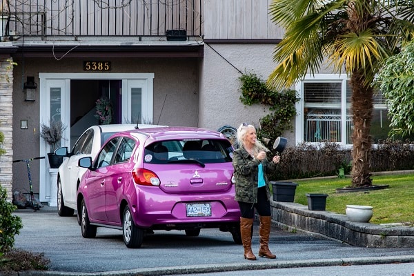
- Photograph of Burnaby resident Michelle Leone banging a pot at the end of her driveway in support of healthcare workers.
- Repository
- City of Burnaby Archives
- Date
- April 8, 2020
- Collection/Fonds
- Burnaby Photographic Society fonds
- Physical Description
- 1 photograph (tiff)
- Description Level
- Item
- Record No.
- 623-042
- Access Restriction
- No restrictions
- Reproduction Restriction
- Reproduce for fair dealing purposes only
- Accession Number
- 2020-10
- Scope and Content
- Photograph of Burnaby resident Michelle Leone banging a pot at the end of her driveway in support of healthcare workers.
- Media Type
- Photograph
- Photographer
- Jerome, Ron
- Notes
- Transcribed title
- Geographic Access
- Heathdale Court
- Street Address
- 5386 Heathdale Court
- Planning Study Area
- Parkcrest-Aubrey Area
Images