More like 'Alfred Bingham's writings - Track 2'
Narrow Results By
Subject
- Aerial Photographs 1
- Buildings - Agricultural - Barns 1
- Buildings - Commercial - Grocery Stores 5
- Buildings - Commercial - Restaurants 2
- Buildings - Commercial - Service Stations 1
- Buildings - Industrial 1
- Buildings - Religious - Churches 8
- Buildings - Residential - Apartments 4
- Buildings - Schools 3
- Construction 1
- Recreational Devices - Playgrounds 2
- Transportation - Boats 1
Person / Organization
- All Saints Anglican Church 1
- Broadview Presbyterian Church 1
- Dundonald United Church 1
- Glenwood Service Station 1
- Hawaii Cafe 1
- Hudson's Bay Company 1
- Lyndhurst Elementary School 1
- Manna Natural Foods 3
- Marine Food Basket 1
- North Road Market 1
- Riverside Elementary School 2
- St. Alban's Anglican Church 1

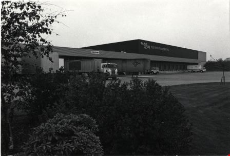
Bay Western Distribution Centre
https://search.heritageburnaby.ca/link/archivedescription79420
- Repository
- City of Burnaby Archives
- Date
- October 23, 1976
- Collection/Fonds
- Burnaby Public Library Contemporary Visual Archive Project
- Description Level
- Item
- Physical Description
- 1 photograph : b&w ; 11 x 16 cm mounted on cardboard
- Scope and Content
- Photograph shows the Bay Western Distribution Centre at 3100 Production Way in the Lake City Industrial Park. The Centre was built in 1965.
- Repository
- City of Burnaby Archives
- Date
- October 23, 1976
- Collection/Fonds
- Burnaby Public Library Contemporary Visual Archive Project
- Physical Description
- 1 photograph : b&w ; 11 x 16 cm mounted on cardboard
- Description Level
- Item
- Record No.
- 556-285
- Access Restriction
- No restrictions
- Reproduction Restriction
- Reproduce for fair dealing purposes only
- Accession Number
- 2013-13
- Scope and Content
- Photograph shows the Bay Western Distribution Centre at 3100 Production Way in the Lake City Industrial Park. The Centre was built in 1965.
- Subjects
- Buildings - Industrial
- Names
- Hudson's Bay Company
- Media Type
- Photograph
- Photographer
- Campbell, Peg
- Notes
- Scope note taken directly from BPL photograph description.
- 1 b&w copy negative : 10 x 12.5 cm accompanying
- Geographic Access
- Production Way
- Street Address
- 3100 Production Way
- Planning Study Area
- Lake City Area
Images

Manna Natural Foods
https://search.heritageburnaby.ca/link/archivedescription79117
- Repository
- City of Burnaby Archives
- Date
- September, 1976
- Collection/Fonds
- Burnaby Public Library Contemporary Visual Archive Project
- Description Level
- Item
- Physical Description
- 1 photograph : b&w ; 11 x 16 cm mounted on cardboard
- Scope and Content
- Photograph shows Manna Natural Foods at 4521 Hastings Street. The Sunshine Kitchen Restaurant is located inside the health food store.
- Repository
- City of Burnaby Archives
- Date
- September, 1976
- Collection/Fonds
- Burnaby Public Library Contemporary Visual Archive Project
- Physical Description
- 1 photograph : b&w ; 11 x 16 cm mounted on cardboard
- Description Level
- Item
- Record No.
- 556-164
- Access Restriction
- No restrictions
- Reproduction Restriction
- Reproduce for fair dealing purposes only
- Accession Number
- 2013-13
- Scope and Content
- Photograph shows Manna Natural Foods at 4521 Hastings Street. The Sunshine Kitchen Restaurant is located inside the health food store.
- Media Type
- Photograph
- Photographer
- Campbell, Peg
- Notes
- Scope note taken directly from BPL photograph description.
- 1 b&w copy negative : 10 x 12.5 cm accompanying
- Geographic Access
- Hastings Street
- Street Address
- 4521 Hastings Street
- Historic Neighbourhood
- Capitol Hill (Historic Neighbourhood)
- Planning Study Area
- Capitol Hill Area
Images


Marine Food Basket
https://search.heritageburnaby.ca/link/archivedescription79097
- Repository
- City of Burnaby Archives
- Date
- November 14, 1976
- Collection/Fonds
- Burnaby Public Library Contemporary Visual Archive Project
- Description Level
- Item
- Physical Description
- 1 photograph : b&w ; 11 x 16 cm mounted on cardboard
- Scope and Content
- Photograph shows a large truck going past the Marine Food Basket at 5886 Marine Drive and the Hawaii Cafe next door. The buildings were constructed around 1930.
- Repository
- City of Burnaby Archives
- Date
- November 14, 1976
- Collection/Fonds
- Burnaby Public Library Contemporary Visual Archive Project
- Physical Description
- 1 photograph : b&w ; 11 x 16 cm mounted on cardboard
- Description Level
- Item
- Record No.
- 556-150
- Access Restriction
- No restrictions
- Reproduction Restriction
- Reproduce for fair dealing purposes only
- Accession Number
- 2013-13
- Scope and Content
- Photograph shows a large truck going past the Marine Food Basket at 5886 Marine Drive and the Hawaii Cafe next door. The buildings were constructed around 1930.
- Media Type
- Photograph
- Photographer
- Campbell, Peg
- Notes
- Scope note taken directly from BPL photograph description.
- 1 b&w copy negative : 10 x 12.5 cm accompanying
- Geographic Access
- Marine Drive
- Street Address
- 5886 Marine Drive
- Historic Neighbourhood
- Fraser Arm (Historic Neighbourhood)
- Planning Study Area
- Big Bend Area
Images

![All Saints Church, [ca.1910] thumbnail](/media/hpo/_Data/_BVM_Cartographic_Material/2003/2003_0083_0046_001.jpg?width=280)
All Saints Church
https://search.heritageburnaby.ca/link/museumdescription11924
- Repository
- Burnaby Village Museum
- Date
- [ca.1910]
- Collection/Fonds
- Ronald G. Scobbie collection
- Description Level
- Item
- Physical Description
- 1 plan : black ink and watercol. on paper ; 30.45 x 30.5 cm
- Scope and Content
- Item consists of building insurance plan of "All Saints Church / Lot "A" BK 29 DL 98 GP1 N.W.D.". Watling Street is idenfied to the north of the church building and Royal Oak Avenue to the west.
- Repository
- Burnaby Village Museum
- Collection/Fonds
- Ronald G. Scobbie collection
- Description Level
- Item
- Physical Description
- 1 plan : black ink and watercol. on paper ; 30.45 x 30.5 cm
- Material Details
- Scale 1 inch = 20 feet
- Scope and Content
- Item consists of building insurance plan of "All Saints Church / Lot "A" BK 29 DL 98 GP1 N.W.D.". Watling Street is idenfied to the north of the church building and Royal Oak Avenue to the west.
- Subjects
- Buildings - Religious - Churches
- Accession Code
- BV003.83.46
- Access Restriction
- No restrictions
- Reproduction Restriction
- No known restrictions
- Date
- [ca.1910]
- Media Type
- Cartographic Material
- Scan Resolution
- 600
- Scan Date
- 15-Jan-2021
- Scale
- 100
- Notes
- Transcribed title
- Note in pencil on verso reads: ""All Saints Church / Lot "A" BK 29 DL 98 / Scale 1 inch = 20 feet"
- Note in balck in on verso reads: "3704"
Images
![All Saints Church, [ca.1910] thumbnail](/media/hpo/_Data/_BVM_Cartographic_Material/2003/2003_0083_0046_001.jpg)
![Anglican Church, [ca.1910] thumbnail](/media/hpo/_Data/_BVM_Cartographic_Material/2003/2003_0083_0043_001.jpg?width=280)
Anglican Church
https://search.heritageburnaby.ca/link/museumdescription11921
- Repository
- Burnaby Village Museum
- Date
- [ca.1910]
- Collection/Fonds
- Ronald G. Scobbie collection
- Description Level
- Item
- Physical Description
- 1 plan : black ink and watercol. on paper ; 30.45 x 30.5 cm
- Scope and Content
- Item consists of building insurance plan of "Anglican Church / Lot 2 BK 37 DL69, GP.1, N.W.D. (15th Ave. (Dominion) is identified to the north of Lots 1, 2 and 3).
- Repository
- Burnaby Village Museum
- Collection/Fonds
- Ronald G. Scobbie collection
- Description Level
- Item
- Physical Description
- 1 plan : black ink and watercol. on paper ; 30.45 x 30.5 cm
- Material Details
- Scale 1 inch = 20 feet
- Scope and Content
- Item consists of building insurance plan of "Anglican Church / Lot 2 BK 37 DL69, GP.1, N.W.D. (15th Ave. (Dominion) is identified to the north of Lots 1, 2 and 3).
- Subjects
- Buildings - Religious - Churches
- Accession Code
- BV003.83.43
- Access Restriction
- No restrictions
- Reproduction Restriction
- No known restrictions
- Date
- [ca.1910]
- Media Type
- Cartographic Material
- Scan Resolution
- 600
- Scan Date
- 15-Jan-2021
- Scale
- 100
- Notes
- Transcribed title
- Note in pencil on verso reads: "Anglican Church / Lot 2 Bk 37 DL69 / 1"=20' "
- Note in balck in on verso reads: "3704"
Images
![Anglican Church, [ca.1910] thumbnail](/media/hpo/_Data/_BVM_Cartographic_Material/2003/2003_0083_0043_001.jpg)

Barn near Meadow Avenue
https://search.heritageburnaby.ca/link/archivedescription79687
- Repository
- City of Burnaby Archives
- Date
- September 23, 1976
- Collection/Fonds
- Burnaby Public Library Contemporary Visual Archive Project
- Description Level
- Item
- Physical Description
- 1 photograph : b&w ; 11 x 16 cm mounted on cardboard
- Scope and Content
- Photograph shows a boat inside an old barn near Meadow Avenue and 10th Avenue.
- Repository
- City of Burnaby Archives
- Date
- September 23, 1976
- Collection/Fonds
- Burnaby Public Library Contemporary Visual Archive Project
- Physical Description
- 1 photograph : b&w ; 11 x 16 cm mounted on cardboard
- Description Level
- Item
- Record No.
- 556-383
- Access Restriction
- No restrictions
- Reproduction Restriction
- Reproduce for fair dealing purposes only
- Accession Number
- 2013-13
- Scope and Content
- Photograph shows a boat inside an old barn near Meadow Avenue and 10th Avenue.
- Media Type
- Photograph
- Photographer
- Campbell, Peg
- Notes
- Scope note taken directly from BPL photograph description.
- 1 b&w copy negative : 10 x 12.5 cm accompanying
- Geographic Access
- Meadow Avenue
- 10th Avenue
- Historic Neighbourhood
- Fraser Arm (Historic Neighbourhood)
- Planning Study Area
- Big Bend Area
Images

![Broadview Presbyterian Church, [ca.1910] thumbnail](/media/hpo/_Data/_BVM_Cartographic_Material/2003/2003_0083_0049_001.jpg?width=280)
Broadview Presbyterian Church
https://search.heritageburnaby.ca/link/museumdescription11927
- Repository
- Burnaby Village Museum
- Date
- [ca.1910]
- Collection/Fonds
- Ronald G. Scobbie collection
- Description Level
- Item
- Physical Description
- 1 plan : black ink and watercol. on paper ; 30.45 x 30.5 cm
- Scope and Content
- Item consists of building insurance plan of "Broadview Presbyterian Church / Lot 6, BK 31, DL 69 / GP1 N.W.D." . Fourteenth Avenue (Manor) is identified to the north and Douglas Ave. to the east.
- Repository
- Burnaby Village Museum
- Collection/Fonds
- Ronald G. Scobbie collection
- Description Level
- Item
- Physical Description
- 1 plan : black ink and watercol. on paper ; 30.45 x 30.5 cm
- Material Details
- Scale 1 inch = 20 feet
- Scope and Content
- Item consists of building insurance plan of "Broadview Presbyterian Church / Lot 6, BK 31, DL 69 / GP1 N.W.D." . Fourteenth Avenue (Manor) is identified to the north and Douglas Ave. to the east.
- Subjects
- Buildings - Religious - Churches
- Accession Code
- BV003.83.49
- Access Restriction
- No restrictions
- Reproduction Restriction
- No known restrictions
- Date
- [ca.1910]
- Media Type
- Cartographic Material
- Scan Resolution
- 600
- Scan Date
- 15-Jan-2021
- Scale
- 100
- Notes
- Transcribed title
- Note in pencil on verso reads: "Broadview Presbyterian Church / Lot 6, BK 31, DL 69 / 1" = 20' "
- Note in balck in on verso reads: "3704"
Images
![Broadview Presbyterian Church, [ca.1910] thumbnail](/media/hpo/_Data/_BVM_Cartographic_Material/2003/2003_0083_0049_001.jpg)
![Dundonald United Church, [ca.1910] thumbnail](/media/hpo/_Data/_BVM_Cartographic_Material/2003/2003_0083_0052_001.jpg?width=280)
Dundonald United Church
https://search.heritageburnaby.ca/link/museumdescription11930
- Repository
- Burnaby Village Museum
- Date
- [ca.1910]
- Collection/Fonds
- Ronald G. Scobbie collection
- Description Level
- Item
- Physical Description
- 1 plan : black ink and watercol. on paper ; 30.45 x 30.5 cm
- Scope and Content
- Item consists of a building insurance plan of "Dundonald United Church / Lots 9, 10 BK 28 DL 159 GP 1 / N.W.D.". Clinton Street is identified to the north of Lots nine and ten.
- Repository
- Burnaby Village Museum
- Collection/Fonds
- Ronald G. Scobbie collection
- Description Level
- Item
- Physical Description
- 1 plan : black ink and watercol. on paper ; 30.45 x 30.5 cm
- Material Details
- Scale 1 inch = 20 feet
- Scope and Content
- Item consists of a building insurance plan of "Dundonald United Church / Lots 9, 10 BK 28 DL 159 GP 1 / N.W.D.". Clinton Street is identified to the north of Lots nine and ten.
- Subjects
- Buildings - Religious - Churches
- Names
- Dundonald United Church
- Accession Code
- BV003.83.52
- Access Restriction
- No restrictions
- Reproduction Restriction
- No known restrictions
- Date
- [ca.1910]
- Media Type
- Cartographic Material
- Scan Resolution
- 600
- Scan Date
- 15-Jan-2021
- Scale
- 100
- Notes
- Transcribed title
- Note in pencil on verso reads: "_ _Church / Lots 9 & 10 BK 28 DL 159 / 1" = 20' "
- Note in black ink on verso reads: "3704"
Images
![Dundonald United Church, [ca.1910] thumbnail](/media/hpo/_Data/_BVM_Cartographic_Material/2003/2003_0083_0052_001.jpg)
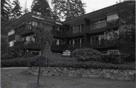
Falling Waters Apartment Building
https://search.heritageburnaby.ca/link/archivedescription79020
- Repository
- City of Burnaby Archives
- Date
- October 23, 1976
- Collection/Fonds
- Burnaby Public Library Contemporary Visual Archive Project
- Description Level
- Item
- Physical Description
- 1 photograph : b&w ; 11 x 16 cm mounted on cardboard
- Scope and Content
- Photograph shows the Falling Waters apartment building. Located at 9444 Cameron Street, this apartment was designed and built by Bob Rapske in 1968 and - at the time of the photograph - was owned by Walnut Enterprises.
- Repository
- City of Burnaby Archives
- Date
- October 23, 1976
- Collection/Fonds
- Burnaby Public Library Contemporary Visual Archive Project
- Physical Description
- 1 photograph : b&w ; 11 x 16 cm mounted on cardboard
- Description Level
- Item
- Record No.
- 556-095
- Access Restriction
- No restrictions
- Reproduction Restriction
- Reproduce for fair dealing purposes only
- Accession Number
- 2013-13
- Scope and Content
- Photograph shows the Falling Waters apartment building. Located at 9444 Cameron Street, this apartment was designed and built by Bob Rapske in 1968 and - at the time of the photograph - was owned by Walnut Enterprises.
- Subjects
- Buildings - Residential - Apartments
- Media Type
- Photograph
- Photographer
- Campbell, Peg
- Notes
- Scope note taken directly from BPL photograph description.
- 1 b&w copy negative : 10 x 12.5 cm accompanying
- Geographic Access
- Cameron Street
- Street Address
- 9444 Cameron Street
- Historic Neighbourhood
- Burquitlam (Historic Neighbourhood)
- Planning Study Area
- Cameron Area
Images

Falling Waters Apartment Building
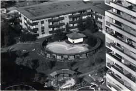
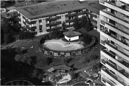
https://search.heritageburnaby.ca/link/archivedescription79022
- Repository
- City of Burnaby Archives
- Date
- September 27, 1976
- Collection/Fonds
- Burnaby Public Library Contemporary Visual Archive Project
- Description Level
- Item
- Physical Description
- 1 photograph : b&w ; 11 x 16 cm mounted on cardboard
- Scope and Content
- Photograph shows the view from Salish Court Tower West of the swimming pool behind the Falling Waters apartment building on Cameron Street.
- Repository
- City of Burnaby Archives
- Date
- September 27, 1976
- Collection/Fonds
- Burnaby Public Library Contemporary Visual Archive Project
- Physical Description
- 1 photograph : b&w ; 11 x 16 cm mounted on cardboard
- Description Level
- Item
- Record No.
- 556-096
- Access Restriction
- No restrictions
- Reproduction Restriction
- Reproduce for fair dealing purposes only
- Accession Number
- 2013-13
- Scope and Content
- Photograph shows the view from Salish Court Tower West of the swimming pool behind the Falling Waters apartment building on Cameron Street.
- Subjects
- Buildings - Residential - Apartments
- Media Type
- Photograph
- Photographer
- Campbell, Peg
- Notes
- Scope note taken directly from BPL photograph description.
- 1 b&w copy negative : 10 x 12.5 cm accompanying
- Geographic Access
- Cameron Street
- Street Address
- 9444 Cameron Street
- Historic Neighbourhood
- Burquitlam (Historic Neighbourhood)
- Planning Study Area
- Cameron Area
Images

Glenwood Service Station
https://search.heritageburnaby.ca/link/archivedescription79264
- Repository
- City of Burnaby Archives
- Date
- November 14, 1976
- Collection/Fonds
- Burnaby Public Library Contemporary Visual Archive Project
- Description Level
- Item
- Physical Description
- 1 photograph : b&w ; 11 x 16 cm mounted on cardboard
- Scope and Content
- Photograph shows a view from Gilley Avenue of the Glenwood Service Station at 5894 Marine Drive.
- Repository
- City of Burnaby Archives
- Date
- November 14, 1976
- Collection/Fonds
- Burnaby Public Library Contemporary Visual Archive Project
- Physical Description
- 1 photograph : b&w ; 11 x 16 cm mounted on cardboard
- Description Level
- Item
- Record No.
- 556-228
- Access Restriction
- No restrictions
- Reproduction Restriction
- Reproduce for fair dealing purposes only
- Accession Number
- 2013-13
- Scope and Content
- Photograph shows a view from Gilley Avenue of the Glenwood Service Station at 5894 Marine Drive.
- Names
- Glenwood Service Station
- Media Type
- Photograph
- Photographer
- Campbell, Peg
- Notes
- Scope note taken directly from BPL photograph description.
- 1 b&w copy negative : 10 x 12.5 cm accompanying
- Geographic Access
- Marine Drive
- Street Address
- 5894 Marine Drive
- Historic Neighbourhood
- Fraser Arm (Historic Neighbourhood)
- Planning Study Area
- Big Bend Area
Images

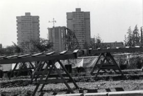
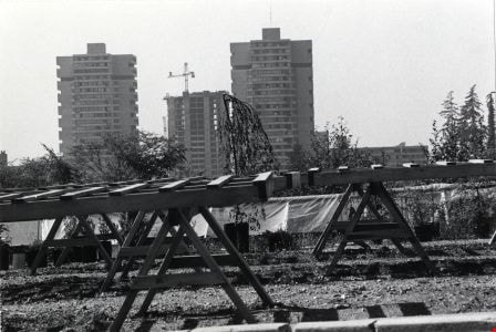
High-rise on Salish Court
https://search.heritageburnaby.ca/link/archivedescription79037
- Repository
- City of Burnaby Archives
- Date
- September 20, 1976
- Collection/Fonds
- Burnaby Public Library Contemporary Visual Archive Project
- Description Level
- Item
- Physical Description
- 1 photograph : b&w ; 11 x 16 cm mounted on cardboard
- Scope and Content
- Photograph shows a view of high-rise apartment buildings on Salish Court, looking west from the Blue Mountain Florist Shop on North Road.
- Repository
- City of Burnaby Archives
- Date
- September 20, 1976
- Collection/Fonds
- Burnaby Public Library Contemporary Visual Archive Project
- Physical Description
- 1 photograph : b&w ; 11 x 16 cm mounted on cardboard
- Description Level
- Item
- Record No.
- 556-106
- Access Restriction
- No restrictions
- Reproduction Restriction
- Reproduce for fair dealing purposes only
- Accession Number
- 2013-13
- Scope and Content
- Photograph shows a view of high-rise apartment buildings on Salish Court, looking west from the Blue Mountain Florist Shop on North Road.
- Media Type
- Photograph
- Photographer
- Campbell, Peg
- Notes
- Scope note taken directly from BPL photograph description.
- 1 b&w copy negative : 10 x 12.5 cm accompanying
- Geographic Access
- Salish Court
- Historic Neighbourhood
- Burquitlam (Historic Neighbourhood)
- Planning Study Area
- Cameron Area
Images

Lougheed Highway
https://search.heritageburnaby.ca/link/archivedescription79939
- Repository
- City of Burnaby Archives
- Date
- September 27, 1976
- Collection/Fonds
- Burnaby Public Library Contemporary Visual Archive Project
- Description Level
- Item
- Physical Description
- 1 photograph : b&w ; 11 x 16 cm mounted on cardboard
- Scope and Content
- Photograph shows an aerial view of Lougheed Highway looking southeast from Salish Court Tower west.
- Repository
- City of Burnaby Archives
- Date
- September 27, 1976
- Collection/Fonds
- Burnaby Public Library Contemporary Visual Archive Project
- Physical Description
- 1 photograph : b&w ; 11 x 16 cm mounted on cardboard
- Description Level
- Item
- Record No.
- 556-510
- Access Restriction
- No restrictions
- Reproduction Restriction
- Reproduce for fair dealing purposes only
- Accession Number
- 2013-13
- Scope and Content
- Photograph shows an aerial view of Lougheed Highway looking southeast from Salish Court Tower west.
- Media Type
- Photograph
- Photographer
- Campbell, Peg
- Notes
- Scope note taken directly from BPL photograph description.
- 1 b&w copy negative : 10 x 12.5 cm accompanying
- Geographic Access
- Lougheed Highway
- Historic Neighbourhood
- Burquitlam (Historic Neighbourhood)
- Planning Study Area
- Cameron Area
Images

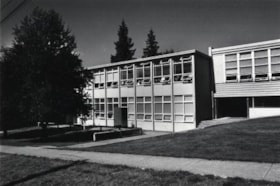
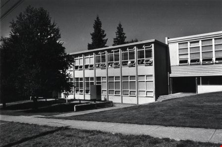
Lyndhurst Elementary School
https://search.heritageburnaby.ca/link/archivedescription79614
- Repository
- City of Burnaby Archives
- Date
- September 20, 1976
- Collection/Fonds
- Burnaby Public Library Contemporary Visual Archive Project
- Description Level
- Item
- Physical Description
- 1 photograph : b&w ; 11 x 16 cm mounted on cardboard
- Scope and Content
- Photograph shows Lyndhurst Elementary School at 9847 Lyndhurst Street.
- Repository
- City of Burnaby Archives
- Date
- September 20, 1976
- Collection/Fonds
- Burnaby Public Library Contemporary Visual Archive Project
- Physical Description
- 1 photograph : b&w ; 11 x 16 cm mounted on cardboard
- Description Level
- Item
- Record No.
- 556-355
- Access Restriction
- No restrictions
- Reproduction Restriction
- Reproduce for fair dealing purposes only
- Accession Number
- 2013-13
- Scope and Content
- Photograph shows Lyndhurst Elementary School at 9847 Lyndhurst Street.
- Subjects
- Buildings - Schools
- Media Type
- Photograph
- Photographer
- Campbell, Peg
- Notes
- Scope note taken directly from BPL photograph description.
- 1 b&w copy negative : 10 x 12.5 cm accompanying
- Geographic Access
- Lyndhurst Street
- Street Address
- 9847 Lyndhurst Street
- Historic Neighbourhood
- Burquitlam (Historic Neighbourhood)
- Planning Study Area
- Lyndhurst Area
Images
Manna Natural Foods
https://search.heritageburnaby.ca/link/archivedescription79119
- Repository
- City of Burnaby Archives
- Date
- September, 1976
- Collection/Fonds
- Burnaby Public Library Contemporary Visual Archive Project
- Description Level
- Item
- Physical Description
- 1 photograph : b&w ; 11 x 16 cm mounted on cardboard
- Scope and Content
- Photograph shows customers inside Manna Natural Foods at 4521 Hastings Street.
- Repository
- City of Burnaby Archives
- Date
- September, 1976
- Collection/Fonds
- Burnaby Public Library Contemporary Visual Archive Project
- Physical Description
- 1 photograph : b&w ; 11 x 16 cm mounted on cardboard
- Description Level
- Item
- Record No.
- 556-165
- Access Restriction
- No restrictions
- Reproduction Restriction
- Reproduce for fair dealing purposes only
- Accession Number
- 2013-13
- Scope and Content
- Photograph shows customers inside Manna Natural Foods at 4521 Hastings Street.
- Names
- Manna Natural Foods
- Media Type
- Photograph
- Photographer
- Campbell, Peg
- Notes
- Scope note taken directly from BPL photograph description.
- 1 b&w copy negative : 10 x 12.5 cm accompanying
- Geographic Access
- Hastings Street
- Street Address
- 4521 Hastings Street
- Historic Neighbourhood
- Capitol Hill (Historic Neighbourhood)
- Planning Study Area
- Capitol Hill Area
Images

Manna Natural Foods
https://search.heritageburnaby.ca/link/archivedescription79120
- Repository
- City of Burnaby Archives
- Date
- September, 1976
- Collection/Fonds
- Burnaby Public Library Contemporary Visual Archive Project
- Description Level
- Item
- Physical Description
- 1 photograph : b&w ; 11 x 16 cm mounted on cardboard
- Scope and Content
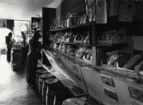
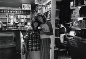
- Photograph shows two employees inside Manna Natural Foods in front of the herb counter.
- Repository
- City of Burnaby Archives
- Date
- September, 1976
- Collection/Fonds
- Burnaby Public Library Contemporary Visual Archive Project
- Physical Description
- 1 photograph : b&w ; 11 x 16 cm mounted on cardboard
- Description Level
- Item
- Record No.
- 556-166
- Access Restriction
- No restrictions
- Reproduction Restriction
- Reproduce for fair dealing purposes only
- Accession Number
- 2013-13
- Scope and Content
- Photograph shows two employees inside Manna Natural Foods in front of the herb counter.
- Names
- Manna Natural Foods
- Media Type
- Photograph
- Photographer
- Campbell, Peg
- Notes
- Scope note taken directly from BPL photograph description.
- 1 b&w copy negative : 10 x 12.5 cm accompanying
- Geographic Access
- Hastings Street
- Street Address
- 4521 Hastings Street
- Historic Neighbourhood
- Capitol Hill (Historic Neighbourhood)
- Planning Study Area
- Capitol Hill Area
Images

North Road Market
https://search.heritageburnaby.ca/link/archivedescription79108
- Repository
- City of Burnaby Archives
- Date
- September 20, 1976
- Collection/Fonds
- Burnaby Public Library Contemporary Visual Archive Project
- Description Level
- Item
- Physical Description
- 1 photograph : b&w ; 11 x 16 cm mounted on cardboard
- Scope and Content
- Photograph shows the North Road Market located at 3569 North Road.
- Repository
- City of Burnaby Archives
- Date
- September 20, 1976
- Collection/Fonds
- Burnaby Public Library Contemporary Visual Archive Project
- Physical Description
- 1 photograph : b&w ; 11 x 16 cm mounted on cardboard
- Description Level
- Item
- Record No.
- 556-157
- Access Restriction
- No restrictions
- Reproduction Restriction
- Reproduce for fair dealing purposes only
- Accession Number
- 2013-13
- Scope and Content
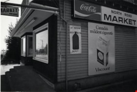
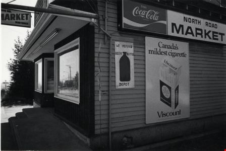
- Photograph shows the North Road Market located at 3569 North Road.
- Names
- North Road Market
- Media Type
- Photograph
- Photographer
- Campbell, Peg
- Notes
- Scope note taken directly from BPL photograph description.
- 1 b&w copy negative : 10 x 12.5 cm accompanying
- Geographic Access
- North Road
- Street Address
- 3569 North Road
- Historic Neighbourhood
- Burquitlam (Historic Neighbourhood)
- Planning Study Area
- Cameron Area
Images
Riverside Elementary School
https://search.heritageburnaby.ca/link/archivedescription79616
- Repository
- City of Burnaby Archives
- Date
- September 23, 1976
- Collection/Fonds
- Burnaby Public Library Contemporary Visual Archive Project
- Description Level
- Item
- Physical Description
- 1 photograph : b&w ; 11 x 16 cm mounted on cardboard
- Scope and Content
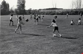
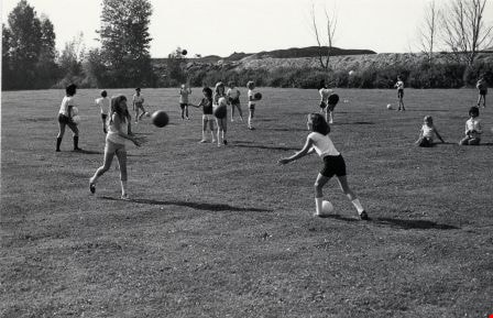
- Photograph shows children playing at Riverside Elementary School at 7855 Meadow Avenue.
- Repository
- City of Burnaby Archives
- Date
- September 23, 1976
- Collection/Fonds
- Burnaby Public Library Contemporary Visual Archive Project
- Physical Description
- 1 photograph : b&w ; 11 x 16 cm mounted on cardboard
- Description Level
- Item
- Record No.
- 556-357
- Access Restriction
- No restrictions
- Reproduction Restriction
- Reproduce for fair dealing purposes only
- Accession Number
- 2013-13
- Scope and Content
- Photograph shows children playing at Riverside Elementary School at 7855 Meadow Avenue.
- Media Type
- Photograph
- Photographer
- Campbell, Peg
- Notes
- Scope note taken directly from BPL photograph description.
- 1 b&w copy negative : 10 x 12.5 cm accompanying
- Geographic Access
- Meadow Avenue
- Street Address
- 7855 Meadow Avenue
- Historic Neighbourhood
- Fraser Arm (Historic Neighbourhood)
- Planning Study Area
- Big Bend Area
Images
Riverside Elementary School
https://search.heritageburnaby.ca/link/archivedescription79617
- Repository
- City of Burnaby Archives
- Date
- September 23, 1976
- Collection/Fonds
- Burnaby Public Library Contemporary Visual Archive Project
- Description Level
- Item
- Physical Description
- 1 photograph : b&w ; 11 x 16 cm mounted on cardboard
- Scope and Content
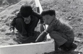
- Photograph shows children playing in a sandbox on the grounds of Riverside Elementary School at 7855 Meadow Avenue.
- Repository
- City of Burnaby Archives
- Date
- September 23, 1976
- Collection/Fonds
- Burnaby Public Library Contemporary Visual Archive Project
- Physical Description
- 1 photograph : b&w ; 11 x 16 cm mounted on cardboard
- Description Level
- Item
- Record No.
- 556-358
- Access Restriction
- No restrictions
- Reproduction Restriction
- Reproduce for fair dealing purposes only
- Accession Number
- 2013-13
- Scope and Content
- Photograph shows children playing in a sandbox on the grounds of Riverside Elementary School at 7855 Meadow Avenue.
- Media Type
- Photograph
- Photographer
- Campbell, Peg
- Notes
- Scope note taken directly from BPL photograph description.
- 1 b&w copy negative : 10 x 12.5 cm accompanying
- Geographic Access
- Meadow Avenue
- Street Address
- 7855 Meadow Avenue
- Historic Neighbourhood
- Fraser Arm (Historic Neighbourhood)
- Planning Study Area
- Big Bend Area
Images

![St. Albans the Martyr, [ca.1910] thumbnail](/media/hpo/_Data/_BVM_Cartographic_Material/2003/2003_0083_0048_001.jpg?width=280)
St. Albans the Martyr
https://search.heritageburnaby.ca/link/museumdescription11926
- Repository
- Burnaby Village Museum
- Date
- [ca.1910]
- Collection/Fonds
- Ronald G. Scobbie collection
- Description Level
- Item
- Physical Description
- 1 plan : black ink and watercol. on paper ; 30.45 x 30.5 cm
- Scope and Content
- Item consists of building insurance plan of "St. Albans the Martyr / Lots 45 & 46 North Part DL 28 / GP1 N.W.D." Edmonds Street is to the north, Douglas Road to the west and 19th Avenue to the south.
- Repository
- Burnaby Village Museum
- Collection/Fonds
- Ronald G. Scobbie collection
- Description Level
- Item
- Physical Description
- 1 plan : black ink and watercol. on paper ; 30.45 x 30.5 cm
- Material Details
- Scale 1 inch = 40 feet
- Scope and Content
- Item consists of building insurance plan of "St. Albans the Martyr / Lots 45 & 46 North Part DL 28 / GP1 N.W.D." Edmonds Street is to the north, Douglas Road to the west and 19th Avenue to the south.
- Subjects
- Buildings - Religious - Churches
- Accession Code
- BV003.83.48
- Access Restriction
- No restrictions
- Reproduction Restriction
- No known restrictions
- Date
- [ca.1910]
- Media Type
- Cartographic Material
- Scan Resolution
- 600
- Scan Date
- 15-Jan-2021
- Scale
- 100
- Notes
- Transcribed title
- Note in pencil on verso reads: "St. Albans the Martyr / Lots 45 & 46 North Part DL 28 / 1" = 40' "
- Note in balck in on verso reads: "3704"
Images
![St. Albans the Martyr, [ca.1910] thumbnail](/media/hpo/_Data/_BVM_Cartographic_Material/2003/2003_0083_0048_001.jpg)