Narrow Results By
Creator
- Bartel, Mario 23
- British Columbia Underwriters' Association 3
- Burnett, Geoffrey K.
- Burnett & McGugan, Engineers and Surveyors 1
- Cheung, Nakita 2
- Cooksley, William Thomas 3
- Disney, John Harold "Jack" 4
- Garden, Hermon and Burwell 1
- Hodge, Craig
- Jones, Charles Spurgeon "Chuck" 1
- King, Basil 2
- Leibly & Blumer Realty Co. Incorporated 1

Armstrong Street School site
https://search.heritageburnaby.ca/link/museumdescription11133
- Repository
- Burnaby Village Museum
- Date
- 1915
- Collection/Fonds
- Ronald G. Scobbie collection
- Description Level
- Item
- Physical Description
- 1 survey plan : blueprint on paper ; 56 x 54 cm
- Scope and Content
- Survey plan of "Armstrong Street School Site / Burnaby Municipality" "Being a 2 acre portion of Lot 13 Group 1, & according to map 1722 which shows this as Lot E. Block 2 of subdivision of a portion, of Lot 13, Group 1, New Westminster District".
- Repository
- Burnaby Village Museum
- Collection/Fonds
- Ronald G. Scobbie collection
- Description Level
- Item
- Physical Description
- 1 survey plan : blueprint on paper ; 56 x 54 cm
- Material Details
- Scale 40 feet = 1 inch
- Scope and Content
- Survey plan of "Armstrong Street School Site / Burnaby Municipality" "Being a 2 acre portion of Lot 13 Group 1, & according to map 1722 which shows this as Lot E. Block 2 of subdivision of a portion, of Lot 13, Group 1, New Westminster District".
- Creator
- Burnett, Geoffrey K.
- Subjects
- Buildings - Schools
- Names
- Armstrong Avenue School
- Responsibility
- Burnett & McGugan, Engineers and Surveyors
- Geographic Access
- Armstrong Avenue
- Street Address
- 8757 Armstrong Avenue
- Accession Code
- BV003.83.12
- Access Restriction
- No restrictions
- Reproduction Restriction
- No known restrictions
- Date
- 1915
- Media Type
- Cartographic Material
- Historic Neighbourhood
- East Burnaby (Historic Neighbourhood)
- Planning Study Area
- Cariboo-Armstrong Area
- Scan Resolution
- 440
- Scan Date
- 22-Dec-2020
- Scale
- 100
- Notes
- Title based on contents of plan
- Note in black ink on verso of plan reads: "1746"
- Oath on plan reads: "I, Geoffrey K. Burnett...and did personally superintend the survey represented..." "Completed on the 18th day of March 1915"; signed by Geoffrey K. Burnett and notarized by "K.A. Eastman", sworn "...19th day of April 1915"; "Burnett and McGugan., B.C. Land Surveyors. Etc.. New Westminster, B.C.."
Zoomable Images


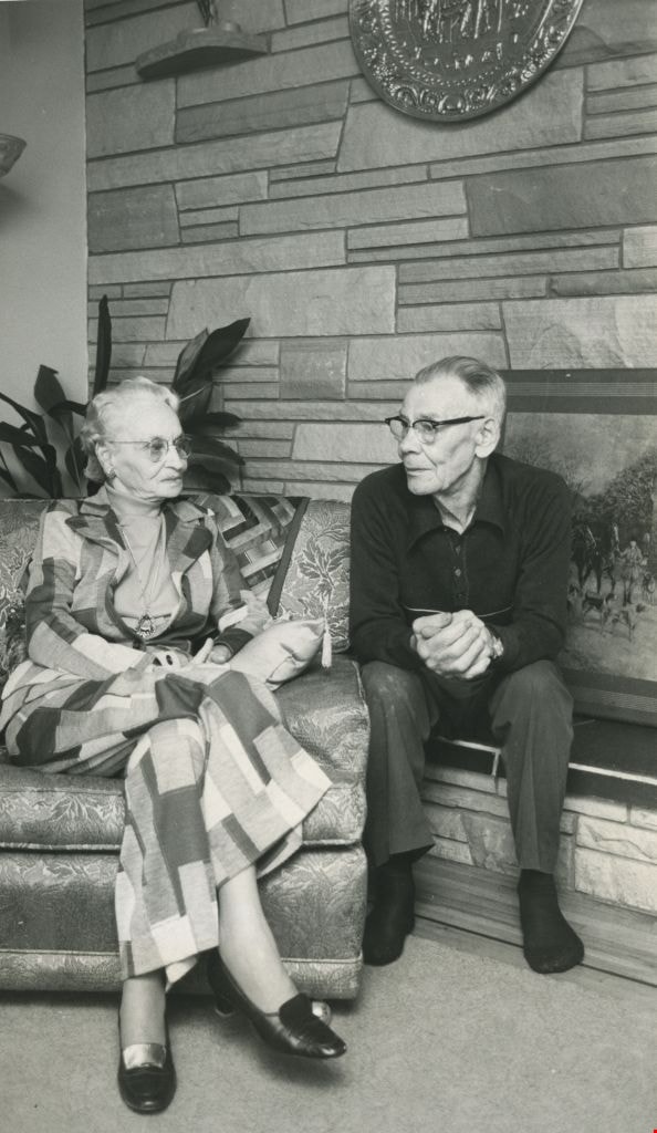
Ceina and Bill Griston
https://search.heritageburnaby.ca/link/archivedescription45259
- Repository
- City of Burnaby Archives
- Date
- 1976, published May 6, 1976
- Collection/Fonds
- Columbian Newspaper collection
- Description Level
- Item
- Physical Description
- 1 photograph : b&w ; 24 x 14 cm
- Scope and Content
- Photograph of Ceina and Bill Griston sitting by the fireplace of their Burnaby home, when Ceina Griston was 67 years old and so active in volunteer work that her husband, then 75 years old, acted as her secretary; taking phone messages and keeping track of her schedule for her.
- Repository
- City of Burnaby Archives
- Date
- 1976, published May 6, 1976
- Collection/Fonds
- Columbian Newspaper collection
- Physical Description
- 1 photograph : b&w ; 24 x 14 cm
- Description Level
- Item
- Record No.
- 480-155
- Access Restriction
- No restrictions
- Reproduction Restriction
- No restrictions
- Accession Number
- 2003-02
- Scope and Content
- Photograph of Ceina and Bill Griston sitting by the fireplace of their Burnaby home, when Ceina Griston was 67 years old and so active in volunteer work that her husband, then 75 years old, acted as her secretary; taking phone messages and keeping track of her schedule for her.
- Subjects
- Persons - Volunteers
- Names
- Griston, Ceina
- Griston, Bill
- Media Type
- Photograph
- Photographer
- Hodge, Craig
- Notes
- Title based on contents of photograph
- Geographic Access
- Newcombe Street
- Street Address
- 7623 Newcombe Street
- Historic Neighbourhood
- East Burnaby (Historic Neighbourhood)
- Planning Study Area
- Second Street Area
Images

Plan of Subdivision of Block F Lot 1, D.L. 25 Group 1
https://search.heritageburnaby.ca/link/museumdescription18808
- Repository
- Burnaby Village Museum
- Date
- 17 Apr. 1912
- Collection/Fonds
- Love family fonds
- Description Level
- Item
- Physical Description
- 1 plan : black and red ink on linen ; 36 x 28.5 cm
- Scope and Content
- Item consists of Plan of Subdivision of Block F Lot 1, D.L. 25 Group 1 New Westminster District created by Provincial Land Surveyor Geoffrey K. Burnett.
- Repository
- Burnaby Village Museum
- Collection/Fonds
- Love family fonds
- Description Level
- Item
- Physical Description
- 1 plan : black and red ink on linen ; 36 x 28.5 cm
- Material Details
- Scale [1:1200]
- Scope and Content
- Item consists of Plan of Subdivision of Block F Lot 1, D.L. 25 Group 1 New Westminster District created by Provincial Land Surveyor Geoffrey K. Burnett.
- Creator
- Burnett, Geoffrey K.
- Names
- Burnett, Geoffrey K.
- Geographic Access
- Cumberland Street
- Accession Code
- BV992.26.28
- Access Restriction
- No restrictions
- Reproduction Restriction
- No known restrictions
- Date
- 17 Apr. 1912
- Media Type
- Cartographic Material
- Historic Neighbourhood
- East Burnaby (Historic Neighbourhood)
- Planning Study Area
- Cariboo-Armstrong Area
- Scan Resolution
- 600
- Scan Date
- 2022-07-11
- Scale
- 100
- Notes
- Title based on contents of item
- Scale is measured "100 FT = 1 INCH"
- "PLAN OF SUBDIVISION OF BLOCK "F" OF LOT 1, D.L. 25 GROUP 1. NEW WESTMINSTER DISTRICT"; Wright St., Sixth Ave., Fifth Ave., Cumberland St., L.1-8, 11-16; signature of Jesse Love, owner, witness S.P. King?; Geoffrey K. Burnett, P.L.S.; Fred A. Macpherson, Municipal Clerk, April 17, 1912; taxes paid to Dec. 31 1911, signed April 17 1912 by W.H. Griffin, collector"
Images


Plan of Subdivision of Block F Lot 1, D.L. 25 Group 1
https://search.heritageburnaby.ca/link/museumdescription18809
- Repository
- Burnaby Village Museum
- Date
- 17 Apr. 1912
- Collection/Fonds
- Love family fonds
- Description Level
- Item
- Physical Description
- 1 plan : black and red ink on linen ; 36 x 28.5 cm
- Scope and Content
- Item consists of Plan of Subdivision of Block F Lot 1, D.L. 25 Group 1 New Westminster District created by Provincial Land Surveyor Geoffrey K. Burnett.
- Repository
- Burnaby Village Museum
- Collection/Fonds
- Love family fonds
- Description Level
- Item
- Physical Description
- 1 plan : black and red ink on linen ; 36 x 28.5 cm
- Material Details
- Scale [1:1200]
- Scope and Content
- Item consists of Plan of Subdivision of Block F Lot 1, D.L. 25 Group 1 New Westminster District created by Provincial Land Surveyor Geoffrey K. Burnett.
- Creator
- Burnett, Geoffrey K.
- Names
- Burnett, Geoffrey K.
- Geographic Access
- Cumberland Street
- Accession Code
- BV992.26.29
- Access Restriction
- No restrictions
- Reproduction Restriction
- No known restrictions
- Date
- 17 Apr. 1912
- Media Type
- Cartographic Material
- Historic Neighbourhood
- East Burnaby (Historic Neighbourhood)
- Planning Study Area
- Cariboo-Armstrong Area
- Scan Resolution
- 600
- Scan Date
- 2022-07-11
- Scale
- 100
- Notes
- Title based on contents of item
- Scale is measured "100 FT = 1 INCH"
- "PLAN OF SUBDIVISION OF BLOCK "F" OF LOT 1, D.L. 25 GROUP 1. NEW WESTMINSTER DISTRICT"; Wright St., Sixth Ave., Fifth Ave., Cumberland St., L.1-8, 11-16; signature of Jesse Love, owner, witness S.P. King?; Geoffrey K. Burnett, P.L.S.; Fred A. Macpherson, Municipal Clerk, April 17, 1912; taxes paid to Dec. 31 1911, signed April 17 1912 by W.H. Griffin, collector"
Images
