Narrow Results By
Creator
- British Columbia Hydro and Power Authority 1
- Burnaby Centennial '71 Committee 1
- Burnaby Parks and Recreation Commission
- Burnaby Village Museum 10
- Burnett, David H.
- Burnett & McGugan, Engineers and Surveyors 1
- Buzza, Joy 4
- Century Park Museum Association 9
- Charles Torrence Limited 1
- City of Burnaby 1
- Copan, Donald Angus "Don" 1
- Copan, Donald (Don) 1
brochure
https://search.heritageburnaby.ca/link/museumartifact91373
- Repository
- Burnaby Village Museum
- Accession Code
- BV020.5.2124
- Description
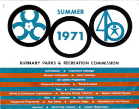
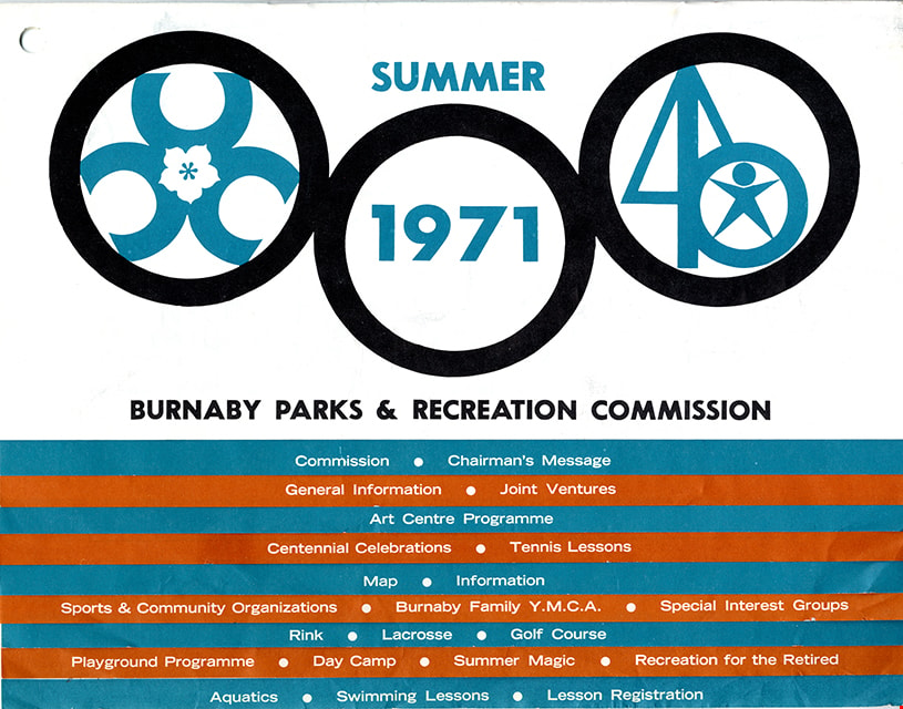
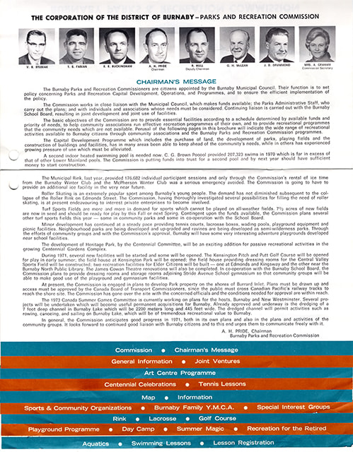
- Burnaby Parks and Recreation brochure; five pages folded and stapled offset to create 10 tabs in aqua blue and orange separating sections by subject. Title on cover page reads "SUMMER 1971" with three rings linked together; B.C. Centennial logo with dogwood flower inside left circle; "1971" inside centre circle and a sports logo inside circle on right; text beneath reads "BURNBY PARKS & RECREATION COMMISSION". Tabbed sections in aqua blue and orange are titled "Commission _ Chairman's Message / General Information_Joint Ventures / Art Centre Programme / Centennial Celebrations_Tennis Lessons / Map_Information / Sports & Community Organizations_Burnaby Family Y.M.C.A._Special Interest Groups / Rink_Lacrosse_Golf Course / Playground Programme_Day Camp_Summer Magic _Recreation for the Retired / Aquatics_Swimming Lessons_Lesson Registration". Verso of Brochure includes information "SWIMMING LESSON REGISTRATION" and a "SWIMMING LESSON REGISTRATION CARD"
- Object History
- Brochure created by the Corporation of the District of Burnaby Parks and Recreation Commission and made available to Burnaby citizens during the Centennial 1971 festivities in Burnaby.
- Category
- 08. Communication Artifacts
- Classification
- Documentary Artifacts - - Other Documents
- Object Term
- Brochure
- Marks/Labels
- invitation has marks from being handled
- Colour
- Blue
- Orange
- White
- Black
- Measurements
- Length: 28 cm
- Width: 22 cm
- Country Made
- Canada
- Province Made
- British Columbia
- Site/City Made
- Burnaby
- Publication Date
- 1971
- Subjects
- Sports
- Celebrations - Centennials
Images

Ronald G. Scobbie collection
https://search.heritageburnaby.ca/link/museumdescription11914
- Repository
- Burnaby Village Museum
- Date
- [1890]-1932
- Collection/Fonds
- Ronald G. Scobbie collection
- Description Level
- Fonds
- Physical Description
- 55 plans + 2 architectural drawings + 1 map + graphic materials + 3 cm of textual records
- Scope and Content
- Fonds consists of survey and subdivision plans, a map and records created by Provincial Land Surveyors Albert J. Hill and Geoffrey K. Burnett and Donald Johnson McGugan and collected by Ronald G. Scobbie. Records include subdivision and survey plans in New Westminster District Group 1 including Dis…
- Repository
- Burnaby Village Museum
- Collection/Fonds
- Ronald G. Scobbie collection
- Description Level
- Fonds
- Physical Description
- 55 plans + 2 architectural drawings + 1 map + graphic materials + 3 cm of textual records
- Scope and Content
- Fonds consists of survey and subdivision plans, a map and records created by Provincial Land Surveyors Albert J. Hill and Geoffrey K. Burnett and Donald Johnson McGugan and collected by Ronald G. Scobbie. Records include subdivision and survey plans in New Westminster District Group 1 including District Lots in Burnaby along with various school sites and church plans; surveying records regarding North Road and a map of the Burnaby Municipality. Fonds is arranged into series: 1) Subdivision and survey plans series 2) School and church plans series 3) Map series
- History
- Ronald G. Scobbie was born in Scotland. After graduating from high school, he worked in the mines of Scotland which led to a career as a land surveyor. Ron immigrated to Canada in 1965 and settled in North Vancouver. In 1967 he became a partner in the surveying company of Hunter, Crockford & Scobbie in New Westminster, eventually owning it under the title Scobbie and Associates between 1980 and 1995. Ron sold the business in 1995 and retired as a BC Land Surveyor in December 2003. Ron was an active member of the B.C. Land Surveyors Association and an avid collector of surveying equipment and maps and plans that document the history of surveying in British Columbia. Upon retirement, Ron donated many historical maps and plans to various repositories located in different geographical regions throughout B.C.
- Scobbie & Associates land surveying company dates back to 1890 when Albert J. Hill first established his practice as a land surveyor in New Westminster. The company went through a series of Surveyors (owners) between 1890 and 1995:
- Albert James Hill (A.J. Hill) [1890] to 1912
- Hill & Burnett 1911 to 1912
- Geoffrey K. Burnett 1912
- Burnett & McGugan 1912 to 1947
- Burnett, McGugan & Hunter 1947 to 1959
- Burnett, Hunter & Douglas 1959 to 1960
- Hunter, Douglas & Crockford 1960 to 1964
- Hunter, Crockford & Associates 1964 to 1965
- Hunter, Crockford & Aplin 1965 to 1967
- Hunter, Crockford & Scobbie 1967 to 1973
- Crockford, Scobbie & Associates 1973-1980
- Scobbie & Associates 1980 to 1995
- Responsibility
- Scobbie, Ronald G.
- Accession Code
- HV984.57
- BV003.83
- Access Restriction
- No restrictions
- Reproduction Restriction
- No known restrictions
- Date
- [1890]-1932
- Related Material
- For other survey and subdivision plans created by land surveyors Albert J. Hill, Geoffery K. Burnett and Donald J. McGugan, see: Burnaby Village Museum Map collection - Survey and Subdivision plans series
- Notes
- Title based on contents of collection