Narrow Results By
Fire insurance plans - Greater Vancouver - Volume XVII - Municipality of Burnaby
https://search.heritageburnaby.ca/link/museumdescription17797
- Repository
- Burnaby Village Museum
- Date
- 1927-1950
- Collection/Fonds
- Burnaby Village Museum Map collection
- Description Level
- Item
- Physical Description
- 4 plans on 4 sheets : col. lithographic prints
- Scope and Content
- Item consists of fire insurance plans titled "Greater Vancouver / Volume XVII / Municipality / of Burnaby" surveyed May 1927, revised in October 1940 and September 1950. Includes a two page key plan (E and F) and two associated plans numbered 1729 and 1738 (located within District Lot 35).
- Repository
- Burnaby Village Museum
- Collection/Fonds
- Burnaby Village Museum Map collection
- Description Level
- Item
- Physical Description
- 4 plans on 4 sheets : col. lithographic prints
- Scope and Content
- Item consists of fire insurance plans titled "Greater Vancouver / Volume XVII / Municipality / of Burnaby" surveyed May 1927, revised in October 1940 and September 1950. Includes a two page key plan (E and F) and two associated plans numbered 1729 and 1738 (located within District Lot 35).
- Publisher
- Plan Department of Fire Branch of British Columbia Underwriters' Association
- Accession Code
- BV987.1.70
- Access Restriction
- No restrictions
- Reproduction Restriction
- May be restricted by third party rights
- Date
- 1927-1950
- Media Type
- Cartographic Material
- Historic Neighbourhood
- Central Park (Historic Neighbourhood)
- Planning Study Area
- Garden Village Area
- Scan Resolution
- 400
- Scan Date
- 2021-11-17
- Notes
- Title based on contents of item
- These plans were removed from a bound book with labels on cover page reading: "Plan No. 90 / THIS INSURANCE PLAN / of / Vancouver VOLUME "8" / IN THE PROPERTY OF THE / British Columbia Insurance Underwriter's Association / Vancouver B.C. / AND IS LOANED / MELVILLE F. THOMSON CO. .../ Date May 26th, 1934"; / "Plan No. 74 / THIS INSURANCE PLAN / OF / VANCOUVER VOLUME "9"" / Plan No. 11 / THIS INSURANCE PLAN / OF / BURNABY VOLUMES 15-19" / "THIS PLAN IS THE PROPERTY OF / THE / BRITISH LAW INSURANCE COMPANY / LIMITED"
- Contact Burnaby Village Museum to view associated fire insurance plans XVIII
![Municipality of Burnaby - Volume XV and Volume XVIII, 1927-[1940] thumbnail](/media/hpo/_Data/_BVM_Artifacts/1972/1972_0111_0004_003.jpg?width=280)
Municipality of Burnaby - Volume XV and Volume XVIII
https://search.heritageburnaby.ca/link/museumdescription8682
- Repository
- Burnaby Village Museum
- Date
- 1927-[1940]
- Collection/Fonds
- Burnaby Village Museum Map collection
- Description Level
- File
- Physical Description
- 4 plans on 4 sheets: col. lithographic prints ; 63.5 x 53.5 cm folded to 53 x 31.5 cm
- Scope and Content
- File consists of four pages of plans removed from a bound book containing a series of fire insurance plans of the Municipality of Burnaby. Plan "1518" and "1519" are from "GREATER VANCOUVER B.C. / VOLUME XV / Municipality of Burnaby / May, 1927". Plan "1518" covers District Lot 116 and Plan "1519"…
- Repository
- Burnaby Village Museum
- Collection/Fonds
- Burnaby Village Museum Map collection
- Description Level
- File
- Physical Description
- 4 plans on 4 sheets: col. lithographic prints ; 63.5 x 53.5 cm folded to 53 x 31.5 cm
- Material Details
- Scale [1:600]
- Scope and Content
- File consists of four pages of plans removed from a bound book containing a series of fire insurance plans of the Municipality of Burnaby. Plan "1518" and "1519" are from "GREATER VANCOUVER B.C. / VOLUME XV / Municipality of Burnaby / May, 1927". Plan "1518" covers District Lot 116 and Plan "1519" covers District Lot 121. Plan "1802" and plan "1803" are from "GREATER VANCOUVER B.C. / VOLUME XVIII / Municipality of Burnaby / May, 1927". Both plans "1802" and "1803" cover District Lot 153.
- Responsibility
- British Columbia Underwriters' Association
- Accession Code
- HV972.111.4
- Access Restriction
- No restrictions
- Reproduction Restriction
- May be restricted by third party rights
- Date
- 1927-[1940]
- Media Type
- Cartographic Material
- Historic Neighbourhood
- Vancouver Heights (Historic Neighbourhood)
- Central Park (Historic Neighbourhood)
- Planning Study Area
- Willingdon Heights Area
- Marlborough Area
- Scan Resolution
- 400
- Scan Date
- 2021-11-18
- Notes
- Title based on content of plans
- See also BV987.1.70d for revised versions of plans
- Scale is measured 1 inch = 50 feet
- Contact Burnaby Village Museum to access plans 1518 and 1519 (these plans have revisions on top - date of revisions is uncertain)
Images
![Municipality of Burnaby - Volume XV and Volume XVIII, 1927-[1940] thumbnail](/media/hpo/_Data/_BVM_Artifacts/1972/1972_0111_0004_003.jpg)


Municipal Road Crew
https://search.heritageburnaby.ca/link/archivedescription79439
- Repository
- City of Burnaby Archives
- Date
- September 23, 1976
- Collection/Fonds
- Burnaby Public Library Contemporary Visual Archive Project
- Description Level
- Item
- Physical Description
- 1 photograph : b&w ; 11 x 16 cm mounted on cardboard
- Scope and Content
- Photograph shows a municipal road crew resurfacing Boundary Road near Imperial Street.
- Repository
- City of Burnaby Archives
- Date
- September 23, 1976
- Collection/Fonds
- Burnaby Public Library Contemporary Visual Archive Project
- Physical Description
- 1 photograph : b&w ; 11 x 16 cm mounted on cardboard
- Description Level
- Item
- Record No.
- 556-291
- Access Restriction
- No restrictions
- Reproduction Restriction
- Reproduce for fair dealing purposes only
- Accession Number
- 2013-13
- Scope and Content
- Photograph shows a municipal road crew resurfacing Boundary Road near Imperial Street.
- Media Type
- Photograph
- Photographer
- Ross, Martha
- Notes
- Scope note taken directly from BPL photograph description.
- 1 b&w copy negative : 10 x 12.5 cm accompanying
- Geographic Access
- Boundary Road
- Imperial Street
- Historic Neighbourhood
- Central Park (Historic Neighbourhood)
- Planning Study Area
- Suncrest Area
Images

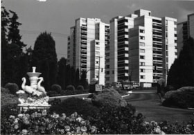
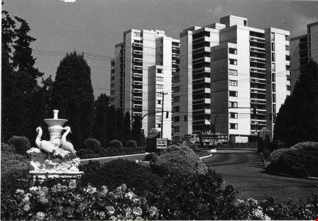
Ocean View Memorial Park
https://search.heritageburnaby.ca/link/archivedescription79075
- Repository
- City of Burnaby Archives
- Date
- September 8, 1976
- Collection/Fonds
- Burnaby Public Library Contemporary Visual Archive Project
- Description Level
- Item
- Physical Description
- 1 photograph : b&w ; 11 x 16 cm mounted on cardboard
- Scope and Content
- Photograph of landscaping and ornament just inside the main entrance of Ocean View Memorial Park at the corner of Imperial Street and Patterson Avenue.
- Repository
- City of Burnaby Archives
- Date
- September 8, 1976
- Collection/Fonds
- Burnaby Public Library Contemporary Visual Archive Project
- Physical Description
- 1 photograph : b&w ; 11 x 16 cm mounted on cardboard
- Description Level
- Item
- Record No.
- 556-136
- Access Restriction
- No restrictions
- Reproduction Restriction
- Reproduce for fair dealing purposes only
- Accession Number
- 2013-13
- Scope and Content
- Photograph of landscaping and ornament just inside the main entrance of Ocean View Memorial Park at the corner of Imperial Street and Patterson Avenue.
- Subjects
- Cemeteries
- Names
- Ocean View Burial Park
- Media Type
- Photograph
- Photographer
- Ross, Martha
- Notes
- Scope note taken directly from BPL photograph description.
- 1 b&w copy negative : 10 x 12.5 cm accompanying
- Geographic Access
- Imperial Street
- Street Address
- 4000 Imperial Street
- Historic Neighbourhood
- Central Park (Historic Neighbourhood)
- Planning Study Area
- Suncrest Area
Images
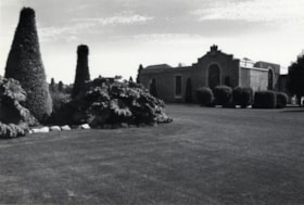
Ocean View Memorial Park
https://search.heritageburnaby.ca/link/archivedescription79077
- Repository
- City of Burnaby Archives
- Date
- September 8, 1976
- Collection/Fonds
- Burnaby Public Library Contemporary Visual Archive Project
- Description Level
- Item
- Physical Description
- 1 photograph : b&w ; 11 x 16 cm mounted on cardboard
- Scope and Content
- Photograph of the mausoleum in Ocean View Memorial Park.
- Repository
- City of Burnaby Archives
- Date
- September 8, 1976
- Collection/Fonds
- Burnaby Public Library Contemporary Visual Archive Project
- Physical Description
- 1 photograph : b&w ; 11 x 16 cm mounted on cardboard
- Description Level
- Item
- Record No.
- 556-137
- Access Restriction
- No restrictions
- Reproduction Restriction
- Reproduce for fair dealing purposes only
- Accession Number
- 2013-13
- Scope and Content
- Photograph of the mausoleum in Ocean View Memorial Park.
- Subjects
- Cemeteries
- Names
- Ocean View Burial Park
- Media Type
- Photograph
- Photographer
- Ross, Martha
- Notes
- Scope note taken directly from BPL photograph description.
- 1 b&w copy negative : 10 x 12.5 cm accompanying
- Geographic Access
- Imperial Street
- Street Address
- 4000 Imperial Street
- Historic Neighbourhood
- Central Park (Historic Neighbourhood)
- Planning Study Area
- Suncrest Area
Images
