Narrow Results By
Subject
- Advertising Medium - Signs and Signboards 1
- Buildings - Commercial - Restaurants 1
- Clothing - Uniforms 1
- Events - May Day 3
- Events - Openings 2
- Events - Parades 1
- Geographic Features - Mountains 1
- Geographic Features - Parks 3
- Musical Instruments - Bagpipes 1
- Officials - Mayors and Reeves 1
- Persons - Crowds 3
- Symbols - Flags 2
Creator
- Bartel, Mario 10
- British Columbia Underwriters' Association
- Cheung, Nakita 1
- George Allen Aerial Photos Limited 1
- King, Basil 2
- Lloyd, Frank Ernest 10
- Lloyd's Studio
- Neonette Sign Company
- Pasch, Rebecca 1
- Plan Department, British Columbia Insurance Underwriters' Association 1
- Province of British Columbia 2
- Ray, Steve 1

Arrow Neon Sign
https://search.heritageburnaby.ca/link/landmark861
- Repository
- Burnaby Heritage Planning
- Description
- Commercial building.
- Associated Dates
- 1961
- Other Names
- Lost in the 50's Drive-in
- Street View URL
- Google Maps Street View
- Repository
- Burnaby Heritage Planning
- Other Names
- Lost in the 50's Drive-in
- Geographic Access
- Edmonds Street
- Associated Dates
- 1961
- Description
- Commercial building.
- Heritage Value
- The Arrow Neon Sign was built in 1961 by the Neonette Sign Company of New Westminster when this property was opened as the Tomahawk Drive-in Restaurant. The restaurant was later known as Lindy's Burger and in 1990, the business was renamed Lost in the 50's Drive-in. It stands 20-foot tall and is composed of a large double-sided hollow steel panel serpentine arrow mounted on a pole supporting a lexan sign panel measuring approximately 8 feet wide by 4 feet tall. The sign was designed with three illuminated features: a round lamp at the top of the pole, a double-sided rectangular fluorescent sign panel box, and two double-sided rows of orange neon arrows that follow the large serpentine arrow. The Arrow Neon Sign remains as a rare surviving example of neon sign art in the city and is the only historic neon sign in South Burnaby. The sign has gained prominence over the years as it has been associated with this small iconic drive-in which has also been utilized as a set for film production. Additionally, the drive-in has played a prominent role in the Edmonds community as a popular setting for recent "Show and Shine" participants to park their classic cars.
- Locality
- Edmonds
- Historic Neighbourhood
- East Burnaby (Historic Neighbourhood)
- Planning Study Area
- Lakeview-Mayfield Area
- Builder
- Neonette Sign Company
- Community
- Burnaby
- Contributing Resource
- Structure
- Ownership
- Public (local)
- Street Address
- 7741 Edmonds Street
- Street View URL
- Google Maps Street View
Images


Henry & Elsa Ramsay Residence
https://search.heritageburnaby.ca/link/landmark592
- Repository
- Burnaby Heritage Planning
- Description
- Residential building.
- Associated Dates
- 1912
- Street View URL
- Google Maps Street View
- Repository
- Burnaby Heritage Planning
- Geographic Access
- Stanley Street
- Associated Dates
- 1912
- Description
- Residential building.
- Heritage Value
- This house was built for Henry Ramsay and his wife, Elsa Kirby (née Burnett), who were married at Holy Trinity Cathedral in New Westminster in 1910. Henry was a real estate agent, originally from Newcastle-on-Tyne, England. Beautifully designed in the Arts and Crafts style, it follows the ideals of the movement in the use of native materials. The wooden construction includes timber porch and roof brackets. The roofline is of a notably low pitch. English-born architect Robert Mackay Fripp (1858-1917) had a varied career working at various times in England, New Zealand and Los Angeles. Fripp found the opportunity in British Columbia to promote his passion for British Arts and Crafts aesthetics through a series of residential and institutional commissions. The Ramsay Residence was built at the height of the Arts and Crafts movement, and Fripp’s output during this period was prolific; his residential designs ranged from modest California bungalows to stately Tudor Revival homes in Shaughnessy, Point Grey and Kerrisdale. This elegant house was built by contractor C.G. Bowden.
- Locality
- Burnaby Lake
- Historic Neighbourhood
- Burnaby Lake (Historic Neighbourhood)
- Planning Study Area
- Lakeview-Mayfield Area
- Architect
- Robert Mackay Fripp
- Area
- 1211.15
- Contributing Resource
- Building
- Ownership
- Private
- Street Address
- 7864 Stanley Street
- Street View URL
- Google Maps Street View
Images


Burnaby May Day
https://search.heritageburnaby.ca/link/archivedescription34269
- Repository
- City of Burnaby Archives
- Date
- May 26, 1928
- Collection/Fonds
- Burnaby Historical Society fonds
- Description Level
- Item
- Physical Description
- 1 photograph : b&w ; 11.6 x 17.2 cm
- Scope and Content
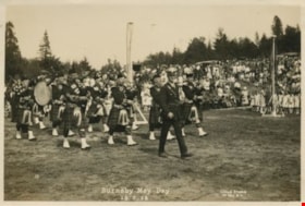
- Photograph of Burnaby May Day celebrations showing a man in uniform leading a bagpipe band on a field. Maypoles and a crowd can be seen in the background.
- Repository
- City of Burnaby Archives
- Date
- May 26, 1928
- Collection/Fonds
- Burnaby Historical Society fonds
- Subseries
- George Jeffery subseries
- Physical Description
- 1 photograph : b&w ; 11.6 x 17.2 cm
- Description Level
- Item
- Record No.
- 013-013
- Access Restriction
- No restrictions
- Reproduction Restriction
- No known restrictions
- Accession Number
- BHS2007-04
- Scope and Content
- Photograph of Burnaby May Day celebrations showing a man in uniform leading a bagpipe band on a field. Maypoles and a crowd can be seen in the background.
- Media Type
- Photograph
- Photographer
- Lloyd's Studio
- Notes
- Annotation at bottom of photograph reads, "33 / Burnaby May Day 26-5-28"
- Back of photograph stamped, "Lloyd's Studio / 3966 Kingsway / McKay, BC, Carl. 343R2"
- Geographic Access
- Robert Burnaby Park
- Wedgewood Street
- Street Address
- 8155 Wedgewood Street
- Historic Neighbourhood
- Burnaby Lake (Historic Neighbourhood)
- Planning Study Area
- Lakeview-Mayfield Area
Images

Burnaby May Day
https://search.heritageburnaby.ca/link/archivedescription35326
- Repository
- City of Burnaby Archives
- Date
- May 26, 1928
- Collection/Fonds
- Burnaby Historical Society fonds
- Description Level
- Item
- Physical Description
- 1 photograph : b&w ; 12.7 x 17.8 cm print
- Scope and Content
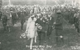
- Photograph of 1928 May Queen, Sylvia Murley (foreground, left) with Reeve Thomas Sanderson (foreground, centre) and Scoutmaster Tom Corbett (foreground, right) at Robert Burnaby Park. Sylvia Murley became Sylvia Auvache when she married Lewis Auvache, who would be Burnaby's Fire Chief between 1964…
- Repository
- City of Burnaby Archives
- Date
- May 26, 1928
- Collection/Fonds
- Burnaby Historical Society fonds
- Subseries
- Pioneer Tales subseries
- Physical Description
- 1 photograph : b&w ; 12.7 x 17.8 cm print
- Description Level
- Item
- Record No.
- 204-183
- Access Restriction
- No restrictions
- Reproduction Restriction
- No known restrictions
- Accession Number
- BHS1988-03
- Scope and Content
- Photograph of 1928 May Queen, Sylvia Murley (foreground, left) with Reeve Thomas Sanderson (foreground, centre) and Scoutmaster Tom Corbett (foreground, right) at Robert Burnaby Park. Sylvia Murley became Sylvia Auvache when she married Lewis Auvache, who would be Burnaby's Fire Chief between 1964 and 1972.
- Media Type
- Photograph
- Photographer
- Lloyd's Studio
- Notes
- Title based on caption on photograph
- Geographic Access
- Robert Burnaby Park
- Wedgewood Street
- Street Address
- 8155 Wedgewood Street
- Historic Neighbourhood
- Burnaby Lake (Historic Neighbourhood)
- Planning Study Area
- Lakeview-Mayfield Area
Images


Burnaby Park
https://search.heritageburnaby.ca/link/archivedescription34577
- Repository
- City of Burnaby Archives
- Date
- 1927
- Collection/Fonds
- Burnaby Historical Society fonds
- Description Level
- Item
- Physical Description
- 1 photograph : b&w ; 34.5 x 23.3 cm mounted on 49.5 x 35.1 cm cardboard
- Scope and Content
- Photograph taken from Burnaby Park, including trees and mountains in the distance.
- Repository
- City of Burnaby Archives
- Date
- 1927
- Collection/Fonds
- Burnaby Historical Society fonds
- Subseries
- Photographs subseries
- Physical Description
- 1 photograph : b&w ; 34.5 x 23.3 cm mounted on 49.5 x 35.1 cm cardboard
- Description Level
- Item
- Record No.
- 055-002
- Access Restriction
- No restrictions
- Reproduction Restriction
- No known restrictions
- Accession Number
- BHS2007-04
- Scope and Content
- Photograph taken from Burnaby Park, including trees and mountains in the distance.
- Media Type
- Photograph
- Photographer
- Lloyd's Studio
- Notes
- Title based on contents of photograph
- Annotation on bottom front of cardboard reads, "Burnaby Park / Officially Opened August 6th, 1927"
- Geographic Access
- Robert Burnaby Park
- Wedgewood Street
- Street Address
- 8155 Wedgewood Street
- Historic Neighbourhood
- Burnaby Lake (Historic Neighbourhood)
- Planning Study Area
- Lakeview-Mayfield Area
Images

Crowning the May Queen
https://search.heritageburnaby.ca/link/archivedescription38673
- Repository
- City of Burnaby Archives
- Date
- 1928
- Collection/Fonds
- Burnaby Historical Society fonds
- Description Level
- Item
- Physical Description
- 1 photograph : b&w ; 20 x 24.5 cm
- Scope and Content
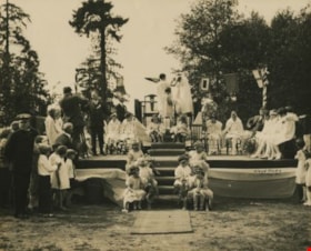
- Photograph of the crowning ceremony for Burnaby's 1928-1929 May Queen, Sylvia Murley on the raised dais receiving her crown, flanked by numerous flower girls and attendants.
- Repository
- City of Burnaby Archives
- Date
- 1928
- Collection/Fonds
- Burnaby Historical Society fonds
- Subseries
- North Burnaby Board of Trade subseries
- Physical Description
- 1 photograph : b&w ; 20 x 24.5 cm
- Description Level
- Item
- Record No.
- 476-016
- Access Restriction
- No restrictions
- Reproduction Restriction
- No known restrictions
- Accession Number
- BHS2005-8
- Scope and Content
- Photograph of the crowning ceremony for Burnaby's 1928-1929 May Queen, Sylvia Murley on the raised dais receiving her crown, flanked by numerous flower girls and attendants.
- Subjects
- Events - May Day
- Media Type
- Photograph
- Photographer
- Lloyd's Studio
- Notes
- Title based on contents of photograph
- Geographic Access
- Robert Burnaby Park
- Wedgewood Street
- Street Address
- 8155 Wedgewood Street
- Historic Neighbourhood
- East Burnaby (Historic Neighbourhood)
- Planning Study Area
- Lakeview-Mayfield Area
Images


Municipality of Burnaby - Volume XV, Volume XVI, Volume XVII, Volume XVIII
https://search.heritageburnaby.ca/link/museumdescription8685
- Repository
- Burnaby Village Museum
- Date
- May 1927
- Collection/Fonds
- Burnaby Village Museum Map collection
- Description Level
- File
- Physical Description
- 4 plans on 4 sheets : col. lithographic prints ; 63.5 x 53.5 cm folded to 53 x 31.5 cm
- Scope and Content
- File consists of four pages of plans removed from a bound book containing a series of fire insurance plans of the Municipality of Burnaby. Plan "1531" is part of "GREATER VANCOUVER B.C. / VOLUME XV / Municipality of Burnaby / May 1927" and covers District Lots: 116 and 117. Key Plan "C" is part of …
- Repository
- Burnaby Village Museum
- Collection/Fonds
- Burnaby Village Museum Map collection
- Description Level
- File
- Physical Description
- 4 plans on 4 sheets : col. lithographic prints ; 63.5 x 53.5 cm folded to 53 x 31.5 cm
- Material Details
- Scale [1:600] and [1:1200]
- Scope and Content
- File consists of four pages of plans removed from a bound book containing a series of fire insurance plans of the Municipality of Burnaby. Plan "1531" is part of "GREATER VANCOUVER B.C. / VOLUME XV / Municipality of Burnaby / May 1927" and covers District Lots: 116 and 117. Key Plan "C" is part of "GREATER VANCOUVER B.C. / VOLUME XVI / Municipality of Burnaby / May 1927" and covers plans 1623 to 1651 and District Lots: 1 and 2; 4; 6; 8; 10 to 14; 25; 27; 40; 56 to 58; 88 and 89. Plan "1738" is part of "GREATER VANCOUVER B.C. / VOLUME XVII / Municipality of Burnaby / May 1927" and covers District Lots: 34 and 35. Key plan "G" is part of "GREATER VANCOUVER B.C. / VOLUME XVIII / Municipality of Burnaby / May 1927" and covers plans: 1801 to 1813; 1823; 1824; 1833 to 1838; 1841 to 1853 and District Lots: 32; 93; 94; 97 to 99; 149; 150; 152; 155 to 159; 161 to 164.
- Responsibility
- British Columbia Underwriters' Association
- Accession Code
- HV972.111.7
- Access Restriction
- No restrictions
- Reproduction Restriction
- May be restricted by third party rights
- Date
- May 1927
- Media Type
- Cartographic Material
- Historic Neighbourhood
- Central Park (Historic Neighbourhood)
- Fraser Arm (Historic Neighbourhood)
- Alta Vista (Historic Neighbourhood)
- Broadview (Historic Neighbourhood)
- Vancouver Heights (Historic Neighbourhood)
- Burquitlam (Historic Neighbourhood)
- East Burnaby (Historic Neighbourhood)
- Edmonds (Historic Neighbourhood)
- Lozells (Historic Neighbourhood)
- Planning Study Area
- Clinton-Glenwood Area
- Marlborough Area
- Maywood Area
- Windsor Area
- Big Bend Area
- Garden Village Area
- Willingdon Heights Area
- West Central Valley Area
- Cariboo-Armstrong Area
- Lyndhurst Area
- Cameron Area
- Lake City Area
- Edmonds Area
- Second Street Area
- Sperling-Broadway Area
- Lakeview-Mayfield Area
- Scan Resolution
- 400
- Scan Date
- 2021-11-18
- Notes
- Title based on content of plans
- See also BV987.1.70d for revised versions of plans
- Scale is measured 1 inch = 500 feet
Zoomable Images

Municipality of Burnaby - Volume XV, Volume XVI, Volume XVII, Volume XVIII, May 1927
Zoom into Image
Opening of Burnaby Park
https://search.heritageburnaby.ca/link/archivedescription34257
- Repository
- City of Burnaby Archives
- Date
- August 6, 1927
- Collection/Fonds
- Burnaby Historical Society fonds
- Description Level
- Item
- Physical Description
- 1 photograph : b&w ; 11.7 x 16.7 cm
- Scope and Content
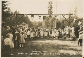
- Photograph of the opening of Burnaby Park at the foot of 2nd Street. The photograph was likely taken just after the ribbon cutting.
- Repository
- City of Burnaby Archives
- Date
- August 6, 1927
- Collection/Fonds
- Burnaby Historical Society fonds
- Subseries
- George Jeffery subseries
- Physical Description
- 1 photograph : b&w ; 11.7 x 16.7 cm
- Description Level
- Item
- Record No.
- 013-001
- Access Restriction
- No restrictions
- Reproduction Restriction
- No known restrictions
- Accession Number
- BHS2007-04
- Scope and Content
- Photograph of the opening of Burnaby Park at the foot of 2nd Street. The photograph was likely taken just after the ribbon cutting.
- Media Type
- Photograph
- Photographer
- Lloyd's Studio
- Notes
- Title based on caption of photograph
- Annotation at bottom of photograph reads, "Burnaby Park / Official Opening, August 6th 1927"
- Geographic Access
- Wedgewood Street
- Robert Burnaby Park
- Street Address
- 8155 Wedgewood Street
- Historic Neighbourhood
- Burnaby Lake (Historic Neighbourhood)
- Planning Study Area
- Lakeview-Mayfield Area
Images

Opening of Burnaby Park
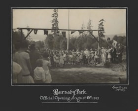
https://search.heritageburnaby.ca/link/archivedescription34576
- Repository
- City of Burnaby Archives
- Date
- August 6, 1927
- Collection/Fonds
- Burnaby Historical Society fonds
- Description Level
- Item
- Physical Description
- 1 photograph : b&w ; 15.8 x 24.2 cm mounted on 29.1 x 38.7 cm cardboard
- Scope and Content
- Photograph of the official opening of Burnaby Park at the foot of 2nd Street. A crowd is gathered under an arch decorated with flags, and a ribbon is stretched across the arch.
- Repository
- City of Burnaby Archives
- Date
- August 6, 1927
- Collection/Fonds
- Burnaby Historical Society fonds
- Subseries
- Photographs subseries
- Physical Description
- 1 photograph : b&w ; 15.8 x 24.2 cm mounted on 29.1 x 38.7 cm cardboard
- Description Level
- Item
- Record No.
- 055-001
- Access Restriction
- No restrictions
- Reproduction Restriction
- No known restrictions
- Accession Number
- BHS2007-04
- Scope and Content
- Photograph of the official opening of Burnaby Park at the foot of 2nd Street. A crowd is gathered under an arch decorated with flags, and a ribbon is stretched across the arch.
- Media Type
- Photograph
- Photographer
- Lloyd's Studio
- Notes
- Title based on contents of photograph
- Annotation on bottom front of cardboard reads, "Burnaby Park / Official Opening, August 6th, 1927"
- Geographic Access
- Robert Burnaby Park
- Wedgewood Street
- Street Address
- 8155 Wedgewood Street
- Historic Neighbourhood
- Burnaby Lake (Historic Neighbourhood)
- Planning Study Area
- Lakeview-Mayfield Area
Images
