Narrow Results By

First Central Park B.P. Boy Scouts, 1910
https://search.heritageburnaby.ca/link/museumdescription1055
- Repository
- Burnaby Village Museum
- Date
- 1910
- Collection/Fonds
- Burnaby Village Museum Photograph collection
- Description Level
- Item
- Physical Description
- 1 photograph : b&w ; 12.1 x 17.3 cm mounted on cardboard 22.0 x 27.0 cm
- Scope and Content
- Photograph of the First Central Park troop of Boy Scouts. All but two of them are in uniform, standing at attention. There are 22 boys and 7 men. A man in the centre is holding a flagpole with a Union Jack attached. The Boy Scouts are standing on a cleared field behind which is a building and fores…
- Repository
- Burnaby Village Museum
- Collection/Fonds
- Burnaby Village Museum Photograph collection
- Description Level
- Item
- Physical Description
- 1 photograph : b&w ; 12.1 x 17.3 cm mounted on cardboard 22.0 x 27.0 cm
- Scope and Content
- Photograph of the First Central Park troop of Boy Scouts. All but two of them are in uniform, standing at attention. There are 22 boys and 7 men. A man in the centre is holding a flagpole with a Union Jack attached. The Boy Scouts are standing on a cleared field behind which is a building and forest growth. The location may be Central Park. A caption printed on the bottom front of the frame reads, "First Central Park / B.P. Boy Scou [sic] / 1910." Printed on the lower right front of the frame, "W. Brown, Photo. / New Westminster, B.C."
- Names
- Boy Scouts of Canada
- Geographic Access
- Central Park
- Imperial Street
- Street Address
- 3883 Imperial Street
- Accession Code
- HV973.152.2
- Access Restriction
- No restrictions
- Reproduction Restriction
- No known restrictions
- Date
- 1910
- Media Type
- Photograph
- Historic Neighbourhood
- Central Park (Historic Neighbourhood)
- Planning Study Area
- Maywood Area
- Related Material
- See HV973.152.1 for another photograph of the first central park BP boy scouts.
- Scan Resolution
- 600
- Scan Date
- 2023-06-06
- Photographer
- Brown, William Thomas
- Notes
- Title based on caption of photograph
Images


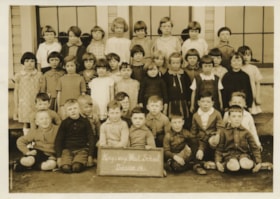
Kingsway West Division 14
https://search.heritageburnaby.ca/link/museumdescription1323
- Repository
- Burnaby Village Museum
- Date
- May 1927
- Collection/Fonds
- Burnaby Village Museum Photograph collection
- Description Level
- Item
- Physical Description
- 1 photograph : sepia ; 11.5 x 16 cm
- Scope and Content
- Photograph of Division 14 at Kingsway West School standing and sitting in five rows in front of the school building windows. Two boys sitting in the front row are holding up a chalk board which reads, "Kingsway West School/ Division 14." Standing in the top row (l to r) are; Audrey Browne, Joan Gol…
- Repository
- Burnaby Village Museum
- Collection/Fonds
- Burnaby Village Museum Photograph collection
- Description Level
- Item
- Physical Description
- 1 photograph : sepia ; 11.5 x 16 cm
- Scope and Content
- Photograph of Division 14 at Kingsway West School standing and sitting in five rows in front of the school building windows. Two boys sitting in the front row are holding up a chalk board which reads, "Kingsway West School/ Division 14." Standing in the top row (l to r) are; Audrey Browne, Joan Gold, Ida Wright, May Ford, Mabel Law, Dorothy Barber, Gladys Would and Isabel McFadyen. In the second row are; Betty Dermott, Maria Soda, Dorothy Guthrie, Pearl Rouse, Norma Moller, Marrion Hickenbotham, Priscilla Deane, Barbara Sleeth and Elsie Brown. In the third row are; Patricia Hodgson, Verna Crane, Gladys Nuttall, Muriel Iraine, Dorothy McKenzie, Doris Faulkner and Mildred Rutledge. Sitting in the fourth row are; James Murie, Bobby Shewan, Donald McKinnon, Howard Griffiths, Henry Nevin and Bobby Ferguson. In the front row are; Harvey Knorr, Alfred Younger, George Chamberlain (holding chalkboard), Ben Jacobson (holding chalkboard), Alex Walker and Garnet Eckard.
- Names
- Kingsway West School
- Browne, Audrey
- Gold, Joan
- Wright, Ida
- Ford, May
- Law, Mabel
- Barber, Dorothy
- Would, Gladys
- McFadyen, Isabel
- Dermott, Betty
- Soda, Maria
- Guthrie, Dorothy
- Rouse, Pearl
- Mollar, Norma
- Hickenbotham, Marion
- Deane, Priscilla
- Sleeth, Barbara
- Brown, Elsie
- Hodgson, Patricia
- Crane, Verna
- Nuttall, Gladys
- Iraine, Muriel
- McKenzie, Dorothy
- Faulkner, Doris
- Rutledge, Mildred
- Murie, James
- Shewan, Bobby
- McKinnon, Donald
- Griffiths, Howard
- Nevin, Henry
- Ferguson, Robert
- Knorr, Harvey
- Younger, Alfred
- Chamberlain, George
- Jacobson, Ben
- Walker, Alex
- Eckard, Garnet
- Geographic Access
- Kingsway
- Street Address
- 4800 Kingsway
- Accession Code
- BV999.2.11
- Access Restriction
- No restrictions
- Reproduction Restriction
- May be restricted by third party rights
- Date
- May 1927
- Media Type
- Photograph
- Historic Neighbourhood
- Central Park (Historic Neighbourhood)
- Planning Study Area
- Maywood Area
- Scan Resolution
- 600
- Scan Date
- 02-Jun-09
- Scale
- 100
- Photographer
- Bryce, Henry G.
- Notes
- Stamps on verso of photograph read: "25cents each. Please/ order number paid for" and "H. G. BRYCE, EDMONDS, B.C."
- Note in black ink on verso of photograph reads: "Div 14. Kingsway W. May, 1927/ Top row - left to right Audrey Browne, Joan Gold, Ida Wright, May Ford, Mabel Law, Dorothy Barber, Gladys Would, Isabel McFadyen / 2nd row lt. to rt. Betty Dermott, Maria Soda, Patricia Hodgson, Dorothy Guthrie, Verna Crane, Pearl Rause, Gladys Nuttal, Norma Moller, Muriel Iraine, Marrion Hickenbotham, Dorothy McKenzie/ 3rd row Doris Faulkner, Barbara Sleeth, Priscilla Deane, Mildred Rutledge, Elsie Brawn, Boys. James Murie, Bobby Shewan, Donald McKinnon, Howard Griffiths, Henry Nevin, Bobby Ferguson/ 2nd row Harvey Knorr, Alfred Younger, George Chamberlain, Ben Jacobson, Alex Walker, Garnet Eckard"
Images


Municipality of Burnaby - Volume XV and Volume XVIII
https://search.heritageburnaby.ca/link/museumdescription8680
- Repository
- Burnaby Village Museum
- Date
- May 1927
- Collection/Fonds
- Burnaby Village Museum Map collection
- Description Level
- File
- Physical Description
- 4 plans on 4 sheets : col. lithographic prints ; 63.5 x 53.5 cm folded to 53 x 31.5 cm
- Scope and Content
- File consists of four pages of plans removed from a bound book containing a series of fire insurance plans of the Municipality of Burnaby. The first two pages are numbered "A" and "B" and are key plans from "GREATER VANCOUVER B.C. / VOLUME XV / Surveyed _ May 1927 / MUNICIPALITY OF / BURNABY", "PLA…
- Repository
- Burnaby Village Museum
- Collection/Fonds
- Burnaby Village Museum Map collection
- Description Level
- File
- Physical Description
- 4 plans on 4 sheets : col. lithographic prints ; 63.5 x 53.5 cm folded to 53 x 31.5 cm
- Material Details
- Scales [1:1200] and [1:6000]
- Scope and Content
- File consists of four pages of plans removed from a bound book containing a series of fire insurance plans of the Municipality of Burnaby. The first two pages are numbered "A" and "B" and are key plans from "GREATER VANCOUVER B.C. / VOLUME XV / Surveyed _ May 1927 / MUNICIPALITY OF / BURNABY", "PLAN DEPT. FIRE BRANCH _ B.C. INSURANCE UNDERWRITERS ASSN.". Key Plan "B" covers plans: 1505; 1506; 1512 to 1516; 1540 to 1544; 1550 to 1557 and District Lots: 129 to 132; 135 to 138; 205 to 208 and 215 to 218. Key Plan "A" covers plans: 1501 to 1504; 1507 to 1511; 1517 to 1525; 1531 to 1539; 1545 to 1550 and District Lots: 116 to 127 and 186 to 189. Plan "1806" is part of "GREATER VANCOUVER B.C. / VOLUME XVIII / Municipality of Burnaby / May, 1927" and covers District Lot 153. Plan "1807" is from "GREATER VANCOUVER B.C. / VOLUME XVIII / Municipality of Burnaby / May, 1927" and covers District Lots: 99,149 and 152.
- Responsibility
- British Columbia Underwriters' Association
- Accession Code
- HV972.111.2
- Access Restriction
- No restrictions
- Reproduction Restriction
- May be restricted by third party rights
- Date
- May 1927
- Media Type
- Cartographic Material
- Historic Neighbourhood
- Vancouver Heights (Historic Neighbourhood)
- Lochdale (Historic Neighbourhood)
- Capitol Hill (Historic Neighbourhood)
- Central Park (Historic Neighbourhood)
- Alta Vista (Historic Neighbourhood)
- Planning Study Area
- Burnaby Heights Area
- Sperling-Broadway Area
- Lochdale Area
- Parkcrest-Aubrey Area
- Westridge Area
- Willingdon Heights Area
- Capitol Hill Area
- Maywood Area
- Marlborough Area
- Scan Resolution
- 400
- Scan Date
- 2021-11-18
- Notes
- Title based on content of plans
- Scales are measured 1 inch = 100 feet and 1 inch = 500 feet
- See also BV987.1.70d for revised versions of plans
Zoomable Images


Municipality of Burnaby - Volume XV and Volume XVIII
https://search.heritageburnaby.ca/link/museumdescription8681
- Repository
- Burnaby Village Museum
- Date
- May 1927
- Collection/Fonds
- Burnaby Village Museum Map collection
- Description Level
- File
- Physical Description
- 4 plans on 4 sheets : col. lithographic prints, ms. annotations in blue ink ; 63.5 x 53.5 cm folded to 53 x 31.5 cm
- Scope and Content
- File consists of four pages of plans removed from a bound book containing a series of fire insurance plans of the Municipality of Burnaby. Plan "1507" and plan "1517" are from "GREATER VANCOUVER B.C. / VOLUME XV / Municipality of Burnaby / May, 1927". Plan "1507" covers District Lot 186 and plan "1…
- Repository
- Burnaby Village Museum
- Collection/Fonds
- Burnaby Village Museum Map collection
- Description Level
- File
- Physical Description
- 4 plans on 4 sheets : col. lithographic prints, ms. annotations in blue ink ; 63.5 x 53.5 cm folded to 53 x 31.5 cm
- Material Details
- Scale [1:600] and [1:1200]
- Scope and Content
- File consists of four pages of plans removed from a bound book containing a series of fire insurance plans of the Municipality of Burnaby. Plan "1507" and plan "1517" are from "GREATER VANCOUVER B.C. / VOLUME XV / Municipality of Burnaby / May, 1927". Plan "1507" covers District Lot 186 and plan "1517" covers District Lot 116. Plan "1804" and plan "1805" are from "GREATER VANCOUVER B.C. / VOLUME XVIII / Municipality of Burnaby / May, 1927". Plans "1804" and "1805" cover District Lot 153.
- Responsibility
- British Columbia Underwriters' Association
- Accession Code
- HV972.111.3
- Access Restriction
- No restrictions
- Reproduction Restriction
- May be restricted by third party rights
- Date
- May 1927
- Media Type
- Cartographic Material
- Historic Neighbourhood
- Central Park (Historic Neighbourhood)
- Vancouver Heights (Historic Neighbourhood)
- Planning Study Area
- Maywood Area
- Willingdon Heights Area
- Scan Resolution
- 400
- Scan Date
- 2021-11-18
- Notes
- Title based on content of plans
- See also BV987.1.70d for revised versions of plans
- Scale is measured 1 inch = 100 feet
Images


Municipality of Burnaby - Volume XV, Volume XVI, Volume XVII, Volume XVIII
https://search.heritageburnaby.ca/link/museumdescription8685
- Repository
- Burnaby Village Museum
- Date
- May 1927
- Collection/Fonds
- Burnaby Village Museum Map collection
- Description Level
- File
- Physical Description
- 4 plans on 4 sheets : col. lithographic prints ; 63.5 x 53.5 cm folded to 53 x 31.5 cm
- Scope and Content
- File consists of four pages of plans removed from a bound book containing a series of fire insurance plans of the Municipality of Burnaby. Plan "1531" is part of "GREATER VANCOUVER B.C. / VOLUME XV / Municipality of Burnaby / May 1927" and covers District Lots: 116 and 117. Key Plan "C" is part of …
- Repository
- Burnaby Village Museum
- Collection/Fonds
- Burnaby Village Museum Map collection
- Description Level
- File
- Physical Description
- 4 plans on 4 sheets : col. lithographic prints ; 63.5 x 53.5 cm folded to 53 x 31.5 cm
- Material Details
- Scale [1:600] and [1:1200]
- Scope and Content
- File consists of four pages of plans removed from a bound book containing a series of fire insurance plans of the Municipality of Burnaby. Plan "1531" is part of "GREATER VANCOUVER B.C. / VOLUME XV / Municipality of Burnaby / May 1927" and covers District Lots: 116 and 117. Key Plan "C" is part of "GREATER VANCOUVER B.C. / VOLUME XVI / Municipality of Burnaby / May 1927" and covers plans 1623 to 1651 and District Lots: 1 and 2; 4; 6; 8; 10 to 14; 25; 27; 40; 56 to 58; 88 and 89. Plan "1738" is part of "GREATER VANCOUVER B.C. / VOLUME XVII / Municipality of Burnaby / May 1927" and covers District Lots: 34 and 35. Key plan "G" is part of "GREATER VANCOUVER B.C. / VOLUME XVIII / Municipality of Burnaby / May 1927" and covers plans: 1801 to 1813; 1823; 1824; 1833 to 1838; 1841 to 1853 and District Lots: 32; 93; 94; 97 to 99; 149; 150; 152; 155 to 159; 161 to 164.
- Responsibility
- British Columbia Underwriters' Association
- Accession Code
- HV972.111.7
- Access Restriction
- No restrictions
- Reproduction Restriction
- May be restricted by third party rights
- Date
- May 1927
- Media Type
- Cartographic Material
- Historic Neighbourhood
- Central Park (Historic Neighbourhood)
- Fraser Arm (Historic Neighbourhood)
- Alta Vista (Historic Neighbourhood)
- Broadview (Historic Neighbourhood)
- Vancouver Heights (Historic Neighbourhood)
- Burquitlam (Historic Neighbourhood)
- East Burnaby (Historic Neighbourhood)
- Edmonds (Historic Neighbourhood)
- Lozells (Historic Neighbourhood)
- Planning Study Area
- Clinton-Glenwood Area
- Marlborough Area
- Maywood Area
- Windsor Area
- Big Bend Area
- Garden Village Area
- Willingdon Heights Area
- West Central Valley Area
- Cariboo-Armstrong Area
- Lyndhurst Area
- Cameron Area
- Lake City Area
- Edmonds Area
- Second Street Area
- Sperling-Broadway Area
- Lakeview-Mayfield Area
- Scan Resolution
- 400
- Scan Date
- 2021-11-18
- Notes
- Title based on content of plans
- See also BV987.1.70d for revised versions of plans
- Scale is measured 1 inch = 500 feet
Zoomable Images

Municipality of Burnaby - Volume XV, Volume XVI, Volume XVII, Volume XVIII, May 1927
Zoom into Image
![West Burnaby Public School, [between 1900 and 1915] thumbnail](/media/hpo/_Data/_BVM_Images/1990/199900020047.jpg?width=280)
West Burnaby Public School
https://search.heritageburnaby.ca/link/museumdescription1357
- Repository
- Burnaby Village Museum
- Date
- [between 1900 and 1915]
- Collection/Fonds
- Burnaby Village Museum Photograph collection
- Description Level
- Item
- Physical Description
- 1 photograph : b&w ; 9 x 14 cm
- Scope and Content
- Photograph of a class at West Burnaby School (later renamed Kingsway West School). There are thirty boys and nineteen girls sitting and standing in four rows in front of the school building.
- Repository
- Burnaby Village Museum
- Collection/Fonds
- Burnaby Village Museum Photograph collection
- Description Level
- Item
- Physical Description
- 1 photograph : b&w ; 9 x 14 cm
- Scope and Content
- Photograph of a class at West Burnaby School (later renamed Kingsway West School). There are thirty boys and nineteen girls sitting and standing in four rows in front of the school building.
- Names
- Kingsway West School
- Geographic Access
- Kingsway
- Street Address
- 4800 Kingsway
- Accession Code
- BV999.2.47
- Access Restriction
- No restrictions
- Reproduction Restriction
- May be restricted by third party rights
- Date
- [between 1900 and 1915]
- Media Type
- Photograph
- Historic Neighbourhood
- Central Park (Historic Neighbourhood)
- Planning Study Area
- Maywood Area
- Scan Resolution
- 600
- Scan Date
- 08-Jun-09
- Scale
- 100
- Photographer
- Brown, William Thomas
- Notes
- Stamp on recto of photograph reads: " WEST BURNABY PUBLIC SCHOOL / W. BROWN. Photo."
Images
![West Burnaby Public School, [between 1900 and 1915] thumbnail](/media/hpo/_Data/_BVM_Images/1990/199900020047.jpg)
![West Burnaby School class, [1908] thumbnail](/media/hpo/_Data/_BVM_Images/1990/199900020033.jpg?width=280)
West Burnaby School class
https://search.heritageburnaby.ca/link/museumdescription1345
- Repository
- Burnaby Village Museum
- Date
- [1908]
- Collection/Fonds
- Burnaby Village Museum Photograph collection
- Description Level
- Item
- Physical Description
- 1 photograph : sepia postcard ; 9 x 14 cm
- Scope and Content
- Photographic postcard of more than forty students at West Burnaby (later renamed Kingsway West) School sitting and standing in six rows in front of a wooden fence. Their teacher Miss Annie Forrest, stands in the back, third from the left.
- Repository
- Burnaby Village Museum
- Collection/Fonds
- Burnaby Village Museum Photograph collection
- Description Level
- Item
- Physical Description
- 1 photograph : sepia postcard ; 9 x 14 cm
- Scope and Content
- Photographic postcard of more than forty students at West Burnaby (later renamed Kingsway West) School sitting and standing in six rows in front of a wooden fence. Their teacher Miss Annie Forrest, stands in the back, third from the left.
- Subjects
- Occupations - Teachers
- Geographic Access
- Kingsway
- Street Address
- 4800 Kingsway
- Accession Code
- BV999.2.33
- Access Restriction
- No restrictions
- Reproduction Restriction
- May be restricted by third party rights
- Date
- [1908]
- Media Type
- Photograph
- Historic Neighbourhood
- Central Park (Historic Neighbourhood)
- Planning Study Area
- Maywood Area
- Related Material
- For another photograph of the students in the group with Miss Forrest, see BV999.2.32
- Scan Resolution
- 600
- Scan Date
- 08-Jun-09
- Scale
- 100
- Photographer
- Brown, William Thomas
- Notes
- Title based on contents of photograph
- Stamp on recto of photograph reads: "WM. BROWN NEW WESTMINSTER. B. C."
Images
![West Burnaby School class, [1908] thumbnail](/media/hpo/_Data/_BVM_Images/1990/199900020033.jpg)
![West Burnaby School students, [1909] thumbnail](/media/hpo/_Data/_BVM_Images/1990/199900020032.jpg?width=280)
West Burnaby School students
https://search.heritageburnaby.ca/link/museumdescription1344
- Repository
- Burnaby Village Museum
- Date
- [1909]
- Collection/Fonds
- Burnaby Village Museum Photograph collection
- Description Level
- Item
- Physical Description
- 1 photograph : sepia postcard ; 11.5 x 16.5 cm
- Scope and Content
- Photographic postcard of more than fifty students at West Burnaby (later renamed Kingsway West) School sitting and standing in six rows in front of a wooden fence. A man in a suit stands in front of a high wood fence at the back in the centre and Miss Annie Forrest stands to the left.
- Repository
- Burnaby Village Museum
- Collection/Fonds
- Burnaby Village Museum Photograph collection
- Description Level
- Item
- Physical Description
- 1 photograph : sepia postcard ; 11.5 x 16.5 cm
- Material Details
- Stamp on recto of photograph reads: "WM. BROWN NEW WESTMINSTER. B. C."
- Scope and Content
- Photographic postcard of more than fifty students at West Burnaby (later renamed Kingsway West) School sitting and standing in six rows in front of a wooden fence. A man in a suit stands in front of a high wood fence at the back in the centre and Miss Annie Forrest stands to the left.
- Subjects
- Occupations - Teachers
- Geographic Access
- Kingsway
- Street Address
- 4800 Kingsway
- Accession Code
- BV999.2.32
- Access Restriction
- No restrictions
- Reproduction Restriction
- May be restricted by third party rights
- Date
- [1909]
- Media Type
- Photograph
- Historic Neighbourhood
- Central Park (Historic Neighbourhood)
- Planning Study Area
- Maywood Area
- Related Material
- For another photograph of some of the students in the group with Miss Forrest, see BV999.2.33
- Scan Resolution
- 600
- Scan Date
- 08-Jun-09
- Scale
- 100
- Photographer
- Brown, William Thomas
- Notes
- Title based on contents of photograph
- A second copy of this postcard is held in the collection as BV994.21.1.
Images
![West Burnaby School students, [1909] thumbnail](/media/hpo/_Data/_BVM_Images/1990/199900020032.jpg)