Narrow Results By
Creator
- Bartel, Mario 2
- Battistoni, Peter 2
- Born, A. J.
- Burnaby Village Museum 3
- Damer, Eric 1
- Ford, Rolly 1
- Government of Canada - Department of the Interior
- Graphic Industries Limited 3
- Hodge, Craig 5
- King, Basil 2
- McLean, George H.F. 2
- Printed on back of postcard: "Pub, by Natural Color Productions, Ltd., Vancouver, B.C.," "Made in Canada, Grant-Mann," and "GM: Lithography, Photography, Design" 1
Map of the Dominion of Canada
https://search.heritageburnaby.ca/link/museumdescription18944
- Repository
- Burnaby Village Museum
- Date
- 1911
- Collection/Fonds
- Burnaby Village Museum Map collection
- Description Level
- Item
- Physical Description
- 1 map : col. lithographic print on white paper ; 49.5 x 88.5 cm on sheet 63.5 x 90.5 cm
- Scope and Content
- Item consists of a "MAP OF THE DOMINION OF CANADA" produced by the Department of the Interior in 1911 . Text in lower border below map reads "THIS MAP IS PRESENTED WITH THE COMPLIMENTS OF THE ROYAL BANK OF CANADA" "WITH ITS FORTY-SECOND ANNUAL REPORT, 31st DECEMBER, 1911" at bottom centre, with lis…
- Repository
- Burnaby Village Museum
- Collection/Fonds
- Burnaby Village Museum Map collection
- Description Level
- Item
- Physical Description
- 1 map : col. lithographic print on white paper ; 49.5 x 88.5 cm on sheet 63.5 x 90.5 cm
- Material Details
- Scale: 100 miles = 1 inch
- Scope and Content
- Item consists of a "MAP OF THE DOMINION OF CANADA" produced by the Department of the Interior in 1911 . Text in lower border below map reads "THIS MAP IS PRESENTED WITH THE COMPLIMENTS OF THE ROYAL BANK OF CANADA" "WITH ITS FORTY-SECOND ANNUAL REPORT, 31st DECEMBER, 1911" at bottom centre, with list of branches in Canada and in other countries; at left is list of "PRINCIPAL FOREIGN CORRESPONDENTS"; at right is general information, "INCORPORATED 1869", "HEAD OFFICE MONTREAL", with "CAPITAL PAID UP", "RESERVE FUNDS", "AGGREGATE ASSETS" all listed, and "BOARD OF DIRECTORS" listed. Map shows proposed additions to Quebec, Ontario and Manitoba. Provincial and territorial borders, shipping routes, railway lines are identified. Two charts at upper right of distances, red print, one for distances in Canada from Montreal, the other for Montreal, Halifax and Churchill to foreign ports.
- Publisher
- Royal Bank of Canada
- Accession Code
- BV988.56.4
- Access Restriction
- No restrictions
- Reproduction Restriction
- No known restrictions
- Date
- 1911
- Media Type
- Cartographic Material
- Notes
- Title based on contents of map

Construction Project
https://search.heritageburnaby.ca/link/archivedescription79377
- Repository
- City of Burnaby Archives
- Date
- October 1, 1976
- Collection/Fonds
- Burnaby Public Library Contemporary Visual Archive Project
- Description Level
- Item
- Physical Description
- 1 photograph : b&w ; 11 x 16 cm mounted on cardboard
- Scope and Content
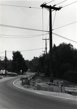
- Photograph shows a construction project by BC Hydro at Broadway and Cliff Avenue to bury transmission cables. The work was contracted to G.M. Gest Construction of Montreal.
- Repository
- City of Burnaby Archives
- Date
- October 1, 1976
- Collection/Fonds
- Burnaby Public Library Contemporary Visual Archive Project
- Physical Description
- 1 photograph : b&w ; 11 x 16 cm mounted on cardboard
- Description Level
- Item
- Record No.
- 556-271
- Access Restriction
- No restrictions
- Reproduction Restriction
- Reproduce for fair dealing purposes only
- Accession Number
- 2013-13
- Scope and Content
- Photograph shows a construction project by BC Hydro at Broadway and Cliff Avenue to bury transmission cables. The work was contracted to G.M. Gest Construction of Montreal.
- Media Type
- Photograph
- Photographer
- Born, A. J.
- Notes
- Scope note taken directly from BPL photograph description.
- 1 b&w copy negative : 10 x 12.5 cm accompanying
- Geographic Access
- Broadway
- Cliff Avenue
- Planning Study Area
- Sperling-Broadway Area
Images