Narrow Results By
Creator
- Arnold, Frank H. 1
- Banning, Kendall, 1879-1944 1
- Bingham, Alfred "Alf" 2
- Blake, Frederick "Fred"
- Bridgman's Studio Limited 3
- British Columbia Underwriters' Association 10
- Brown, Cice Chandler 1
- Bryce, Henry G. 1
- Bullen, Harry Elder
- Burnaby Village Museum 5
- Burnett & McGugan, Engineers and Surveyors
- Campbell Studios Limited 2
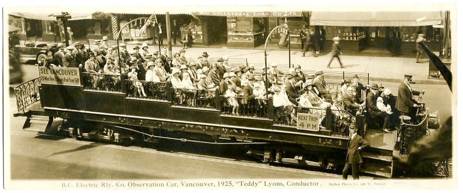
B.C. Electric Railway Co. Observation Car
https://search.heritageburnaby.ca/link/museumdescription3711
- Repository
- Burnaby Village Museum
- Date
- 1925
- Collection/Fonds
- Harold Edward Winch collection
- Description Level
- Item
- Physical Description
- 1 photograph : sepia ; 9.6 x 23.6 cm
- Scope and Content
- Item is a photographic postcard of an open sightseeing car operated by the BC Electric Railway Company. The car is full of people and travelling down in a street in Vancouver with B.C. Electric conductor Teddy Lyons at the controls at the head of the car and another conductor standing next to the …
- Repository
- Burnaby Village Museum
- Collection/Fonds
- Harold Edward Winch collection
- Description Level
- Item
- Physical Description
- 1 photograph : sepia ; 9.6 x 23.6 cm
- Scope and Content
- Item is a photographic postcard of an open sightseeing car operated by the BC Electric Railway Company. The car is full of people and travelling down in a street in Vancouver with B.C. Electric conductor Teddy Lyons at the controls at the head of the car and another conductor standing next to the car.
- Subjects
- Transportation - Electric Railroads
- Geographic Access
- Vancouver
- Accession Code
- BV013.12.68
- Date
- 1925
- Media Type
- Photograph
- Photographer
- Bullen, Harry Elder
- Notes
- Title based on contents of photograph
- Photograph is a part of original scrapbook Item BV013.12.11
- Inscription below photograph reads: "B.C. Electric Rly. Co. Observation Car, Vancouver, 1925, "Teddy" Lyons Conductor_Bullen Photo Co. 626 W. Pender."
Images
![East Burnaby United Church, [ca.1925] thumbnail](/media/hpo/_Data/_BVM_Cartographic_Material/2003/2003_0083_0054_001.jpg?width=280)
East Burnaby United Church
https://search.heritageburnaby.ca/link/museumdescription11932
- Repository
- Burnaby Village Museum
- Date
- [ca.1925]
- Collection/Fonds
- Ronald G. Scobbie collection
- Description Level
- Item
- Physical Description
- 1 plan : black ink and watercol. on paper ; 30.45 x 30.5 cm
- Scope and Content
- Item consists of a building insurance plan of "East Burnaby United Church / Lot 1 BK 2 south Part DL 28 GP 1 N.W.D.". Twelfth Avenue is identified to the north and Douglas Road to the west.
- Repository
- Burnaby Village Museum
- Collection/Fonds
- Ronald G. Scobbie collection
- Description Level
- Item
- Physical Description
- 1 plan : black ink and watercol. on paper ; 30.45 x 30.5 cm
- Material Details
- Scale 1 inch = 20 feet
- Scope and Content
- Item consists of a building insurance plan of "East Burnaby United Church / Lot 1 BK 2 south Part DL 28 GP 1 N.W.D.". Twelfth Avenue is identified to the north and Douglas Road to the west.
- Subjects
- Buildings - Religious - Churches
- Accession Code
- BV003.83.54
- Access Restriction
- No restrictions
- Reproduction Restriction
- No known restrictions
- Date
- [ca.1925]
- Media Type
- Cartographic Material
- Scan Resolution
- 600
- Scan Date
- 15-Jan-2021
- Scale
- 100
- Notes
- Transcribed title
- Note in pencil on verso reads: "East Burnaby United Church / Lot 1 BK 2 south Part DL 28 / 1" = 20' "
- Note in black ink on verso reads: "3704"
Images
![East Burnaby United Church, [ca.1925] thumbnail](/media/hpo/_Data/_BVM_Cartographic_Material/2003/2003_0083_0054_001.jpg)
![Firefighter Albert Killer behind the wheel, [1925] (date of original) thumbnail](/media/hpo/_Data/_BVM_Images/1990/199800310006.jpg?width=280)
Firefighter Albert Killer behind the wheel
https://search.heritageburnaby.ca/link/museumdescription1297
- Repository
- Burnaby Village Museum
- Date
- [1925] (date of original)
- Collection/Fonds
- Burnaby Village Museum Photograph collection
- Description Level
- Item
- Physical Description
- 1 photograph : b&w ; 10 x 15 cm print
- Scope and Content
- Photograph of Firefighter Albert Killer behind the wheel of the second fire truck in North Burnaby. It was a 4 cylinder Dodge combination hose and chemical truck.
- Repository
- Burnaby Village Museum
- Collection/Fonds
- Burnaby Village Museum Photograph collection
- Description Level
- Item
- Physical Description
- 1 photograph : b&w ; 10 x 15 cm print
- Scope and Content
- Photograph of Firefighter Albert Killer behind the wheel of the second fire truck in North Burnaby. It was a 4 cylinder Dodge combination hose and chemical truck.
- Accession Code
- BV998.31.6
- Access Restriction
- No restrictions
- Reproduction Restriction
- No known restrictions
- Date
- [1925] (date of original)
- Media Type
- Photograph
- Scan Resolution
- 600
- Scan Date
- 01-Jun-09
- Scale
- 100
- Photographer
- Blake, Frederick "Fred"
- Notes
- Title based on contents of photograph
- Typed sticker on verso of photograph reads: "First North Burnaby fire engine. Albert Killer on 1925 DODGE combination hose and chemical truck. 4 cyl."
- Address sticker on verso of photograph reads: "MR & MRS F BLAKE 4165 PANDORA ST BURNABY BC V5C 2B2"
Images
![Firefighter Albert Killer behind the wheel, [1925] (date of original) thumbnail](/media/hpo/_Data/_BVM_Images/1990/199800310006.jpg)
![Fire hall no. 1, [1925] (date of original) thumbnail](/media/hpo/_Data/_BVM_Images/1990/199800310005.jpg?width=280)
Fire hall no. 1
https://search.heritageburnaby.ca/link/museumdescription1296
- Repository
- Burnaby Village Museum
- Date
- [1925] (date of original)
- Collection/Fonds
- Burnaby Village Museum Photograph collection
- Description Level
- Item
- Physical Description
- 1 photograph : b&w ; 10 x 15 cm print
- Scope and Content
- Photograph of North Burnaby's first fire hall (the building was originally used as a pump house before it was converted).
- Repository
- Burnaby Village Museum
- Collection/Fonds
- Burnaby Village Museum Photograph collection
- Description Level
- Item
- Physical Description
- 1 photograph : b&w ; 10 x 15 cm print
- Scope and Content
- Photograph of North Burnaby's first fire hall (the building was originally used as a pump house before it was converted).
- Subjects
- Buildings - Civic - Fire Halls
- Names
- Burnaby Fire Department
- Geographic Access
- Carleton Avenue
- Eton Street
- Accession Code
- BV998.31.5
- Access Restriction
- No restrictions
- Reproduction Restriction
- No known restrictions
- Date
- [1925] (date of original)
- Media Type
- Photograph
- Historic Neighbourhood
- Vancouver Heights (Historic Neighbourhood)
- Planning Study Area
- Burnaby Heights Area
- Scan Resolution
- 600
- Scan Date
- 01-Jun-09
- Scale
- 100
- Photographer
- Blake, Frederick "Fred"
- Notes
- Title based on contents of photograph
- Typed sticker on verso of photograph reads: "Burnaby's first fire hall Carleton Ave. and Eton St. 290 N (1925)"
- Address sticker on verso of photograph reads: "MR & MRS F BLAKE 4165 PANDORA ST BURNABY BC V5C 2B2"
Images
![Fire hall no. 1, [1925] (date of original) thumbnail](/media/hpo/_Data/_BVM_Images/1990/199800310005.jpg)
![St. Margaret's Anglican Mission, [1929] thumbnail](/media/hpo/_Data/_BVM_Cartographic_Material/2003/2003_0083_0050_001.jpg?width=280)
St. Margaret's Anglican Mission
https://search.heritageburnaby.ca/link/museumdescription11928
- Repository
- Burnaby Village Museum
- Date
- [1929]
- Collection/Fonds
- Ronald G. Scobbie collection
- Description Level
- Item
- Physical Description
- 1 plan : black ink and watercol. on paper ; 30.45 x 30.5 cm
- Scope and Content
- Item consists of building insurance plan for St. Margaret of Scotland Anglican Church. Title of plan reads: "St. Margaret's Anglican Mission (note:"Church" has been crossed out and corrected with "Mission") / Lot 10, DL 132 / GP1 N.W.D." . Curtis Street is identified to the north and Sperling Av…
- Repository
- Burnaby Village Museum
- Collection/Fonds
- Ronald G. Scobbie collection
- Description Level
- Item
- Physical Description
- 1 plan : black ink and watercol. on paper ; 30.45 x 30.5 cm
- Material Details
- Scale 1 inch = 40 feet
- Scope and Content
- Item consists of building insurance plan for St. Margaret of Scotland Anglican Church. Title of plan reads: "St. Margaret's Anglican Mission (note:"Church" has been crossed out and corrected with "Mission") / Lot 10, DL 132 / GP1 N.W.D." . Curtis Street is identified to the north and Sperling Ave. to the west.
- Subjects
- Buildings - Religious - Churches
- Geographic Access
- Sperling Avenue
- Curtis Street
- Accession Code
- BV003.83.50
- Access Restriction
- No restrictions
- Reproduction Restriction
- No known restrictions
- Date
- [1929]
- Media Type
- Cartographic Material
- Scan Resolution
- 600
- Scan Date
- 15-Jan-2021
- Scale
- 100
- Notes
- Transcribed title
- Note in pencil on verso reads: "St. Margaret's Anglican Mission / Lot 10, DL 132 / 1" = 40' "
- Note in balck in on verso reads: "3704"
Images
![St. Margaret's Anglican Mission, [1929] thumbnail](/media/hpo/_Data/_BVM_Cartographic_Material/2003/2003_0083_0050_001.jpg)
![St. Nicolas Parish Church, [ca.1912] thumbnail](/media/hpo/_Data/_BVM_Cartographic_Material/2003/2003_0083_0053_001.jpg?width=280)
St. Nicolas Parish Church
https://search.heritageburnaby.ca/link/museumdescription11931
- Repository
- Burnaby Village Museum
- Date
- [ca.1912]
- Collection/Fonds
- Ronald G. Scobbie collection
- Description Level
- Item
- Physical Description
- 1 plan : black ink and watercol. on paper ; 30.45 x 30.5 cm
- Scope and Content
- Item consists of a building insurance plan of St. Nicholas Anglican Church. Title on plan reads "St. Nicolas [sic] Parish Church / Lots 11 & 12 BK 10 DL 186 GP 1 / N.W.D.". Ingleton Avenue is identified to the east and Triumph Street to the south.
- Repository
- Burnaby Village Museum
- Collection/Fonds
- Ronald G. Scobbie collection
- Description Level
- Item
- Physical Description
- 1 plan : black ink and watercol. on paper ; 30.45 x 30.5 cm
- Material Details
- Scale 1 inch = 20 feet
- Scope and Content
- Item consists of a building insurance plan of St. Nicholas Anglican Church. Title on plan reads "St. Nicolas [sic] Parish Church / Lots 11 & 12 BK 10 DL 186 GP 1 / N.W.D.". Ingleton Avenue is identified to the east and Triumph Street to the south.
- Subjects
- Buildings - Religious - Churches
- Geographic Access
- Triumph Street
- Street Address
- 3883 Triumph Street
- Accession Code
- BV003.83.53
- Access Restriction
- No restrictions
- Reproduction Restriction
- No known restrictions
- Date
- [ca.1912]
- Media Type
- Cartographic Material
- Historic Neighbourhood
- Vancouver Heights (Historic Neighbourhood)
- Scan Resolution
- 600
- Scan Date
- 15-Jan-2021
- Scale
- 100
- Notes
- Transcribed title
- Note in pencil on verso reads: "St. Nicholas Parish Church / Lots 11 & 12 BK 10 DL 186 / 1" = 20' "
- Note in black ink on verso reads: "3704"
Images
![St. Nicolas Parish Church, [ca.1912] thumbnail](/media/hpo/_Data/_BVM_Cartographic_Material/2003/2003_0083_0053_001.jpg)