Narrow Results By

Jubilee Grove Arch
https://search.heritageburnaby.ca/link/landmark533
- Repository
- Burnaby Heritage Planning
- Description
- The Jubilee Grove Arch sits at the corner of Kingsway and Patterson Avenue. Located within Central Park, the ceremonial arch and its decorative plantings provide a visual anchor to the northeast corner and entry point to the park.
- Associated Dates
- 1939
- Formal Recognition
- Heritage Designation, Community Heritage Register
- Street View URL
- Google Maps Street View
- Repository
- Burnaby Heritage Planning
- Geographic Access
- Imperial Street
- Associated Dates
- 1939
- Formal Recognition
- Heritage Designation, Community Heritage Register
- Enactment Type
- Bylaw No. 9807
- Enactment Date
- 23/11/1992
- Description
- The Jubilee Grove Arch sits at the corner of Kingsway and Patterson Avenue. Located within Central Park, the ceremonial arch and its decorative plantings provide a visual anchor to the northeast corner and entry point to the park.
- Heritage Value
- Jubilee Grove Arch was dedicated as part of the municipality’s celebration of the Jubilee of the coronation of King George V and was dedicated during Burnaby’s annual May Day celebrations in 1935. Much of the construction work was carried out by local citizens under the direction of the Burnaby Engineering Department through a Depression era work relief program that provided a way for local residents to pay their taxes. The garden was also chosen as the site for the ceremonial planting of an oak tree from the Royal Forest at Windsor, in honor of the Coronation of King George VI and Queen Elizabeth in 1937. The original bronze garden dedication plaque and oak tree remain at the site today. The decorative stone arch was erected in 1939 as a symbol of Burnaby's, and the Lower Mainland of British Columbia’s, strong ties to the English monarchy at the time, and the arch’s unveiling during May Day ceremonies shows the social role that such a commemorative feature played both to the local government and people of Burnaby. It was erected just prior to the Royal Visit of 1939, the first time that reigning British monarchs had travelled to Canada. Built of Haddington Island sandstone, the arch itself was reconstructed from a salvaged architectural element of a historic Vancouver landmark. The arch originally framed the entrance door to the Vancouver Club building in Vancouver, built in 1893-94 on West Hastings Street and designed by architect C.O. Wickenden. The building was demolished in 1930, however the arch was stored and rebuilt as the focal point of the Jubilee Grove after being bought by the Municipality of Burnaby. The work was undertaken by Italian-born stone mason Rizieri Stefanini (1879-1954), the owner of Burnaby Monumental Works. The re-use of the arch symbolizes the close tie between Vancouver and Burnaby and the joint evolution of the neighbouring cities.
- Defining Elements
- The Jubilee Grove Arch has character-defining elements that recognize it both as a remnant of a past building and as a new and individual structure. These include its: - axial diagonal placement and prominent corner location marking one of the entries to Central Park - visibility and accessibility as a public monument - hand carved stone blocks of Haddington Island sandstone - decorative twisted-rope motif carved to outline the arch - supporting rusticated sidewalls with planting urns - original bronze dedication plaque - flanking ornamental gardens - Royal Oak tree and plaque
- Historic Neighbourhood
- Central Park (Historic Neighbourhood)
- Planning Study Area
- Maywood Area
- Organization
- City of Burnaby
- Architect
- C.O. Wickenden
- Function
- Primary Current--Park Fixture
- Primary Historic--Park Fixture
- Community
- Burnaby
- Cadastral Identifier
- P.I.D. No. 017-767-172 Legal Description: Block B of Lot 2 Except Firstly: Part on Plan 8669 and Secondly: Part on Plan LMP4689 District Lot 151, Group 1, New Westminster District, Plan 3443
- Boundaries
- The property (Central Park) is a municipally-owned park that lies at the western edge of Burnaby, between 49th Avenue to the south, Kingsway to the north, Boundary Road to the west and Patterson Avenue to the east.
- Area
- 853,403.82
- Contributing Resource
- Structure
- Landscape Feature
- Ownership
- Public (local)
- Documentation
- Heritage Site Files: PC77000 20. City of Burnaby Planning and Building Department, 4949 Canada Way, Burnaby, B.C., V5G 1M2
- Names
- Burnaby Monumental Works
- Street Address
- 3883 Imperial Street
- Street View URL
- Google Maps Street View
Images


History of Burnaby Resource Guide
https://search.heritageburnaby.ca/link/museumlibrary7492
- Repository
- Burnaby Village Museum
- Author
- Burnaby Village Museum
- Publication Date
- 2019
Available as an eBook online at HeritageBurnaby.ca
Available at Burnaby Public Library: 971.133 Int
Available at Burnaby Public Library: 971.133 Lux
Burnaby’s Heritage: An Inventory of Buildings and Structures.
Donald Luxton and Jim Wolf. Burnaby: City of Burnaby, c2007.
Available at the Burnaby Village
- Repository
- Burnaby Village Museum
- Collection
- Digital Reference Collection
- Material Type
- Digital Resource
- Accession Code
- BV019.63.1
- Author
- Burnaby Village Museum
- Place of Publication
- Burnaby, BC
- Publisher
- City of Burnaby
- Publication Date
- 2019
- Physical Description
- 21 p. : ill.
- Library Subject (LOC)
- Burnaby (B.C.)--History
- Directories
- Object History
- Created from research gathered by Burnaby Village Museum staff into the diverse History of Burnaby.
Images

Digital Books

Indigenous History in Burnaby Resource Guide
https://search.heritageburnaby.ca/link/museumlibrary7493
- Repository
- Burnaby Village Museum
- Collection
- Digital Reference Collection
- Material Type
- Digital Resource
- Accession Code
- BV019.64.1
- Call Number
- 971.100497 BVM
- Edition
- First
- Contributor
- Kwantlen First Nation
- Sḵwx̱wú7mesh First Nation
- Tsleil-Waututh First Nation
- ʷməθkʷəy̓əm (Musqueam) First Nation
- Place of Publication
- Burnaby, BC
- Publisher
- City of Burnaby
- Publication Date
- 2019
- Library Subject (LOC)
- Indigenous peoples--British Columbia
- Indigenous peoples--British Columbia--History
- Indigenous peoples--Canada--History
- Subjects
- Indigenous peoples - British Columbia
- Indigenous peoples - British Columbia - Languages
- Indigenous peoples - British Columbia - Societies, etc.
- Name Access
- Burnaby Village Museum
- Object History
- 2019 version of working document developed by Burnaby Village Museum in collaboration with a number of First Nations partners over the course of several years. We recognize that Burnaby falls within the shared, ancestral and unceded territories of the hən̓q̓əmin̓əm and Sḵwx̱wú7mesh speaking people. We equally respect each of the Nations who share territory in Burnaby, and invite and welcome their ongoing participation in developing the contents of the Indigenous History in Burnaby Resource Guide.
Images

Digital Books
Construction of stage 4 at Bridge Studios
https://search.heritageburnaby.ca/link/museumdescription19269
- Repository
- Burnaby Village Museum
- Date
- May 1995
- Collection/Fonds
- George Bergson fonds
- Description Level
- Item
- Physical Description
- 1 photograph : col. negative ; 35 mm
- Scope and Content
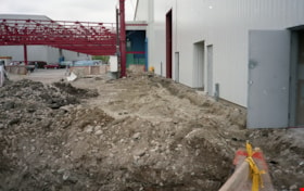
- Photograph of construction of new stage 4, looking west north side at Bridge Studios. Excavated area next and red steel structure for building are visible. Bridge Studios is located at 2400 Boundary Road Burnaby.
- Repository
- Burnaby Village Museum
- Collection/Fonds
- George Bergson fonds
- Description Level
- Item
- Physical Description
- 1 photograph : col. negative ; 35 mm
- Scope and Content
- Photograph of construction of new stage 4, looking west north side at Bridge Studios. Excavated area next and red steel structure for building are visible. Bridge Studios is located at 2400 Boundary Road Burnaby.
- Names
- Bridge Studios
- Accession Code
- BV022.28.15
- Access Restriction
- No restrictions
- Reproduction Restriction
- No known restrictions
- Date
- May 1995
- Media Type
- Photograph
- Scan Resolution
- 3200
- Scan Date
- 2022-03-22
- Scale
- 100
- Photographer
- Bergson, George
- Notes
- Title based on contents of photograph
- Photographer George Bergson negative #: "33098_2"
Images

Interior of tilt up building at Bridge Studios
https://search.heritageburnaby.ca/link/museumdescription19271
- Repository
- Burnaby Village Museum
- Date
- May 1995
- Collection/Fonds
- George Bergson fonds
- Description Level
- Item
- Physical Description
- 1 photograph : col. negative ; 35 mm
- Scope and Content
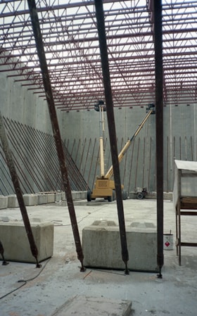
- Photograph of interior of tilt up building under construction at Bridge Studios. Concrete slab, concrete blocks, red steel structure and two hydraulic articulated boom lifts are visible. Bridge Studios is located at 2400 Boundary Road Burnaby.
- Repository
- Burnaby Village Museum
- Collection/Fonds
- George Bergson fonds
- Description Level
- Item
- Physical Description
- 1 photograph : col. negative ; 35 mm
- Scope and Content
- Photograph of interior of tilt up building under construction at Bridge Studios. Concrete slab, concrete blocks, red steel structure and two hydraulic articulated boom lifts are visible. Bridge Studios is located at 2400 Boundary Road Burnaby.
- Names
- Bridge Studios
- Accession Code
- BV022.28.17
- Access Restriction
- No restrictions
- Reproduction Restriction
- No known restrictions
- Date
- May 1995
- Media Type
- Photograph
- Scan Resolution
- 3200
- Scan Date
- 2022-03-22
- Scale
- 100
- Photographer
- Bergson, George
- Notes
- Title based on contents of photograph
- Photographer George Bergson negative #: "33011_3"
Images
