Narrow Results By
British Columbia Police
https://search.heritageburnaby.ca/link/archivedescription34562
- Repository
- City of Burnaby Archives
- Date
- May 7, 1949
- Collection/Fonds
- Burnaby Historical Society fonds
- Description Level
- Item
- Physical Description
- 1 photograph : b&w ; 19.2 x 24.6 cm mounted on 30.4 x 35.5 cm cardboard
- Scope and Content
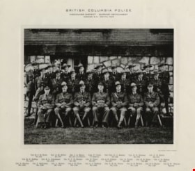
- Photograph of the British Columbia Provincial Police, Burnaby Detachment at Burnaby Municipal Hall. The caption above the photograph reads, "British Columbia Police / Vancouver District - Burnaby Detachment / Burnaby, B.C. - May 7th, 1949. The members are, front row, left to right: Cpl. R.C.B Foo…
- Repository
- City of Burnaby Archives
- Date
- May 7, 1949
- Collection/Fonds
- Burnaby Historical Society fonds
- Subseries
- Photographs subseries
- Physical Description
- 1 photograph : b&w ; 19.2 x 24.6 cm mounted on 30.4 x 35.5 cm cardboard
- Description Level
- Item
- Record No.
- 049-001
- Access Restriction
- No restrictions
- Reproduction Restriction
- Reproduce for fair dealing purposes only
- Accession Number
- BHS2007-04
- Scope and Content
- Photograph of the British Columbia Provincial Police, Burnaby Detachment at Burnaby Municipal Hall. The caption above the photograph reads, "British Columbia Police / Vancouver District - Burnaby Detachment / Burnaby, B.C. - May 7th, 1949. The members are, front row, left to right: Cpl. R.C.B Foote (No. 215), Cpl. A.M. Millar (No. 575), Sgt. J.A. Henry (No. 414 i/c Detach.), Insp. C. Clark (i/c District), Det./Cpl. G.J. Emsley (No. 509), Cpl. G.S. Pearson (No. 579), and Cst. C.E. Estlin (No. 914). Middle row, left to right: Cst. R.G. McKay (No. 1071), Cst. B.L. Johannson (No. 1019), Cst. N.C.B. Nelson (No. 733), Cst. H. Twist (No. 607), Cst. A.E. Gibbon (No. 947), Cst. E. Turtle (No. 959), Cst. H.E. Klick (No. 923), and Cst. J.H. Bishop (No. 1031). Back row, left to right: Cst. S. Service (No. 1152), Cst. J. McCowan (No. 1133), Cst. L. Brown (No. 1150), Cst. J.E. Clark (No. 1142), Cst. L.J. Tabbutt (No. 1053), Cst. V.H. St. Pierce (No. 1153), Cst. D.N. Brown (No. 1149), Cst. B.O. Mayne (No. 1136), and Cst. Q.W. Wenaus (Special).
- Names
- Bishop, J.H.
- British Columbia Provincial Police
- Brown, Donald N. "Don"
- Brown, L.
- Clark, J.E.
- Clarke, C.
- Emsley, G.J.
- Estlin, C.E.
- Foote, R.C.B.
- Gibbon, A.E.
- Henry, J.A.
- Johannson, B.L.
- Klick, H.E.
- Mayne, B.O.
- McCowan, J.
- McKay, R.G.
- Millar, A.M.
- Nelson, N.C.B.
- Pearson, G.S.
- Service, S.
- St. Pierce, V.H.
- Tabbutt, L.J.
- Turtle, Eric
- Twist, H.
- Wenaus, Q.W.
- Media Type
- Photograph
- Photographer
- Balkin, Jack
- Geographic Access
- Kingsway
- Street Address
- 7282 Kingsway
- Historic Neighbourhood
- Edmonds (Historic Neighbourhood)
- Planning Study Area
- Stride Avenue Area
Images

![Edmonds School United Nations flag, [195-] thumbnail](/media/hpo/_Data/_Archives_Images/_Unrestricted/126/138-007.jpg?width=280)
Edmonds School United Nations flag
https://search.heritageburnaby.ca/link/archivedescription34816
- Repository
- City of Burnaby Archives
- Date
- [195-]
- Collection/Fonds
- Burnaby Historical Society fonds
- Description Level
- Item
- Physical Description
- 1 photograph : b&w ; 20.6 x 25.4 cm
- Scope and Content
- Photograph of the Edmonds School United Nations flag. Four young women and two men are unfolding it. Identified: Jack Davy (left) and Bill Good (right).
- Repository
- City of Burnaby Archives
- Date
- [195-]
- Collection/Fonds
- Burnaby Historical Society fonds
- Subseries
- Helen Davy subseries
- Physical Description
- 1 photograph : b&w ; 20.6 x 25.4 cm
- Description Level
- Item
- Record No.
- 138-007
- Access Restriction
- No restrictions
- Reproduction Restriction
- Reproduce for fair dealing purposes only
- Accession Number
- BHS1985-08
- Scope and Content
- Photograph of the Edmonds School United Nations flag. Four young women and two men are unfolding it. Identified: Jack Davy (left) and Bill Good (right).
- Subjects
- Symbols - Flags
- Officials
- Media Type
- Photograph
- Photographer
- Allan, Ray
- Notes
- Title based on contents of photograph
- Stamp on back of photograph reads, "Ray Allan / The Allan Studios / 3763 Kingsway, Burnaby, BC / Phone: Dex. 5766"
- Geographic Access
- Edmonds Street
- Street Address
- 7641 Edmonds Street
- Historic Neighbourhood
- Edmonds (Historic Neighbourhood)
- Planning Study Area
- Edmonds Area
Images
![Edmonds School United Nations flag, [195-] thumbnail](/media/hpo/_Data/_Archives_Images/_Unrestricted/126/138-007.jpg)
![Edmonds School United Nations flag, [195-] thumbnail](/media/hpo/_Data/_Archives_Images/_Unrestricted/126/138-008.jpg?width=280)
Edmonds School United Nations flag
https://search.heritageburnaby.ca/link/archivedescription34817
- Repository
- City of Burnaby Archives
- Date
- [195-]
- Collection/Fonds
- Burnaby Historical Society fonds
- Description Level
- Item
- Physical Description
- 1 photograph : b&w ; 20.6 x 25.4 cm
- Scope and Content
- Photograph of the Edmonds School United Nations flag and officials. Identified (on back of photograph): Jack Davy, C.G. Brown, and Bill Good.
- Repository
- City of Burnaby Archives
- Date
- [195-]
- Collection/Fonds
- Burnaby Historical Society fonds
- Subseries
- Helen Davy subseries
- Physical Description
- 1 photograph : b&w ; 20.6 x 25.4 cm
- Description Level
- Item
- Record No.
- 138-008
- Access Restriction
- No restrictions
- Reproduction Restriction
- Reproduce for fair dealing purposes only
- Accession Number
- BHS1985-08
- Scope and Content
- Photograph of the Edmonds School United Nations flag and officials. Identified (on back of photograph): Jack Davy, C.G. Brown, and Bill Good.
- Subjects
- Symbols - Flags
- Officials
- Media Type
- Photograph
- Photographer
- Allan, Ray
- Notes
- Title based on contents of photograph
- Stamp on back of photograph reads, "Ray Allan / The Allan Studios / 3763 Kingsway, Burnaby, BC / Phone: Dex. 5766"
- Geographic Access
- Edmonds Street
- Street Address
- 7641 Edmonds Street
- Historic Neighbourhood
- Edmonds (Historic Neighbourhood)
- Planning Study Area
- Edmonds Area
Images
![Edmonds School United Nations flag, [195-] thumbnail](/media/hpo/_Data/_Archives_Images/_Unrestricted/126/138-008.jpg)

Municipality of Burnaby- Volume XV and Volume XVIII
https://search.heritageburnaby.ca/link/museumdescription8686
- Repository
- Burnaby Village Museum
- Date
- May 1927
- Collection/Fonds
- Burnaby Village Museum Map collection
- Description Level
- File
- Physical Description
- 4 plans on 4 sheets : col. lithographic prints ; 63.5 x 53.5 cm folded to 53 x 31.5 cm
- Scope and Content
- File consists of four pages of plans removed from a bound book containing a series of fire insurance plans of the Municipality of Burnaby. Plan "1520" is part of "GREATER VANCOUVER B.C. / VOLUME XV / Municipality of Burnaby / May 1927" and covers District Lots: 121 and 187. Plann "1521" is part of …
- Repository
- Burnaby Village Museum
- Collection/Fonds
- Burnaby Village Museum Map collection
- Description Level
- File
- Physical Description
- 4 plans on 4 sheets : col. lithographic prints ; 63.5 x 53.5 cm folded to 53 x 31.5 cm
- Material Details
- Scale [1:600] and [1:1200]
- Scope and Content
- File consists of four pages of plans removed from a bound book containing a series of fire insurance plans of the Municipality of Burnaby. Plan "1520" is part of "GREATER VANCOUVER B.C. / VOLUME XV / Municipality of Burnaby / May 1927" and covers District Lots: 121 and 187. Plann "1521" is part of "GREATER VANCOUVER B.C. / VOLUME XV / Municipality of Burnaby / May 1927" and covers District Lots: 121 and 187. Key plan "H" reads: "GREATER VANCOUVER B.C. / VOLUME XVIII / Surveyed _ May 1927 / MUNICIPALITY OF / BURNABY" and covers plans: 1813 to 1822; 1824 to 1832; 1839; 1840; 1853 to 1865 and District Lots: 28; 30; 53; 90 to 93; 95 to 97; 155a; 155b; 155c; 159; 160; 171 to 173. Plan "1801" is part of "GREATER VANCOUVER B.C. / VOLUME XVIII / Municipality of Burnaby / May 1927" and covers District Lot 153.
- Responsibility
- British Columbia Underwriters' Association
- Accession Code
- HV972.111.8
- Access Restriction
- No restrictions
- Reproduction Restriction
- May be restricted by third party rights
- Date
- May 1927
- Media Type
- Cartographic Material
- Historic Neighbourhood
- Fraser Arm (Historic Neighbourhood)
- Vancouver Heights (Historic Neighbourhood)
- East Burnaby (Historic Neighbourhood)
- Edmonds (Historic Neighbourhood)
- Planning Study Area
- Marlborough Area
- Kingsway-Beresford Area
- Windsor Area
- Big Bend Area
- Clinton-Glenwood Area
- Burnaby Heights Area
- Edmonds Area
- Stride Avenue Area
- Scan Resolution
- 400
- Scan Date
- 2021-11-18
- Notes
- Title based on content of plans
- See also BV987.1.70d for revised versions of plans
- Scale is measured 1 inch = 500 feet
Zoomable Images


Municipality of Burnaby - Volume XVIII
https://search.heritageburnaby.ca/link/museumdescription8687
- Repository
- Burnaby Village Museum
- Date
- May 1927
- Collection/Fonds
- Burnaby Village Museum Map collection
- Description Level
- File
- Physical Description
- 2 plans on 2 sheets : col. lithographic prints; 63.5 x 53.5 cm folded to 53 x 31.5 cm
- Scope and Content
- File consists of two pages of plans removed from a bound book containing a series of fire insurance plans of the Municipality of Burnaby. Plan "1819" and Plan "1820 are part of "GREATER VANCOUVER B.C. / VOLUME XVIII / Municipality of Burnaby / May 1927. Plan "1819" covers District Lot 95 and plan …
- Repository
- Burnaby Village Museum
- Collection/Fonds
- Burnaby Village Museum Map collection
- Description Level
- File
- Physical Description
- 2 plans on 2 sheets : col. lithographic prints; 63.5 x 53.5 cm folded to 53 x 31.5 cm
- Material Details
- Scales [1:600]
- Scope and Content
- File consists of two pages of plans removed from a bound book containing a series of fire insurance plans of the Municipality of Burnaby. Plan "1819" and Plan "1820 are part of "GREATER VANCOUVER B.C. / VOLUME XVIII / Municipality of Burnaby / May 1927. Plan "1819" covers District Lot 95 and plan "1820" covers District Lots 30 and 95.
- Responsibility
- British Columbia Underwriters' Association
- Accession Code
- HV972.111.38
- Access Restriction
- No restrictions
- Reproduction Restriction
- May be restricted by third party rights
- Date
- May 1927
- Media Type
- Cartographic Material
- Historic Neighbourhood
- Edmonds (Historic Neighbourhood)
- Highland Park (Historic Neighbourhood)
- Planning Study Area
- Stride Hill Area
- Kingsway-Beresford Area
- Scan Resolution
- 400
- Scan Date
- 2021-11-18
- Notes
- Title based on content of plans
- Scales are measured 1 inch = 50 feet
- See also BV987.1.70d for revised versions of plans
Images


Municipality of Burnaby - Volume XV, Volume XVI, Volume XVII, Volume XVIII
https://search.heritageburnaby.ca/link/museumdescription8685
- Repository
- Burnaby Village Museum
- Date
- May 1927
- Collection/Fonds
- Burnaby Village Museum Map collection
- Description Level
- File
- Physical Description
- 4 plans on 4 sheets : col. lithographic prints ; 63.5 x 53.5 cm folded to 53 x 31.5 cm
- Scope and Content
- File consists of four pages of plans removed from a bound book containing a series of fire insurance plans of the Municipality of Burnaby. Plan "1531" is part of "GREATER VANCOUVER B.C. / VOLUME XV / Municipality of Burnaby / May 1927" and covers District Lots: 116 and 117. Key Plan "C" is part of …
- Repository
- Burnaby Village Museum
- Collection/Fonds
- Burnaby Village Museum Map collection
- Description Level
- File
- Physical Description
- 4 plans on 4 sheets : col. lithographic prints ; 63.5 x 53.5 cm folded to 53 x 31.5 cm
- Material Details
- Scale [1:600] and [1:1200]
- Scope and Content
- File consists of four pages of plans removed from a bound book containing a series of fire insurance plans of the Municipality of Burnaby. Plan "1531" is part of "GREATER VANCOUVER B.C. / VOLUME XV / Municipality of Burnaby / May 1927" and covers District Lots: 116 and 117. Key Plan "C" is part of "GREATER VANCOUVER B.C. / VOLUME XVI / Municipality of Burnaby / May 1927" and covers plans 1623 to 1651 and District Lots: 1 and 2; 4; 6; 8; 10 to 14; 25; 27; 40; 56 to 58; 88 and 89. Plan "1738" is part of "GREATER VANCOUVER B.C. / VOLUME XVII / Municipality of Burnaby / May 1927" and covers District Lots: 34 and 35. Key plan "G" is part of "GREATER VANCOUVER B.C. / VOLUME XVIII / Municipality of Burnaby / May 1927" and covers plans: 1801 to 1813; 1823; 1824; 1833 to 1838; 1841 to 1853 and District Lots: 32; 93; 94; 97 to 99; 149; 150; 152; 155 to 159; 161 to 164.
- Responsibility
- British Columbia Underwriters' Association
- Accession Code
- HV972.111.7
- Access Restriction
- No restrictions
- Reproduction Restriction
- May be restricted by third party rights
- Date
- May 1927
- Media Type
- Cartographic Material
- Historic Neighbourhood
- Central Park (Historic Neighbourhood)
- Fraser Arm (Historic Neighbourhood)
- Alta Vista (Historic Neighbourhood)
- Broadview (Historic Neighbourhood)
- Vancouver Heights (Historic Neighbourhood)
- Burquitlam (Historic Neighbourhood)
- East Burnaby (Historic Neighbourhood)
- Edmonds (Historic Neighbourhood)
- Lozells (Historic Neighbourhood)
- Planning Study Area
- Clinton-Glenwood Area
- Marlborough Area
- Maywood Area
- Windsor Area
- Big Bend Area
- Garden Village Area
- Willingdon Heights Area
- West Central Valley Area
- Cariboo-Armstrong Area
- Lyndhurst Area
- Cameron Area
- Lake City Area
- Edmonds Area
- Second Street Area
- Sperling-Broadway Area
- Lakeview-Mayfield Area
- Scan Resolution
- 400
- Scan Date
- 2021-11-18
- Notes
- Title based on content of plans
- See also BV987.1.70d for revised versions of plans
- Scale is measured 1 inch = 500 feet
Zoomable Images

Municipality of Burnaby - Volume XV, Volume XVI, Volume XVII, Volume XVIII, May 1927
Zoom into Image