Narrow Results By
Creator
- Albert F. Arnold
- Bartel, Mario 33
- Bellinger, Bernard 2
- Bowman & Cullerne 1
- British Columbia Underwriters' Association 3
- Burnett and McGugan B.C. Land Surveyors, New Westminster 1
- Burnett & McGugan, Engineers and Surveyors 1
- Cheung, Nakita 2
- Cook, Alan 5
- Digney, Andy 4
- Disney, John Harold "Jack"
- Flanagan, Colleen 1

Ocean View Burial Park - Landscape
https://search.heritageburnaby.ca/link/landmark629
- Repository
- Burnaby Heritage Planning
- Description
- Cemetery site.
- Associated Dates
- 1919
- Street View URL
- Google Maps Street View
- Repository
- Burnaby Heritage Planning
- Geographic Access
- Imperial Street
- Associated Dates
- 1919
- Description
- Cemetery site.
- Heritage Value
- Burnaby’s landmark Ocean View Burial Park was British Columbia’s first non-sectarian cemetery created as a for-profit business enterprise. Organized by a group of local investors headed by Lieut. Col. G.H. Dorrell, the Ocean View Cemetery Company offered a place for burials that was not owned or associated with a civic government, religious or fraternal organization. The cemetery’s design was the vision of Albert F. Arnold, an officer of the Canadian Financiers Trust Company, who was “...always depressed by the lack of beauty in so many places of internment and inevitable neglect that finally reduced them to long-grassed places of unhappy memories.” One local newspaper described the landscape of the cemetery: "The design includes ornamental trees and shrubs, beautiful flower beds and smooth winding walks and drives, with a total absence of the usual somewhat ostentatious reminders of the harvest garnered by the grim reaper."
- Locality
- Alta Vista
- Historic Neighbourhood
- Alta Vista (Historic Neighbourhood)
- Planning Study Area
- Suncrest Area
- Architect
- Albert F. Arnold
- Area
- 359280.00
- Contributing Resource
- Landscape Feature
- Ownership
- Private
- Street Address
- 4000 Imperial Street
- Street View URL
- Google Maps Street View
Images


![Dundonald United Church, [between 1911 and 1919] thumbnail](/media/hpo/_Data/_Archives_Images/_Unrestricted/316/325-022.jpg?width=280)
Dundonald United Church
https://search.heritageburnaby.ca/link/archivedescription37150
- Repository
- City of Burnaby Archives
- Date
- [between 1911 and 1919]
- Collection/Fonds
- Burnaby Historical Society fonds
- Description Level
- Item
- Physical Description
- 1 photograph : b&w ; 8.5 x 12.5 cm print
- Scope and Content
- Photograph of Dundonald United Church, taken from the school grounds of Riverway East (later renamed Dundonald School).
- Repository
- City of Burnaby Archives
- Date
- [between 1911 and 1919]
- Collection/Fonds
- Burnaby Historical Society fonds
- Subseries
- Disney family subseries
- Physical Description
- 1 photograph : b&w ; 8.5 x 12.5 cm print
- Description Level
- Item
- Record No.
- 325-022
- Access Restriction
- No restrictions
- Reproduction Restriction
- No known restrictions
- Accession Number
- BHS1996-04
- Scope and Content
- Photograph of Dundonald United Church, taken from the school grounds of Riverway East (later renamed Dundonald School).
- Subjects
- Buildings - Religious - Churches
- Media Type
- Photograph
- Photographer
- Disney, John Harold "Jack"
- Notes
- Title based on contents of photograph
- Geographic Access
- Marine Drive
- Clinton Street
- Gilley Avenue
- Curragh Avenue
- Historic Neighbourhood
- Alta-Vista (Historic Neighbourhood)
- Planning Study Area
- Clinton-Glenwood Area
Images
![Dundonald United Church, [between 1911 and 1919] thumbnail](/media/hpo/_Data/_Archives_Images/_Unrestricted/316/325-022.jpg)
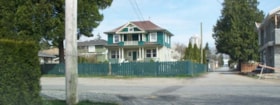
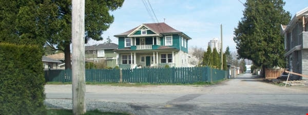
Naud House
https://search.heritageburnaby.ca/link/archivedescription58369
- Repository
- City of Burnaby Archives
- Date
- 2009
- Collection/Fonds
- Steve Jensen fonds
- Description Level
- Item
- Physical Description
- 1 photograph (jpeg) : col.
- Scope and Content
- Photograph of the O. G. Naud house at 4737 Victory Street as taken in 2009.
- Repository
- City of Burnaby Archives
- Date
- 2009
- Collection/Fonds
- Steve Jensen fonds
- Physical Description
- 1 photograph (jpeg) : col.
- Description Level
- Item
- Record No.
- 494-001
- Access Restriction
- No restrictions
- Reproduction Restriction
- No restrictions
- Accession Number
- 2009-03
- Scope and Content
- Photograph of the O. G. Naud house at 4737 Victory Street as taken in 2009.
- Subjects
- Buildings - Residential - Houses
- Media Type
- Photograph
- Photographer
- Jensen, Steve
- Notes
- Title based on contents of photograph
- Geographic Access
- Victory Street
- Street Address
- 4737 Victory Street
- Historic Neighbourhood
- Alta-Vista (Historic Neighbourhood)
- Planning Study Area
- Sussex-Nelson Area
Images
![Nelson Avenue School, [between 1911 and 1919] thumbnail](/media/hpo/_Data/_Archives_Images/_Unrestricted/316/325-041.jpg?width=280)
Nelson Avenue School
https://search.heritageburnaby.ca/link/archivedescription37169
- Repository
- City of Burnaby Archives
- Date
- [between 1911 and 1919]
- Collection/Fonds
- Burnaby Historical Society fonds
- Description Level
- Item
- Physical Description
- 1 photograph : b&w ; 8 x 12.5 cm print
- Scope and Content
- Photograph of Nelson Avenue School, which was established in 1912 to serve the Alta Vista district of Burnaby.
- Repository
- City of Burnaby Archives
- Date
- [between 1911 and 1919]
- Collection/Fonds
- Burnaby Historical Society fonds
- Subseries
- Disney family subseries
- Physical Description
- 1 photograph : b&w ; 8 x 12.5 cm print
- Description Level
- Item
- Record No.
- 325-041
- Access Restriction
- No restrictions
- Reproduction Restriction
- No known restrictions
- Accession Number
- BHS1996-04
- Scope and Content
- Photograph of Nelson Avenue School, which was established in 1912 to serve the Alta Vista district of Burnaby.
- Subjects
- Buildings - Schools
- Names
- Nelson Avenue School
- Media Type
- Photograph
- Photographer
- Disney, John Harold "Jack"
- Notes
- Title based on contents of photograph
- Geographic Access
- Irmin Street
- Street Address
- 4850 Irmin Street
- Historic Neighbourhood
- Alta-Vista (Historic Neighbourhood)
- Planning Study Area
- Sussex-Nelson Area
Images
![Nelson Avenue School, [between 1911 and 1919] thumbnail](/media/hpo/_Data/_Archives_Images/_Unrestricted/316/325-041.jpg)
![Riverway East School, [between 1911 and 1919] thumbnail](/media/hpo/_Data/_Archives_Images/_Unrestricted/316/325-023.jpg?width=280)
Riverway East School
https://search.heritageburnaby.ca/link/archivedescription37151
- Repository
- City of Burnaby Archives
- Date
- [between 1911 and 1919]
- Collection/Fonds
- Burnaby Historical Society fonds
- Description Level
- Item
- Physical Description
- 1 photograph : b&w ; 8 x 12.5 cm print
- Scope and Content
- Photograph of Riverway East (renamed Dundonald) School taken from River Road (now Marine Drive). A large pile of cordwood is visible alongside the school.
- Repository
- City of Burnaby Archives
- Date
- [between 1911 and 1919]
- Collection/Fonds
- Burnaby Historical Society fonds
- Subseries
- Disney family subseries
- Physical Description
- 1 photograph : b&w ; 8 x 12.5 cm print
- Description Level
- Item
- Record No.
- 325-023
- Access Restriction
- No restrictions
- Reproduction Restriction
- No known restrictions
- Accession Number
- BHS1996-04
- Scope and Content
- Photograph of Riverway East (renamed Dundonald) School taken from River Road (now Marine Drive). A large pile of cordwood is visible alongside the school.
- Subjects
- Buildings - Schools
- Names
- Riverway East School
- Media Type
- Photograph
- Photographer
- Disney, John Harold "Jack"
- Notes
- Title based on contents of photograph
- Geographic Access
- Gilley Avenue
- Marine Drive
- Street Address
- 5787 Marine Drive
- Historic Neighbourhood
- Alta-Vista (Historic Neighbourhood)
- Planning Study Area
- Clinton-Glenwood Area
Images
![Riverway East School, [between 1911 and 1919] thumbnail](/media/hpo/_Data/_Archives_Images/_Unrestricted/316/325-023.jpg)
![Riverway East School and Dundonald Church, [between 1911 and 1919] thumbnail](/media/hpo/_Data/_Archives_Images/_Unrestricted/316/325-024.jpg?width=280)
Riverway East School and Dundonald Church
https://search.heritageburnaby.ca/link/archivedescription37152
- Repository
- City of Burnaby Archives
- Date
- [between 1911 and 1919]
- Collection/Fonds
- Burnaby Historical Society fonds
- Description Level
- Item
- Physical Description
- 1 photograph : b&w ; 8 x 12.5 cm print
- Scope and Content
- Photograph of Riverway East (renamed Dundonald) School and Dundonald Untied Church taken from River Road (now Marine Drive). A large pile of cordwood is visible alongside the school.
- Repository
- City of Burnaby Archives
- Date
- [between 1911 and 1919]
- Collection/Fonds
- Burnaby Historical Society fonds
- Subseries
- Disney family subseries
- Physical Description
- 1 photograph : b&w ; 8 x 12.5 cm print
- Description Level
- Item
- Record No.
- 325-024
- Access Restriction
- No restrictions
- Reproduction Restriction
- No known restrictions
- Accession Number
- BHS1996-04
- Scope and Content
- Photograph of Riverway East (renamed Dundonald) School and Dundonald Untied Church taken from River Road (now Marine Drive). A large pile of cordwood is visible alongside the school.
- Media Type
- Photograph
- Photographer
- Disney, John Harold "Jack"
- Notes
- Title based on contents of photograph
- Geographic Access
- Gilley Avenue
- Marine Drive
- Street Address
- 5787 Marine Drive
- Historic Neighbourhood
- Alta-Vista (Historic Neighbourhood)
- Planning Study Area
- Clinton-Glenwood Area
Images
![Riverway East School and Dundonald Church, [between 1911 and 1919] thumbnail](/media/hpo/_Data/_Archives_Images/_Unrestricted/316/325-024.jpg)
![What A Ride We Had, [1944] thumbnail](/media/hpo/_Data/_Archives_Images/_Unrestricted/494/494-002.JPG?width=280)
What A Ride We Had
https://search.heritageburnaby.ca/link/archivedescription58374
- Repository
- City of Burnaby Archives
- Date
- [1944]
- Collection/Fonds
- Steve Jensen fonds
- Description Level
- Item
- Physical Description
- 1 photograph (jpeg) : b&w
- Scope and Content
- Photograph shows nine people posing on or near a car. The photograph was taken facing north off Beresford Street, half a block east of Royal Oak Avenue. Identified in the photograph are Molly Jensen (nee Carpenter) who is sitting in the back seat wearing glasses; Ernie Carpenter Jr. in the driver's…
- Repository
- City of Burnaby Archives
- Date
- [1944]
- Collection/Fonds
- Steve Jensen fonds
- Physical Description
- 1 photograph (jpeg) : b&w
- Description Level
- Item
- Record No.
- 494-002
- Access Restriction
- No restrictions
- Reproduction Restriction
- Reproduce for fair dealing purposes only
- Accession Number
- 2009-03
- Scope and Content
- Photograph shows nine people posing on or near a car. The photograph was taken facing north off Beresford Street, half a block east of Royal Oak Avenue. Identified in the photograph are Molly Jensen (nee Carpenter) who is sitting in the back seat wearing glasses; Ernie Carpenter Jr. in the driver's seat; and their mother Edith Carpenter sitting on the bonnet with her hand on the windshield. The rest are unidentified.
- Media Type
- Photograph
- Photographer
- Jensen, Steve
- Notes
- Title based on contents of photograph
- Geographic Access
- Royal Oak Avenue
- Beresford Street
- Historic Neighbourhood
- Alta-Vista (Historic Neighbourhood)
- Planning Study Area
- Clinton-Glenwood Area
Images
![What A Ride We Had, [1944] thumbnail](/media/hpo/_Data/_Archives_Images/_Unrestricted/494/494-002.JPG)