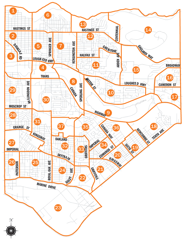
Search by Current Neighbourhood
To search for historic landmarks, photos, moving images, oral histories and some artifacts indexed by the Current Neighbourhood area, click on a neighbourhood on the map or select from the list below. Move your mouse over an area to display the neighbourhood name.

Current Neighbourhoods
- Burnaby Heights Area
- Willingdon Heights Area
- West Central Valley Area
- Dawson-Delta Area
- Brentwood Area
- Capitol Hill Area
- Parkcrest-Aubrey Area
- Ardingley-Sprott Area
- Burnaby Lake Area
- Government Road Area
- Sperling-Broadway Area
- Lochdale Area
- Westridge Area
- Burnaby Mountain Area
- Lake City Area
- Lyndhurst Area
- Cameron Area
- Cariboo-Armstrong Area
- Second Street Area
- Edmonds Area
- Stride Avenue Area
- Stride Hill Area
- Big Bend Area
- Clinton-Glenwood Area
- Sussex-Nelson Area
- Suncrest Area
- Maywood Area
- Garden Village Area
- Cascade-Schou Area
- Douglas-Gilpin Area
- Marlborough Area
- Windsor Area
- Kingsway-Beresford Area
- Richmond Park Area
- Morley-Buckingham Area
- Lakeview-Mayfield Area
- Oakalla Area